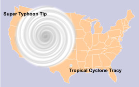
 Hurricanes can get much, much bigger and stronger than we have so far seen in the Atlantic. The most intense Pacific storm on record was Super Typhoon Tip in 1979, which reached maximum sustained winds of 190 mph near the center. On its wide rim, gale-force winds (39 mph) extended over a diameter of an astonishing 1,350 miles. It would have covered nearly half the continental United States.
“More than half the total hurricane damage in the U.S. (normalized for inflation and populations trends) was caused by just five events,” explained MIT hurricane expert Kerry Emanuel in an email. Storms that are Category 4 and 5 at landfall (or just before) are what destroy major cities like New Orleans and Galveston with devastating winds, rains, and storm surges.
In “part 2,” we’ll look a little more in detail at Katrina (and Gustav), and why they weren’t (and probably won’t be) as strong and hence as devastating at landfall as they could have been.
But let’s first ask, How did Katrina turn into a powerful Category 5 hurricane?
The National Climatic Data Center 2006 report on Katrina [PDF] begins its explanation by noting that the surface temperatures (SSTs) in the Gulf of Mexico during the last week in August 2005 “were one to two degrees Celsius above normal, and the warm temperatures extended to a considerable depth through the upper ocean layer.” The report continues, “Also, Katrina crossed the ‘loop current‘ (belt of even warmer water), during which time explosive intensification occurred. The temperature of the ocean surface is a critical element in the formation and strength of hurricanes.”
An important factor was that the ocean warming had penetrated to a considerable depth. One of the ways that hurricanes are weakened is the upwelling of colder, deeper water due to the hurricane’s own violent action. But if the deeper water is also warm, it doesn’t weaken the hurricane. In fact, it may continue to intensify. Global warming heats both the sea surface and the deep water, thus creating ideal conditions for a hurricane to survive and thrive in its long journey from tropical depression to Category 4 or 5 superstorm.
A 2005 study, “Penetration of Human-Induced Warming into the World’s Oceans,” led by Scripps Institution of Oceanography compared actual ocean temperature data from the surface down to hundreds of meters (in the Atlantic, Pacific, and Indian oceans) with climate models and concluded:
A warming signal has penetrated into the world’s oceans over the past 40 years. The signal is complex, with a vertical structure that varies widely by ocean; it cannot be explained by natural internal climate variability or solar and volcanic forcing, but is well simulated by two anthropogenically forced climate models. We conclude that it is of human origin, a conclusion robust to observational sampling and model differences.
This figure shows what they found:
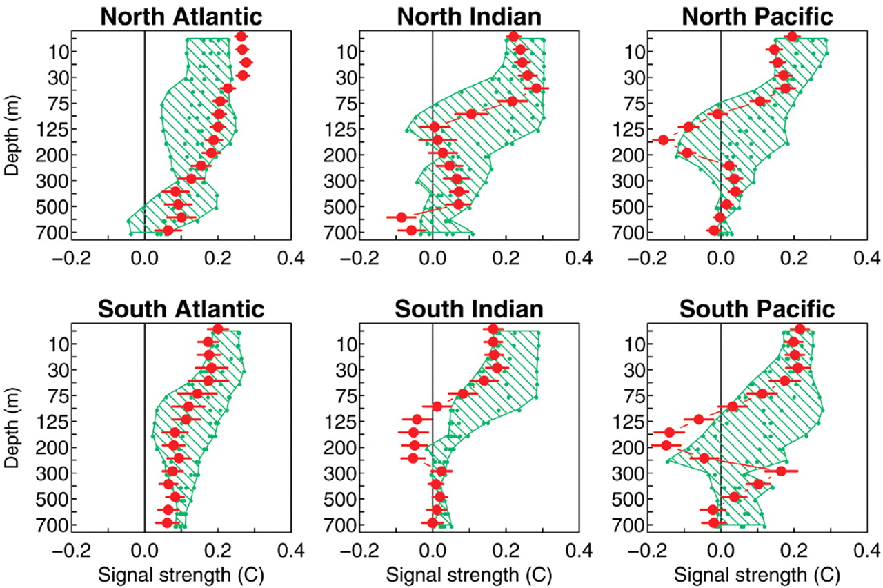
Figure: Anthropogenic forcing signal strength (green hatched region) compared to that obtained from the observations (red dots). There is excellent agreement at most depths in all oceans. The hatched region shows the range of the signal strength estimates from five different realizations of identically forced simulation with the Parallel Climate Model, whereas the smaller green dots within the region are the individual realizations. Click to enlarge.
(And yes, the latest analysis shows “that ocean heat content has indeed been increasing in recent decades, just like the models said it should.”)
Tropical cyclones are threshold events
Tropical cyclones are threshold events — if sea surface temperatures are below 80°F (26.5°C), they do not form. Some analysis [PDF] ($ub. req’d) even suggests there is a sea surface temperature “threshold [close to 83°F] necessary for the development of major hurricanes.” Global warming may actually cause some hurricanes and some major hurricanes to develop that otherwise would not have (by raising sea surface temperatures above the necessary threshold at the right place or time).
And the more warm, deep water that gets generated by global warming, the more super-intense hurricanes we will see. No wonder ABC News reported in 2006 that hurricane scientists are considering adding a Category 6, for hurricanes above 175 miles per hour. Ultimately, they may become common.
If we don’t reverse our emissions paths quickly, global temperatures will rise faster and faster through 2100 and beyond. This will translate into warmer oceans in all three dimensions: Warmth will spread over wider swaths of the ocean as well as deeper below the surface — we’ve already seen that in the first known tropical cyclone in the South Atlantic (2004) and the first known tropical cyclone to strike Spain (2005). That means we will probably see stronger hurricanes farther north along the East Coast in the coming decades.
More intense storms will be seen earlier and later in the season. The 2005 hurricane season was the most striking example of that trend, with Emily “the earliest-forming Category 5 hurricane on record in the Atlantic,” in July, and Zeta, the longest-lived tropical cyclone to form in December and cross over into the next year, where it became the longest-lived January tropical cyclone.
We have already seen a statistically significant increase in the length of the average hurricane season over the last several decades, according to a 2006 analysis [PDF]. The data from the past century indicates that a 1°F increase in sea surface temperatures leads to an extra five tropical storms a year in the Atlantic — an ominous statistic in a world taking no actions to stop a projected 2°F increase in average sea surface temperatures by mid-century, and more than double that by century’s end.
And this is not a worst-case prediction, where global temperatures could rise more than 9°F this century.
“Part 2” will look a little more in detail at Katrina and Gustav, and why future Gulf storms are all but certain to be more devastating at landfall.
This post was created for ClimateProgress.org, a project of the Center for American Progress Action Fund.

