
You probably would rather not think about the fact that Hurricane Sandy created a lot of sewage problems. Well, you’re lucky you don’t have to, because there are people whose job it is to do that. And they have satellites that allow them to get a sense of … well, there’s no way to say this nicely: how much raw sewage made it into our waterways as a result of the devastating storm.
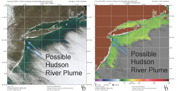
You can’t actually detect sewage from a satellite. Meaning it can’t take a picture of water that would allow them to look at an image and deduce, oh, that part of the water? That has human waste in it. However, “you can find river discharge that you suspect has raw sewage,” Matthew Oliver, assistant professor of oceanography in the College of Earth, Ocean, and Environment at University of Delaware, said in a press release. “The reason why is because river discharge usually has a very different temperature and color than the surrounding waters.”
From satellite data, environmental organizations in the mid-Atlantic states have been able to deduce this much about Sandy sewage: Hurricane Sandy damage caused several wastewater facilities to malfunction, and untreated sewage went into the Hudson River, Passaic River, Hackensack River, Newark Bay, Kill Van Kull and Arthur Kill, Raritan Bay, Raritan River, Sandy Hook Bay, and northern Barnegat Bay. Advisories are currently out about boating or fishing in all of these areas. Oh, shit.