This is the second in a four-part series about the L.A. River. Read part 1 here.

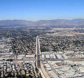
The L.A. River descends from the mountains into a sea of sprawl. (Photo by La Citta Vita.)
The Los Angeles River begins in the mountains that hem in the sprawl of the San Fernando Valley. Even up in these wild canyons, the city’s weird influences still resonate: One tributary creek carries runoff from the highly contaminated Santa Susana Field Lab, the site of the world’s first core meltdown in a commercial nuclear reactor, as well as extensive liquid rocket fuel spills. (Santa Susana might be what your dorm kitchen would look like if your roommates included hundreds of Space Age chemists with free access to plutonium and dioxins.) Not far north of there, another tributary runs through Spahn Ranch, the infamous hideout of the Manson Family.
Once these mountain creeks flow down into the valley’s landscape of strip malls and cul-de-sacs, they enter the familiar paved channels characteristic of waterways throughout the city. But there are still a few exceptions to that rule. The most notable is the Sepulveda Basin Recreation Area, where, for about 2.4 miles, the Los Angeles River flows more or less wild: meandering, unpaved, and free to flood periodically into the surrounding sports fields.
I visited there on a hot summer afternoon, by way of the city’s expanding Orange Line bus rapid transitway. From the Woodley Avenue station, I hiked past a golf course and through a complex of cricket fields, where a crowd of expats from the old British Empire — mostly Indian and Pakistani men — was gathering for an after-work match.
I left the irrigated sports fields behind and climbed an embankment to the Burbank Boulevard overpass, where I got my first sight of the unpaved Los Angeles River, surprisingly full and broad, with polished gravel sandbars weaving a braided path toward the embankments of the massive Sepulveda Dam. Aside from the droning engine whines coming from the city’s nearby model airplane landing field, it felt like a landscape straight out of the Old West, and it occurred to me that this place probably had been in a number of old westerns. (That scene from Drive that I’d mentioned in this series’ introduction is just upstream from this spot.)

A tributary creek in Hahamongna Canyon, on the edge of Pasadena (Photo by Christian MilNeil.)
River advocates and an increasing number of politicians would like to create wild river parks like this one throughout the L.A. metro area, where flood control, recreation, water conservation, and wildlife habitat can all coexist. A few miles east of Sepulveda Dam, on the Tujunga Wash, you can find the site of one of L.A. County’s first restoration efforts. There, in 2007, engineers built what is essentially a small, duplicate stream next to the larger paved channel. This greenway diverts some of the main channel’s water into a more natural gravel streambed surrounded by native vegetation and a cycling path. The project’s designers boast that the new stream helps absorb some of the Tujunga Wash’s riverwater into the aquifer, instead of flushing it out into the ocean.
It’s a pleasant enough place, and the new multi-use path was busy when I visited. Still, even post-“restoration,” the Tujunga Wash remains a very strange waterway. The new greenway, running parallel to the much larger concrete ditch, gives the unfortunate impression that this “restoration” is just window dressing — the real stream hasn’t changed.
Melanie Winter, a longtime watershed advocate and the director of The River Project, says the scope of the Tujunga Wash restoration project was too narrow (literally). Advocates like Winter envision a day when creeks like the Tujunga Wash might shed their concrete banks altogether — and look more like Sepulveda Basin.
In order to manage that goal without flooding neighborhoods where people live and work, however, L.A. would need to take a more holistic approach to watershed conservation — and make some serious transformations in its urban form. Acres of parking lots would need to be converted into green spaces that could absorb rainfall during storms, and more of the city’s growth would need to be concentrated into high-density, walkable neighborhoods, away from floodplains. Some streets might need to become narrower to further reduce runoff. Angelinos would use less pavement — and more public transit.
All this sounds pretty good to sustainability advocates — and to a growing number of political leaders. (More on that in the next installment in this series.) But until Los Angeles embraces those broader changes, says Winter, restoration efforts like the one at Tujunga Wash will end up spending more tax money (a scarce commodity in the Golden State) to achieve less.
“I couldn’t give a shit about a riverside greenway if that’s the main objective,” Winter says. “If you focus on the entire watershed — the land use, the tributaries, everything else — then you’ll get a greenway. You’ll also get a local, sustainable water supply, and better public transportation, better public health, and 50,000 other things.”
In other words: If you really want to restore the L.A. River, you’ll need to heal the whole city. In my next post, we’ll travel further downstream, toward downtown, and see how the city is working to make that happen in the very heart of Los Angeles.
Next: The challenge of reconnecting a city and its river.