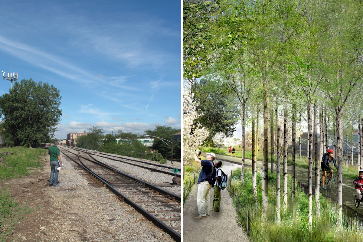
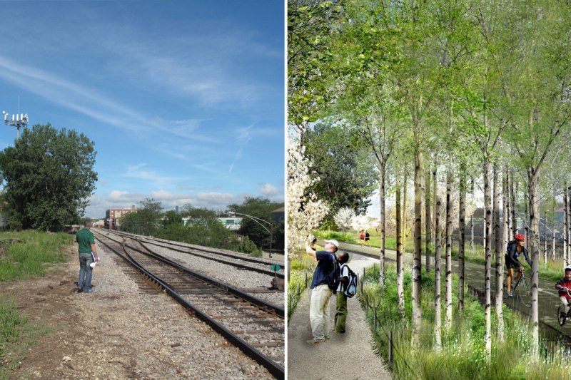
The Trust for Public Land / Michael Van Valkenburgh Associates, Inc.Proposed design for the Bloomingdale Trail. Click to embiggen.
Anyone who’s visited Chicago can see it was once a hub for rail industry: Abandoned tracks criss-cross The City of Big Shoulders like scars on a brawny boxer. Converting this brutal urban landscape into swaths of green might seem like a stretch, but Mayor Rahm Emanuel has pledged to create 800 new parks, recreation sites, and green spaces throughout the city over the next five years. The centerpiece of that effort includes two of the nation’s most ambitious urban parks: the Bloomingdale Trail and the Burnham Wildlife Corridor.
Come early summer, work begins on the Bloomingdale Trail, a 2.7-mile, elevated “sky park” that will replace an abandoned industrial rail line in northwest Chicago. Like a super-sized version of Paris’ Promenade-Plantee or New York’s High Line (which stretches a mere 1.4 miles), the $92 million Bloomingdale Trail will link to five ground-level parks, serve as a main transportation route for bicyclists and pedestrians, and function as an extended backyard for locals.
Then, in August, the Chicago Park District will put out a historic call for volunteers to help plant a staggering 125,000 trees and shrubs in one day for the new Burnham Wildlife Corridor, offering sanctuary for some of the 5 million birds that follow the lakeshore into the city during migration seasons — and often meet their ends when they collide with glass skyscrapers. The smudge of land, now choked with invasive species, is located on the city’s South Side, hemmed in by rail on one side and bustling Lake Shore Drive on the other.
One park is for the legged populace, another for the winged. But both reflect a recent awakening, in Chicago and elsewhere, of a desire to make more room for nature in cities. In some ways, planners say, greening these ghosts of industry past will make restitution for that rugged history.
As the benefits of urban parks and nature preserves — healthier people, less crime, and improved quality of life — increase in desirability, so goes design. Through programs like Rails to Trails, elevated parks are flourishing across the country: Repurposed rail projects include Atlanta’s BeltLine, New York’s QueensWay, and Philadelphia, Pa.’s Reading Viaduct project. New riverside parks in the works include St. Louis’ Confluence Greenway and the Midtown Greenway in Minneapolis.
The Bloomingdale Trail consists of 38 bridges along the former route for the Canadian Pacific Railway. At its highest point, the trail rises 18 feet off the ground. Ramps leading off the trail and into the adjacent neighborhoods will strengthen Chicago’s rep as a major biking hub, and could even spur economic development in the culturally diverse neighborhoods where they connect, says Beth White, director of the Chicago Region of The Trust for Public Land (which is managing the project).
Initiated by Friends of The Bloomingdale Trail, who once promoted the idea of the trail by posting Burma-Shave-style quizzes along Humboldt Boulevard (“What’s 18 feet off the ground and gives great views of the city?”), and 10 years in planning, the trail will offer public art, native plants, an outdoor observatory, and small theatre and concert venues. The park’s proximity to Lake Michigan and its fluctuating temperatures also make it an ideal ecology installation: From end to end it will be planted with indigenous trees that will alternately bloom and leaf out in sequence. Scientists who monitor these blooming and leafing periods over several years could gain precious clues into climate change’s effect on local botany. Paid for by state and federal funds and private donations, the trail is expected to be completed by the fall of 2014. If it receives a good public response, the trail will eventually be extended east to the Chicago River.
Meanwhile, the 2.2-mile-long, 40-acre Burnham Wildlife Corridor continues an ongoing plan by the park district to restore both prairie and woodland habitat along the lakeshore. Thousands of native oaks and fruit-bearing shrubs will offer food and respite to woodcocks, warblers, hawks, owls, and other bird life. While Chicago has dropped to the third-largest human population in the country, its location on the shore of Lake Michigan makes it a major hub for migrating birds, and the Burnham Wildlife Corridor will help keep it that way.
“On a good morning, the number of birds landing along the corridor could be in the thousands,” says Judy Pollock, director of bird conservation of Audubon Society’s Chicago Region. “When the birds come off the lake at dawn, they’re looking for a place to land. When they look down and see these wonderful green spaces in Chicago, I imagine they are saying to themselves, [in reference to the classic John Belushi Saturday Night Live skit about Chicago’s Billy Goat Tavern] ah, ‘cheeseburger, cheeseburger.’”
Stretching from 31st to 47th streets, the corridor borders neighborhoods that have endured years of economic hardship. As the trees and habitat flourish, a walking path will be added, helping to connect residents with nature, increase desirability, and possibly even revitalize the neighborhoods.
“Urban planning began right here in Chicago in the early 1900s,” says Doug Farr, an architect and author of Sustainable Urbanism: Urban Design With Nature who also chairs the Congress for New Urbanism. “It was a time of land grabs and making the big buck. And somehow, we forgot about the people and spaces and nature.
“But we’re rethinking it now,” Farr says, “retrofitting long-gone industry and unused space with things that flourish and grow.”