The broad high prairie of eastern Wyoming and southern Montana was once the bottom of a shallow sea, a rich subtropical swampland for millions of years. Layers of plants began forming peat beds 60 million years ago, later to be buried and compressed into bituminous coal strata.
The Missouri River became the dominant stream as the Northern Rockies formed, with tributaries like the Yellowstone, Powder, and Cheyenne rivers running north and east to meet it. Their erosion eventually left coal seams only a few feet beneath the land surface of what today is called the Powder River Basin.
No other coal seam on the planet is so big, so close to the surface, and so cheap to mine, said Thomas Michael Power, a professor emeritus at the University of Montana who studies energy economics.
A national debate
Today the massive deposits, enough to light the United States almost into the 23rd century, have become the center of a regional — and increasingly national — debate: Should this resource continue to be developed, how will it get to market and what is that market? The coal is so cheap that companies see profit in shipping it west via vast trains, a half-mile or more long, then clear across the Pacific Ocean to meet Asia’s seemingly insatiable demand.
There is also concern over the role coal plays in global warming and health impacts. Coal is the “dirtiest” fossil fuels, emitting mercury, nitrogen oxides, sulfur — and 2.5 tons of carbon dioxide for every ton of ore burned. Natural gas emits about half as much of the greenhouse gas. According to the Energy Information Agency, coal is source of 44 percent of global energy-related CO2 emissions.
There’s strong history here in the basin. And no shortage of conflict.
The region has been a western center of the American coal industry since the 19th century. Only after Clean Air Act amendments required lower sulfur levels in 1990 did the Basin’s low-sulfur bituminous and subbituminous coal become the dominant U.S. coal for generating electricity, power, and heat nationwide.
This rich grassland was home to herds of bison and native Cheyenne, Crow, and Lakota who were forcefully displaced by white pioneers and settlers, who then grazed thousands of head of cattle. Much of this 26,000-square-mile area is still grazed on a combination of private ranches, national grassland administered by the Department of Agriculture, and grazing allotments run by the Bureau of Land Management. BLM also controls the coal, oil, and other mineral rights; today, that’s where the money is.
The drive to develop coal has increasingly pitted ranchers against mining companies in a fight for water resources. Aquifers, pierced by mines, are draining away. What is sweet summer grassland to a rancher is overburden to be scraped away by a miner. Grazing allotments literally disappear as the U.S. Forest Service declares pasture unavailable due to mining activity.
“You just have to take a loss,” said rancher L.J. Turner from near Wright, Mont. “That 6,000 acres we lost supported our family.”
History also repeats here, though on a different scale.
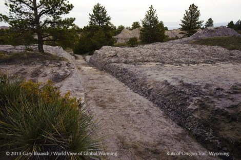
Just south of the Basin in Guernsey, Wyo., one can see pioneer wagon, oxen, and foot-worn ruts from the 1830s Oregon Trail, carved two to six feet deep into sandstone.
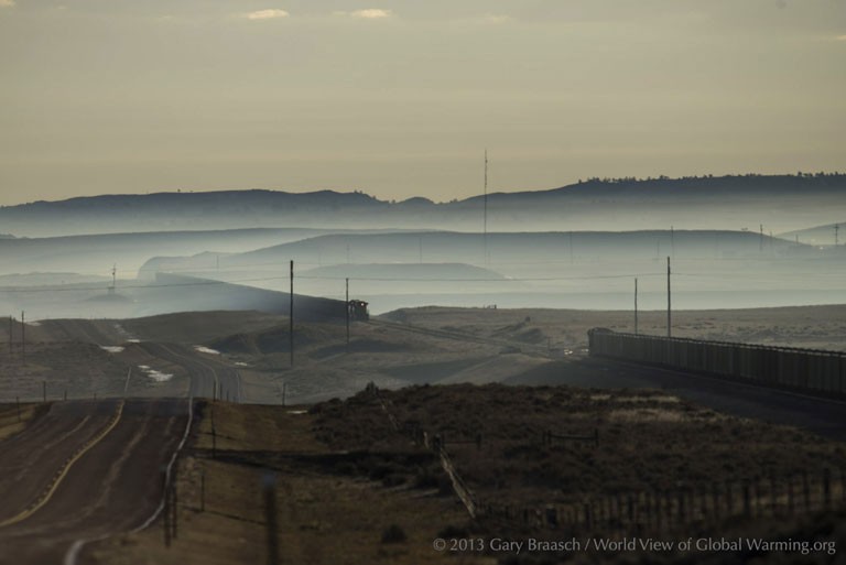
Now, for miles to the north into Montana the land is rutted, ripped and stripped by 16 huge open-pit coal mines, tracked by railroads carrying the black fuel to power U.S. electricity. And increasingly, it’s a landscape punctured by gas and oil wells.
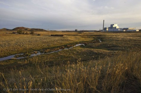
Gary BraaschA ranch on the Little Powder River north of Gillette, Wyo., now shares the land with the recently built Dry Fork Power Plant, generating 385 megawatts of electricity by burning coal from a nearby mine.
Quiet gravel roads
I spent a week this fall roaming the landscape, accompanied by environmental health scientist Joan Rothlein, to see where so much of America’s coal comes from and the source of proposed coal exports. Along the main two-lane highway where huge coal and oil industry semi trucks continuously loom in the rearview, and out on quiet gravel ranch roads where pronghorn antelope graze, we captured some of the people and work of today’s energy boom.
Only eight years ago coal power created more than half U.S. electricity; now it is down to about 37 percent due to the rise of natural gas and global warming concerns.
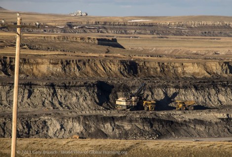
Gary BraaschPower shovel at work in the Caballo mine, owned by Peabody Energy Corporation, loading coal onto trucks from a coal seam more than 200 feet below the prairie surface.
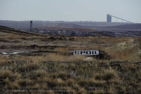
Under state and federal leases, mines are expanding through the grassland soils and surface rock, spitting it out as piled-up spoils and imperfectly restored land.
Emissions limits
Forty percent of American coal comes from this part of Wyoming and southern Montana, and almost all of it is burned to generate electricity. Coal burning power plants, according to BLM figures, create 13 percent of U.S. carbon dioxide emissions — more than any other single activity. The coal and power industries now face new Environmental Protection Agency emissions limits.
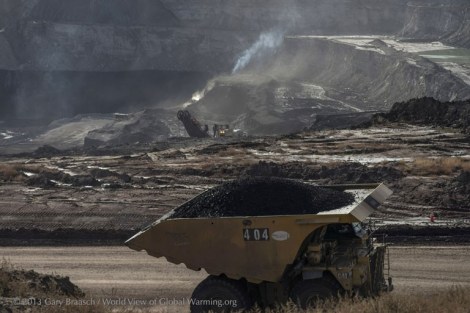
Gary BraaschA truck loaded with coal powers out of the Eagle Butte Mine, which produces about 20 million tons of coal per year for the Alpha Natural Resources company.
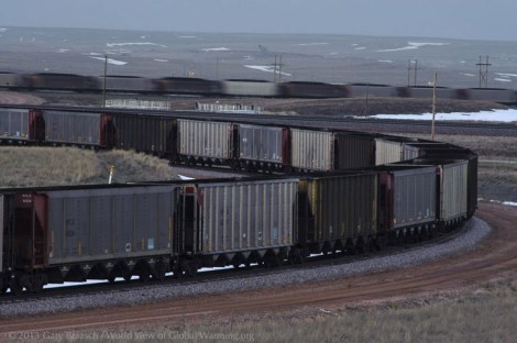
Big trucks, long trains
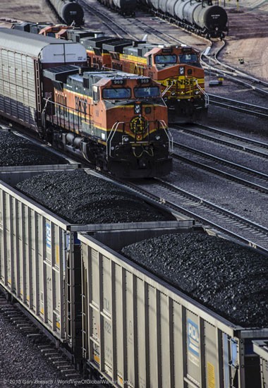
Not much here is small: The trucks are 40 feet long, 20 feet high at the cab and roll on six 11 foot diameter tires. They carry 200 tons of coal, dumping it onto a conveyor that transfers the coal to trains of up to 150 hopper cars.
Grass grows in a reclaimed mining area north of Wright, Wyo. Coal companies tout the success of reclamation. BLM regulations require performance bonds and say mined areas must be restored to “approximate original contours” with water and habitat in “healthy condition.”
But the Western Organization of Resource Councils, a nonprofit fighting coal development, analyzed BLM reports and found otherwise: “Coal mining has disturbed more than 162,000 acres of land in Wyoming,” the group wrote, “but only 4 percent of this land has gained final reclamation status” with full restoration and legal release from the bond.
Coal trains roll near the North Antelope Rochelle Mine, owned by Peabody Energy Corporation. This is the most active coal mine in the United States, producing 107.7 million tons of coal in 2012 – more than 10 percent of all U.S. production.
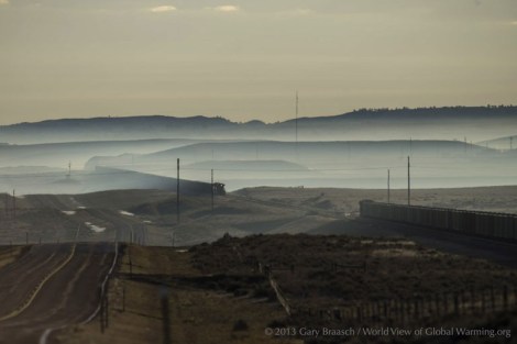
Gary BraaschDust from blasting, mine work and heavy truck traffic on gravel roads casts a pall over the landscape. EPA monitoring station data shows worsening air pollution since 1980 as more coal has been mined.
“Dust pneumonia”
Very few people live directly adjacent to the coal mines now, but mines are expanding near the Gillette and Wright areas. On the range near roads and mines, ranchers report young cattle and horses can suffer from “dust pneumonia.”
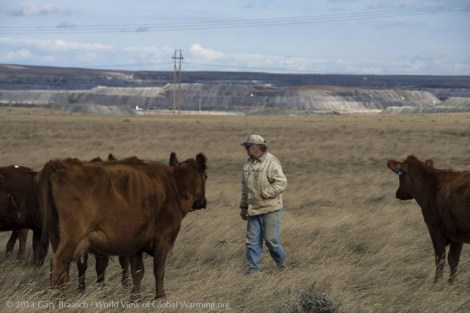
Gary BraaschRancher L.J. Turner looks after some of his red angus cattle on a pasture he leases from the federal Thunder Basin National Grassland.
The success of Turner’s herd depends on this rich prairie. But underneath lies a thick seam of coal — and the giant North Antelope Rochelle Mine in the background is gobbling up the prairie to get to it.
Mining has priority
Mining has priority among the values of this federal land, so the mine has been permitted to truck off as “overburden” about 6,000 of the 7,500 acres in Turner’s original grazing allotment.
That rich summer grass supported Turner’s family. Now there may be harder times ahead.
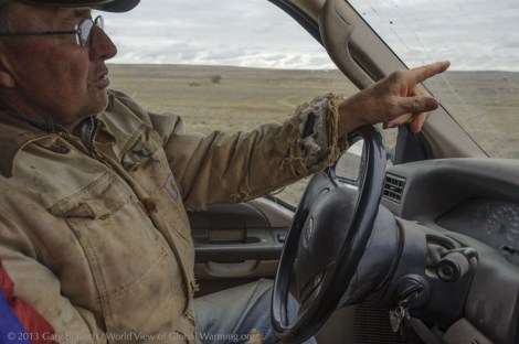
Gary BraaschTurner, born and raised on this land his family has owned since 1918, points across the 10,000 acre ranch to some of the streams that have dried up in recent years. He blames coal mining.
Creeks like Antelope Creek dry up in summer now, except for spring holes. Fish, beaver, mink, and muskrats are mostly gone.
“From Antelope Creek north to Gillette all the aquifers are being cut by mines,” he said. “Water upstream is draining away.”
“Just gone”
Turner says the aquifer lies at about 90-100 feet deep, so when it is sliced open by blasting and power shovels, water collects in bottom of the mines. Some of the water is pumped out, some used for wetting the mine roads or other mine uses.
But for a rancher, “it’s just gone.”
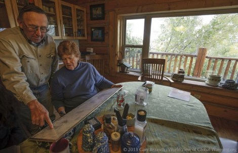
“My biggest concern is water. There’s not enough of it now, and it’s dirty,” said Karen Turner, looking over a map of their ranch and government grassland leases with her husband, L.J. “We drink bottled water because our water smells like hydrogen sulfide, and it didn’t used to.”
Along with the encroaching coal mines, many wells for oil and natural gas have been drilled recently and more are being negotiated on and near the ranch. The Turner’s gain some income from wells on their land, but they do not own the mineral rights beneath.
The quiet and traditional ranching life “is gone and not coming back,” L.J. Turner said. Ranch hands are hard to find because of the higher-paying oil and coal jobs.
Their young adult children love the ranch, but “are not enthusiastic about coming back to do battle,” including court fights with state authorities over protection of springs and smaller water sources.
For Karen, the drilling and mining “makes you angry — sick with anger.”
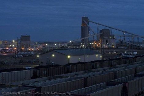
The loading area is a hive of activity at Arch Coal Company’s Black Thunder Mine, the second greatest producer but the largest mine in the Powder River Basin. Aerial photos by Skytruth in 2012 showed this mine has dug up and scarred more than 40 square miles — almost the area of San Francisco.
Black Thunder Mine produced 93 million tons of coal in 2012 and employed 1,635 people.
Gary BraaschCoal cars stage for loading at the Black Thunder Mine near Wright, Wyo.
Up to 100 coal trains are loaded daily in the Powder River Basin and leave day and night on railroad tracks bound for more than 200 power plants to the east, south, and increasingly, west.
In the Basin, coal companies have been paying only a dollar a ton to the BLM for coal from federal land leases. Last summer, one bid of 21 cents a ton was rejected by the BLM and another lease offer got no bids.
Analysts peg the slump to two factors: cheap natural gas and climate change regulations.
Exports vs. domestic need
Publicly owned coal is supposed to be sold to the companies at a “fair market price” to meet national energy needs. An Interior Department Inspector General report on Powder River Basin coal in 2013 said that, to the contrary, sale prices have been too low, mine data supplied by the companies has not been independently verified and high export prices for coal not counted in “fair market” calculations.
Exported coal fetches up to 10 times the approximately $10 per ton price paid by domestic end users.
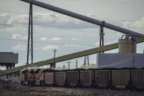
Gary BraaschA westbound 115-car train packed with Powder River Basin coal passing through the Wyodac Power Plant outside of Gillette.
Coal companies have been courting both export markets in Asia and port officials in Oregon and Washington, hoping to greatly increase coal exports. Peabody Energy’s CEO called it “a new era of U.S. exports … to the world’s best market for coal.”
Three large Northwest export terminal applications are in the study and permitting process. Expansion could mean 40 trains a day, rather than the two or three now, rumbling the 1,400 miles to the West Coast through the environmentally sensitive Columbia River Gorge and blocking traffic in scores of towns along the way.
According to BNSF studies, from 10,000 to 64,000 pounds of coal dust and chunks are blown and rattled off each mile-long train per 400 mile trip.
Strong opposition
Expansion plans have created strong opposition from some Western leaders and citizens. Lawsuits have been filed against the EPA charging violations of the Clean Water Act from coal along the tracks. Twenty-one environmental groups asked in April for “an immediate moratorium on new coal leasing in the Powder River Basin” on payment, health, and climate change grounds.
In response, the Department of Interior said it already reports greenhouse gas effects from the burning of coal when considering new mines. It also noted ongoing reviews of leasing and pricing programs.
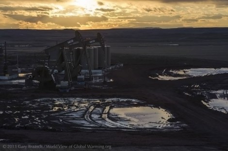
Gary BraaschA new double pump-jack pulls oil from a well outside of Wright.
In addition to coal, the ground under the Powder River Basin also holds reservoirs of petroleum and methane, lately exploited in a rush of wells and pipelines.
The Basin now leads the state in oil production. The shale gas and oil is usually extracted by hydraulic fracturing — the injection of water, chemicals and fine sand into wells in the process called fracking — while coal bed methane is released by pumping water out of deep coal strata. Brackish wastewater from wells — called “produced water” – is pumped out on land, reinjected into wells, or pumped into filtering ponds.
New regulations
Wyoming has new regulations starting in March 2014 for energy operators to test fresh water wells and springs within a half mile of drilling sites to monitor any pollution.
The EPA estimates that each fracked oil well requires 2 to 4 million gallons of water. The water comes from aquifers used for drinking water and ranching. Water, already a contentious issue in the West, has become even more so as the gas drilling and coal mining intensifies.
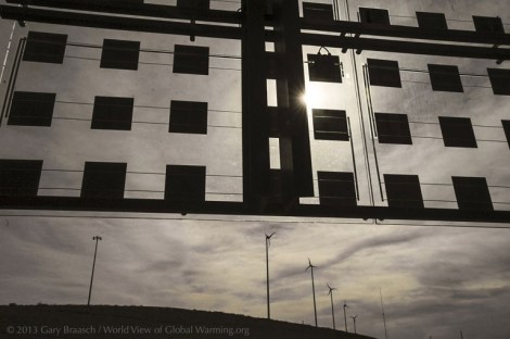
Gary BraaschCould this be the future? An integrated solar photo-voltaic and glass panel on the SW Wyoming Visitor Center near Cheyenne frames a set of mid-sized wind turbines on a hill outside the center.
The center is an advertisement for Wyoming’s potential as a renewable energy leader. But Wyoming lags behind 14 other states in wind power, even though it has the eighth highest potential, according to U.S. Department of Energy figures.
Wind power promise
To the west of the Powder River Basin, several large new wind farms are being planned, but in November Duke Energy accepted a federal criminal plea agreement to pay $1 million for bird kills at two established turbine arrays.
The coal and petroleum-rich Powder River Basin also holds wind power promise. The Turners have had three test anemometers on their ranch for more than six years. “It’s fantastic,” Karen Turner said, looking at the wind speed and consistency record. “The capacity factor is 50 percent. Most wind farms are viable at 20 percent.”
But lack of tax credit for renewable energy and other economic factors keep wind from being installed in their area, Turner said.