Two weeks ago I blogged that NASA reports hottest June to September on record; NOAA says “weak” El Niño “expected to strengthen and last through” winter.
NOAA’s National Weather Service Climate Prediction Center (and most other models) have been predicting for a couple of months that the weak El Niño would strengthen, but it hasn’t. Until now, that is.
This sea surface temperature (SST) data is from the NOAA’s October 26 weekly update on the El Niño/Southern oscillation, “ENSO Cycle: Recent Evolution, Current Status and Predictions“:
It is the warming in the Nino 3.4 region of the Pacific that is typically used to define an El Niño. The region can be seen in this figure:

How are El Niño and La Niña defined?
El Niño and La Niña are officially defined as sustained sea surface temperature anomalies of magnitude greater than 0.5°C across the central tropical Pacific Ocean. When the condition is met for a period of less than five months, it is classified as El Niño or La Niña conditions; if the anomaly persists for five months or longer.
You can read the basics about ENSO here. The following historical data are from NOAA’s weekly ENSO update:
As the planet warms decade by decade thanks to human emissions of greenhouse gases, making this the hottest decade in recorded history by far, global temperature records tend to be set in El Niño years, like 2005, 1998, and 2007, whereas sustained La Niñas tend to cause relatively cooler years.
Most models are not predicting an uber-El Niño as we saw in 1998, but NOAA’s own CFS (Climate Forecast System) issued last week projects a moderate El Niño lasting through next summer:
What would that mean?
Back in January, NASA had predicted: “Given our expectation of the next El Niño beginning in 2009 or 2010, it still seems likely that a new global temperature record will be set within the next 1-2 years, despite the moderate negative effect of the reduced solar irradiance.“
The recent outstanding AP story, “Statisticians reject global cooling,” ends:
Oceans, which take longer to heat up and longer to cool, greatly influence short-term weather, causing temperatures to rise and fall temporarily on top of the overall steady warming trend, scientists say. The biggest example of that is El Nino.
El Nino, a temporary warming of part of the Pacific Ocean, usually spikes global temperatures, scientists say. The two recent warm years, both 1998 and 2005, were El Nino years. The flip side of El Nino is La Nina, which lowers temperatures. A La Nina bloomed last year and temperatures slipped a bit, but 2008 was still the ninth hottest in 130 years of NOAA records.
Of the 10 hottest years recorded by NOAA, eight have occurred since 2000, and after this year it will be nine because this year is on track to be the sixth-warmest on record.
The current El Nino is forecast to get stronger, probably pushing global temperatures even higher next year, scientists say. NASA climate scientist Gavin Schmidt predicts 2010 may break a record, so a cooling trend “will be never talked about again.”
UPDATE: Gavin emailed me that “I actually meant that a cooling trend from 1998 wouldn’t be talked about again. Obviously, if 2010 is a record year then the talk will turn to a cooling trend from 2010 as early as summer 2011. These people, unlike the climate on a year to year basis, are extremely predictable.”
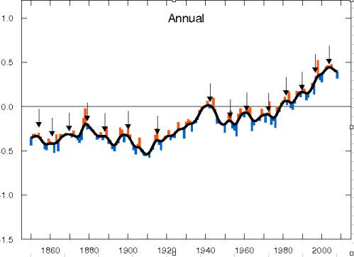
Yes, if the ensemble mean CFS prediction above comes true, then 2010 will probably break the temperature record and the “no warming in 10 years” meme will die — at least until the next La Niña or major volcano and/or general lapse in coverage by the status quo media, as the “best climate blog you aren’t reading” depicted with this figure:
It’s always cooling, except, of course, when it’s not.
- Skeptical Science explains how we know global warming is happening: It’s the oceans, stupid!
- Sorry deniers, hockey stick gets longer, stronger: Earth hotter now than in past 2,000 years
- The data show the planet STILL keeps warming
- Yes, the planet has kept warming since 1998
- Yes, the globe is warming. But how fast?
- “Hadley Center to deniers: We are STILL warming”
- NASA: 2007 Second Warmest Year Ever, with Record Warmth Likely by 2010


