ENSO Alert System Status: El Niño Watch
Synopsis: Conditions are favorable for a transition from ENSO-neutral to El Niño conditions during June − August 2009.
So begins the monthly El Niño/Southern oscillation (ENSO) Diagnostic Discussion issued by the Climate Prediction Center of NOAA’s National Weather Service. This is a significant change from their recent predictions of ENSO-neutral conditions for the rest of the year (see “La Niña conditions end“). You can read the basics about ENSO here.
Figure 3: Area-averaged upper-ocean heat content anomalies (°C) in the equatorial Pacific (5°N-5°S,
180º-100ºW).
I’ll go through the report in some detail since this is potentially a very big deal for the climate debate. After all, the La Niña conditions over the past 18 months helped temporarily mute the strong human-caused warming signal, allowing the global warming deniers to push their nonsensical global cooling meme with the help of the status quo media (see “Media enable denier spin 1: A (sort of) cold January doesn’t mean climate stopped warming“).
Remember that back in January, NASA had predicted:
Given our expectation of the next El Niño beginning in 2009 or 2010, it still seems likely that a new global temperature record will be set within the next 1-2 years, despite the moderate negative effect of the reduced solar irradiance.
ENSO doesn’t change the overall warming trend, but it is a short-term modulation, what NASA labels the largest contributor to the “natural dynamical variability” of the climate system. How are El Niño and La Niña defined?
El Niño and La Niña are officially defined as sustained sea surface temperature anomalies of magnitude greater than 0.5°C across the central tropical Pacific Ocean. When the condition is met for a period of less than five months, it is classified as El Niño or La Niña conditions; if the anomaly persists for five months or longer.
The following historical data are from NOAA’s weekly ENSO update:
As the planet warms decade by decade thanks to human emissions of greenhouse gases, global temperature records tend to be set in El Niño years, like 1998, 2005, and 2007, whereas sustained La Niñas tend to cause relatively cooler years.
As a side note: Roger Pielke, Sr.’s “analysis” of how there supposedly hasn’t been measurable ocean warming from 2004 to 2008 is uber-lame. In the middle of a strong 50-year warming trend, any clever (but cynical) analyst can connect an El Niño-driven warm year to a La Niña-driven cool year a few years later to make it look like warming has stopped. In fact, the latest analysis shows “that ocean heat content has indeed been increasing in recent decades, just like the models said it should.”
Human-caused global warming is so strong, however, that as NASA explained, it took a serious La Niña, plus unusually sustained low levels of solar irradiance, to make 2008 as cool as it was. Yet, notwithstanding the global warming deniers and the status quo media, 2008 wasn’t actually cool. Indeed, 2008 was almost 0.1°C warmer than the decade of the 1990s averaged as a whole.
So if we have an El Niño, then, as NASA says, record global temperatures are all but inevitable. And this brings us back to NOAA’s prediction today:
… sea surface temperatures (SST) increased for the fifth consecutive month, with above-average temperatures extending across the equatorial Pacific Ocean by the end of May (Fig. 1). Accordingly, the latest weekly SST indices ranged between +0.4° to +0.5°C in all four Niño regions (Fig. 2). Subsurface oceanic heat content anomalies (average temperatures in the upper 300m of the ocean, Fig. 3) also continued to increase in response to a large area of above-average temperatures (+2° to +4°C) near thermocline depth (Fig. 4). These surface and subsurface oceanic anomalies typically precede the development of El Niño…
There continues to be considerable spread in the model forecasts for the Niño-3.4 region (Fig. 5).
Figure 5: Forecasts of sea surface temperature (SST) anomalies for the Niño 3.4 region (5°N-5°S, 120°W-
170°W).
All statistical models predict ENSO-neutral conditions will continue for the remainder of 2009. However, most dynamical models, including the NCEP Climate Forecast System, predict the onset of El Niño during June − August 2009. Current observations, recent trends, and the dynamical model forecasts indicate that conditions are favorable for a transition from ENSO-neutral to El Niño conditions during June − August 2009.
A hot summer — how timely that would be for debating a climate bill!
Will we set a record this year for global temperature? Too soon to say, especially since the strong La Niña this winter will no doubt partly offset whatever impact the El Niño has.
And not that there was any realistic chance global temperatures would collapse this year, but it is even safer to say that “this will be the hottest decade in recorded history by far.“ The 2000s are on track to be nearly 0.2°C warmer than the 1990s. And that temperature jump is especially worrisome since the 1990s were only 0.14°C warmer than the 1980s.
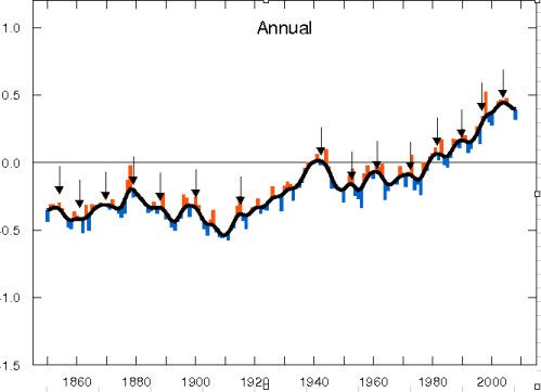
Once we set the global temperature record, then the “no warming in 10 years” meme will die — at least until the next La Niña or major volcano and/or general lapse in coverage by the status quo media, as the “best climate blog you aren’t reading” depicted with this figure:
It’s always cooling, except, of course, when it’s not.
Related Posts:
- Sorry deniers, hockey stick gets longer, stronger: Earth hotter now than in past 2,000 years
- The data show the planet STILL keeps warming
- Yes, the planet has kept warming since 1998
- Yes, the globe is warming. But how fast?
- “Hadley Center to deniers: We are STILL warming”
- NASA: 2007 Second Warmest Year Ever, with Record Warmth Likely by 2010


