A super-hurricane is brewing in the Atlantic Ocean in the opening pages of The Displacements, a novel by Bruce Holsinger published in 2022. “This is the one the climatologists have been warning us about for 20 years,” one character declares. Forty pages in, so-called Hurricane Luna makes a surprise turn for Miami and ends up demolishing Southern Florida with a wall of water, buckling skyscrapers, leveling wastewater plants, and filling the Everglades with contaminated silt. With 215-mile-per-hour winds, faster than a severe tornado, the fictional Luna is the world’s first Category 6 hurricane.
In the real world, Category 5 is synonymous with the biggest and baddest storms. But some U.S. scientists are making the case that it no longer captures the intensity of recent hurricanes. A paper published Monday in the Proceedings of the National Academy of Sciences lays out a framework for extending the current hurricane rating system, the Saffir-Simpson scale, with a new category for storms that have winds topping 192 miles per hour. According to the study, the world has already seen storms that would qualify as Category 6s.
“We expected that climate change was going to make the winds of the most intense storms stronger,” said Michael Wehner, a coauthor of the paper and an extreme weather researcher at Lawrence Berkeley National Laboratory. “What we’ve demonstrated here is that, yeah, it’s already happening. We tried to put numbers on how much worse it’ll get.”
There’s a reason that books like The Displacements invoke Category 6: It grabs your attention, warning of a threat that’s like nothing you’ve never encountered. The concept could help the public grapple with the dangers that climate change is bringing, like more intense storms. But some experts aren’t convinced it would be helpful to work “Category 6” into our hurricane vocabularies.
What storms would count as a Category 6?
The idea of adding a Category 6 has surfaced several times in the last few decades, as storms like Hurricane Dorian in 2019 delivered some of the highest wind speeds on record (185 miles per hour) and flattened whole towns in the Bahamas. The current Category 5 designation refers to any tropical cyclone with wind speeds higher than 157 miles per hour.
The new threshold of 192 miles per hour for a Category 6 would have captured some of the strongest storms ever observed. Wehner and his coauthor James Kossin, a scientist at the climate nonprofit First Street Foundation, found that at least five storms have already reached this tier, and that all of them occurred in the last decade, a signal that a warming world is creating more monster storms. The most powerful of these gales, Hurricane Patricia, slammed into Mexico’s Pacific Coast in 2015 with winds that peaked at 215 miles per hour. By a stroke of good fortune, the storm hit a relatively unpopulated region, causing only six deaths. When another one of the most powerful storms, Typhoon Haiyan, struck the Philippines in 2013 with winds of 195 miles per hour, it killed more than 6,000 people, making it one of the deadliest disasters in modern history.
The Gulf of Mexico hasn’t seen a storm with such high winds in the modern era, but the authors found that conditions in the region are already ripe for a Category 6. That’s because climate change is making the ocean and atmosphere warmer, providing fuel for more intense hurricanes. By undertaking an analysis of atmospheric conditions in the Atlantic, Wehner and Kossin found that there have been several occasions when the Gulf has been hot enough to support a storm with winds of more than 190 miles per hour — it’s just dumb luck that one hasn’t happened yet. As the world gets hotter, the odds that we’ll see such a storm get higher: The authors find that 2 degrees Celsius of warming would triple the risk of a Category 6 storm forming in the Atlantic in any given year.
The pitfalls of adding a new category
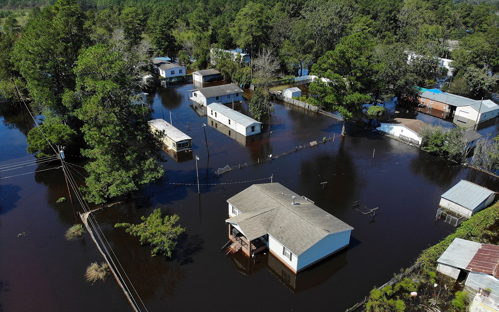
It’s becoming clear that flooding is the deadliest aspect of a hurricane. Storm surges account for roughly half of deaths from hurricanes in the United States, and flooding from heavy rain is responsible for more than a quarter, according to the study. By contrast, high winds are behind just 8 percent of deaths. Since the Saffir-Simpson scale is based solely on the speed of their winds, it doesn’t communicate the risks that people should be most concerned about, yet it’s the main thing people usually know about an oncoming storm.
“The point is, adding a Category 6 just amplifies the miscommunication of the greatest hurricane risks,” said Marshall Shepherd, a professor of atmospheric sciences at the University of Georgia.
The public is already confused by the jargon in hurricane forecasts, like the “cone of uncertainty” that shows a storm’s projected path, or the difference between a “watch” and a “warning.” Shepherd thinks adding a new category could make that worse.
“You know, people are creatures of habit,” he said. “They have been conditioned to believe that Cat 5 is the strongest hurricane. ‘OK, now, well, what are the categories?’ To me, it creates a lot more communication inconsistencies and confusion for the public.”
People often base their evacuation decisions on a storm’s Saffir-Simpson category, according to Jennifer Collins, a professor of geoscience at the University of South Florida. When Hurricane Florence was downgraded from a Category 4 to Category 1 before its landfall in the Carolinas in 2018, people who had evacuated actually turned around and came back, encountering severe flooding as a result, Collins said.
“When they hear Category 5, I think people will react to it,” Collins said. “It’s really when we use those lower categories that people are not reacting when they should.” National Hurricane Center experts have said in the past that adding a new category wouldn’t do much good, since a Category 5 is already considered catastrophic. Since the National Hurricane Center is in charge of the Saffir-Simpson scale, Category 6 won’t happen unless those experts are convinced it’s needed.
The authors of the new paper don’t think that extending the category system would fix these hurricane-communication problems. “We’re not trying to address these other inadequacies,” Wehner said. “We’re trying to raise awareness that climate change is increasing the risk of intense storms, and not just Category 6, but also category 4 and 5.”
While it’s difficult to predict exactly how people would respond to a Category 6 storm, Jennifer Marlon, a research scientist at the Yale Program on Climate Change Communication, thinks the designation would be helpful. “It would send a clear signal to coastal residents that your past experience with storms is not a good measure of future impacts,” Marlon said in an email. “Storms are no longer ‘all natural,’ and they’re getting stronger.”
A better way to communicate hurricane risks?
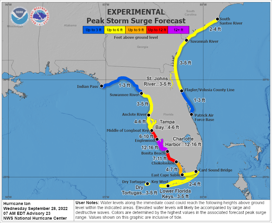
These days, when a hurricane is headed toward the coast, Shepherd doesn’t talk much about its category at all. Instead, he focuses on explaining threats from storm surge and flooding, sharing visuals that show the risks.
Over the last decade, the National Hurricane Center has been experimenting with new storm surge maps that highlight the risk of inland flooding rather than the wind speed of a storm. In the lead-up to hurricanes like Ian in 2022, for instance, the agency published new maps every few hours that showed how many feet of flooding will hit each segment of the coast. These maps are simple and easy to understand, and they’ve become a more central part of the NHC’s attempts to communicate storm risk in recent years.
“We likely have entered a new generation of hurricanes, in terms of intensity and rapid intensification,” Shepherd said. “I don’t want to downplay or underplay that, because that’s critical. So instead of worrying about characterizing a new category, my broader message is, ‘OK, what are we going to do, from an adaptation and a resiliency standpoint, to this new generation of hurricanes?’”