 Photo: Chuck WolfeCross-posted from the Natural Resources Defense Council.
One of the tenets of Buddhism is mindfulness: being fully present and aware. Although I am far from a religious person, I get that, at least in theory. If one is fully committed to something, even a task as simple and familiar as eating a meal, one is more complete, more alive, or so it seems to me.
(Bear with me. The philosophical part of the post doesn’t last too long.)
When we are less than fully mindful, however, as we tend to be all the time in today’s hyper-multitasked world, we miss a lot. By attempting to experience everything, we experience nothing in depth. And so it is with the places around us — where we live, work, and visit. We know them well in some ways, I guess, but not as well as we could.
So sometimes we need a little help focusing. This can come in the form of a new way to experience, to think about, our cities and neighborhoods. A fresh perspective, if you will. Fortunately, several of my urbanist friends and the people I follow in the media are showing us the way.
Here are five ways to see familiar places differently, and thus to learn about them:
1. Document them
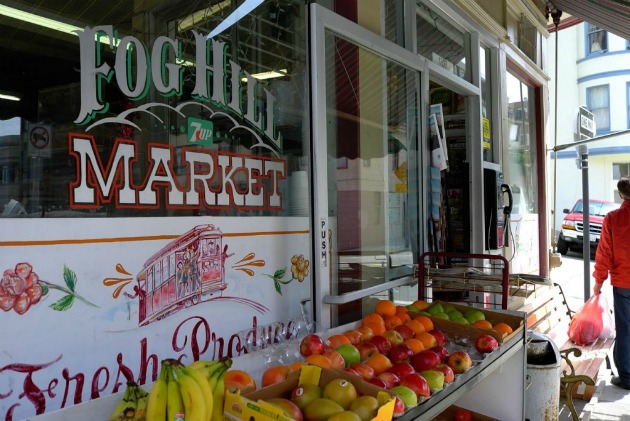
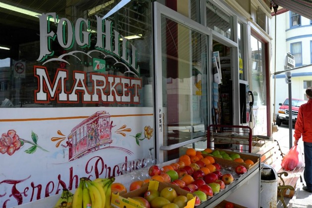
 Photo: Chuck WolfeChuck Wolfe, on his always-provocative blog myurbanist, urges us to “create an urban diary.” For Chuck himself, a superb photographer, more often than not this means photographing, as with his image of San Francisco’s Fog Hill Market shown at the top of the post. But writing and drawing work, too. The key is purposeful involvement with a place:
The premise is simple: cities are hubs of human interaction, and the urban experience can be enhanced by authentic participation in the dynamics of a place and transitions to nearby venues, including other neighborhoods, or, in certain instances, nearby towns.
With the advent of the internet, this story is told with more than just words. Websites celebrate the possibilities for narrow streets in Los Angeles, alleys in Seattle, walkability in Dallas, and the legacy of Jane Jacobs’s urban spaces. in particular, small-scale. multimedia producers such as Streetfilms document and celebrate notable examples — usually cities of inspiration from around the world.
Simultaneously, the growing art of urban exploration-infiltrating and documenting cities in new, often controversial ways-offers more “experiential understanding.” However, as recently voiced with some skepticism by Bradley Garrett in Domus, citizen fascination and compilation of urban decay or hidden infrastructure should not be confused with more studied academic documentary efforts.
Rather than simply receive and review such messages (or debate their validity), why not document your own choice of how to live? Why not create your own urban diary? …
Personal documentation of the journey from place to space — crossing and intersecting the public and private realms — may be the best way to understand where we live, the choices we make and those that are made for us.
As a writer and photographer myself, I know I experience places and events differently when I am documenting, or using them to create, than I do otherwise. It creates perspective and purpose. I notice different things. (That’s not always good, by the way; sometimes putting the camera or note pad down in order to have a more direct and personal immersion is the better thing to do. But generally the experience of documenting does add concentration and mindfulness.) Read all of Chuck’s article here.
2. Name them
My friend Steve Mouzon, who articulates simple but deep truths about places in as compelling a way as I have encountered, recently wrote in his Original Green Blog about the power of names — and, in particular, of naming a place that previously has been nameless. Steve articulates his thoughts in the context of helping recovering neighborhoods in New Orleans:
Southerners, especially those from the Crescent City, are often master story-tellers. Many of them will tell you that they can weave a more compelling tale when places and buildings in that tale have nifty names … ‘Dead Man’s Curve’ rather than ‘highway 431, a couple miles out of town. ‘High Rustler’ instead of ‘the efficiency unit in Robert Orr’s house.’ ‘Printer’s Alley’ rather than ‘the alley between 3rd and 4th Avenues.’ Tara was by no means the first southern house to be named, nor the last …
Our study area contained place after nameless place with the beginnings of coolness. Sometimes, it was because of the people moving there, like the rag-tag band of artists opening a few galleries on a certain stretch of St. Claude. Other times, it was because of the physical configuration of the place, like the funky little double triangle where you can find Flora’s, Mimi’s, and Schiro’s.
So why not name each of these places? The galleries on St. Claude could be Gallery Row. What aspiring new artists wouldn’t want to be located on Gallery Row? Every town has its Five Points, but the funky little double triangle actually has seven streets coming out of it, so it should be Seven Points.
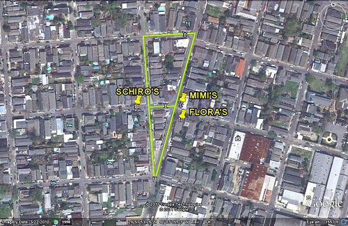 See the image to the right for what I believe to be Steve’s Seven Points neighborhood, allowing for some double-counting of the “points” (I know I’m close, given the three etablishments he mentioned). Steve adds some important thoughts about how the act of naming a place can help it become something that is currently perhaps only aspirational, and to help it become more important:
Most of the names qualify as ‘telling the truth in advance,’ because the places aren’t nearly so cool … yet. But with a name that conveys a clear intent for the future of the place, it’s far more likely that people will buy into that future …
There’s another aspect as well: the more important something is in your life, the more likely you are to name it. Children invariably get named within the first couple days of life; pets get named quickly as well. So naming a place doesn’t just predict the future condition of the place, it seals that prediction with the importance of all things named.
Does naming a place give it more purpose? For more of Steve’s great reflections on the subject, go here.
3. Map them in new ways
I’ve learned to my occasional amazement that not everyone thinks as spatially as I do and that, perhaps as a result, maps are far more fascinating to me than they are to many others. But nearly all of us encounter them and use them: They bring seeming authoritative definition to places both large (e.g., South America) and small (even a single block, as in the case of the redevelopment of Seattle’s Thornton Creek or St. Louis County’s Jamestown Mall). Most of us have had the experience of being rescued from disorientation by a good map as well as of being confused or misled by a bad one. We tend to see a place the way it is shown in the map.
If maps are your thing, right now life is a candy shop and you are the kid. The combination of easily accessible satellite imagery made possible by such providers as Google Earth, along with constant improvements in GIS (Geographic Information Systems) technology allowing us to map not just places but also increasingly precise spatial distributions of land, population, health, environmental, and economic characteristics, has opened up worlds of possibility.
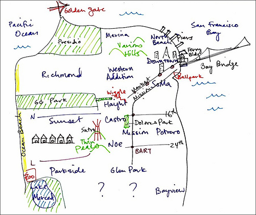 Image: Yo-Sheang Cheng/Visualizing Mental Maps of San FranciscoSeizing on that possibility in immensely creative ways, the UC-Berkeley project “Visualizing Mental Maps of San Francisco” has produced map images that provide fascinating new insights about places we previously thought were entirely familiar.
The best thing about this project — directly responsible for its power to help us think in new ways — is that it uses both highly subjective skills such as sketching places from memory (thus, presumably, the “mental” part of Mental Maps) and very precise technology such as GIS. The idea is to represent the city not in the standardized way of, say, Rand-McNally, but in the various ways that people actually experience it. Fabin Neuhaus describes the project in The Sustainable Cities Collective:
The great aspect [of] this project ‘Visualizing Mental Maps of San Francisco‘ by Rachelle Annechino and Yo-Shang Cheng is how they allow room for the method to breathe the uncertainty of its nature. Mental Mapping is not about accuracy and precision, or truth and objectivity, and to combine this with GIS or mapmaking is a very difficult task [if] not to say impossible.
The essential thing is to give the playfulness a meaning and find a balance for mapping it in GIS. With this project it is not achieved in the detail, but in the overall construction, how the different sections combine and the picture the presented result paints.
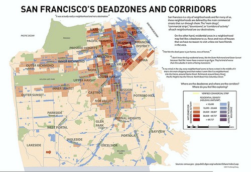 Click for a larger version.Image: Visualizing Mental Maps of San FranciscoIn this post I show see three intriguing examples from the project:
- A memory sketch of neighborhood locations in San Francisco, above (note the author’s question marks in the southern part of the city).
- A second map of neighborhoods (right), this time illustrating the degree of neighborhood completeness represented by the presence of commercial and mixed-use streets. The map also illustrates the relative absence of completeness in “dead zones” of residential areas with little in the way of shops or services nearby. Places zoned for commercial activity are shown in shades of blue, light to dark according to relative population density, while places not allowing commercial activity are shown in shades of brown. (Click on the map for a larger version showing more of the detail.) Note that there are some very dense places (dark red/brown) that lack commercial zoning. It would be interesting to compare this map with Walk Score’s composite map of San Francisco, showing how that service’s scores (which measure nearby shops and services) are distributed across the city.
- For me the most intriguing is a map (below) showing the location of pedestrian barriers such as high-speed roads and steep slopes, marking potential boundaries between neighborhoods.
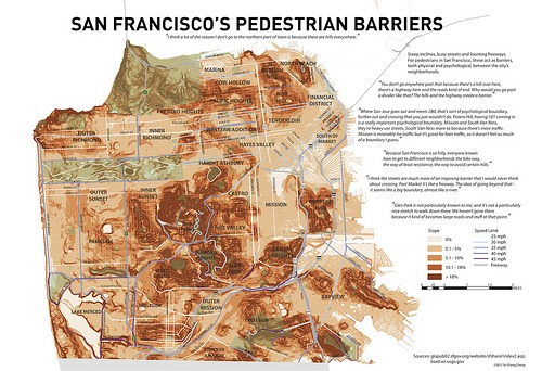 Click for a larger version.Image: Visualizing Mental Maps of San FranciscoThe cartographers themselves put it this way:
The Visualizing Mental Maps of San Francisco project taps into San Francisco residents’ perceptions of the city and its neighborhoods, which aren’t always reflected in the geography of a street map. The first part of the project was a qualitative investigation in which we interviewed residents and asked them to draw pictures of their internal images or ‘mental maps’ of the neighborhoods they lived in and of San Francisco. The second part was the creation of visualizations informed by the qualitative research, resulting in this atlas of mental maps.
Every map has a perspective, and every map is ‘wrong’ in some way … A precise, accurate map asks us to believe that we know what a place is called, what its borders are, and where it belongs within a standardized hierarchy of space. But do we really know all those things? From whose perspective?
Some of the maps on the site are interactive.
Beyond the UC-Berkeley project, neighborhood mapping may be inherently more art than science. For some alternative approaches, see Aaron Renn’s recently completed neighborhood map of Indianapolis on his blog The Urbanophile. Like Steve Mouzon and the Mental Maps duo, Aaron refers to the usefulness of naming places. He also references one of his influences, the neighborhood maps of Chicago and other cities by Jenny Beorkman for her enterprise Ork Posters. To those I might also add Mary Belcher’s colorful neighborhood map of Washington, D.C.
4. Paint them
If yo
ur instincts are more inclined toward the subversive, you may be drawn (heh) to the work of the Toronto Urban Repair Squad, which paints bike lanes on city streets where they think they should be, regardless of whether the city agrees. A similar group in Mexico City paints pedestrian walkways and crossings:
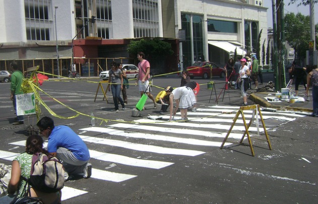 Photo: Diego Enrique Hernandez Gonzalez
Jimena Veloz writes in This Big City:
When governments don’t build infrastructure, citizens usually complain, but can’t do much about it. They pressure public officials and protest against proposed projects, but that’s as far as citizen participation in city building usually goes. It’s reactive, not proactive.
However, this model of citizen participation is being rethought by citizens around the world. They are taking control over what happens in their cities. They are helping to build them, mostly with paint. Local groups all around the world are taking the initiative and are building the infrastructure that governments refuse or are slow to do.
The Urban Repair Squad has a simple motto: “They say city is broke. We fix. No charge.” The group in Mexico City (Camina Haz Ciudad) has been successful in getting their city to take action in the places they have brought to public attention. Additional groups reportedly have formed in Los Angeles and Victoria, B.C.
5. Envision them with graphic facilitation
The last idea for today came to me via Joel Mills, director of the American Institute of Architects’ Center for Communities by Design. Joel and his colleagues administer a program that sets up charrettes (collective brainstorming sessions that assist planning) to help communities work through challenges that might be helped by intensive, condensed architectural thinking and planning. This requires a range of skills, as many of you know and others can well imagine. One of them is listening to the voices of the community and helping them synthesize their thoughts.
This is where Julie Stuart’s firm Making Ideas Visible comes in. You know those meetings where people have flip charts on which facilitators scribble down what they hear (frequently getting it almost but not quite right), and then tape the various pages all over the walls? I guess some people find that useful, but I’ve always thought that there has to be a better way.
There is. Take Stuart’s summary of ideas for a green corridor in Santa Rosa, Calif. The soccer field is represented by a ball heading into the net; alternative energy by solar panels on a roof; there’s a dog to represent the dog park, a playground, a garden, and so on. These sketches are not artistically sophisticated or precise. That’s not the point; they must be done quickly. But they bring ideas alive in a way that words alone cannot (recalling Chuck Wolfe’s photographic urban diaries at the top of this post), and the format alleviates the mind-numbing boredom that can accompany some of these flip-chart meetings. My guess is that they make the process of imagining better communities just a bit more stimulating and fun.
You can visit the website of Making Ideas Visible here.
So there you have it for today. For me, each of these exercises brings a fresh perspective, enabling me to see and understand a neighborhood or a city in a different way. A more purposeful and, ultimately, more mindful way. I’m sure there are five, or 50, additional great ways in which we can see our communities anew and add to the accumulated truth that we know about them, as well as about our aspirations for making them better. I’ll get to more of them over time, no doubt. In the meantime, I am grateful for the artists and thinkers that have led me, and now you, to these.
