On a sunny Friday in late May, a jubilant wedding party scrambled to the top of a colossal sand dune in this tiny Dutch beach town for a photoshoot, bridesmaids’ arms flailing as their high heels sunk in. The wedding ceremony had just ended at an outdoor venue nestled behind the six-story mountain of sand, which blocked the view of the North Sea.
At the town’s main strip nearby, a mostly older crowd sipped beers and wine and nibbled on ice cream cones. No one seemed to mind that they couldn’t see the water.
Unlike in the United States, such obscured ocean views are common in the Netherlands, where people aren’t allowed to build homes or businesses directly on the coast — and for good reason. Three of Europe’s major rivers run through the compact country on their way to the ocean, and almost one-third of it lies below sea level, making it extremely vulnerable to deadly storm tides.
The dunes in Noordwijk are part of a world-renowned storm defense system that covers the entirety of the Netherlands’ coastline — much of it hefty enough to protect against a monster, 10,000-year storm. The system has become a beacon for Texas as it looks to guard the eastern flank of the low-lying Houston-Galveston region — home to millions of people and the nation’s largest petrochemical complex — from hurricanes. Despite its vulnerability to deadly storm surges, the upper Texas coast has no comprehensive storm protection system.
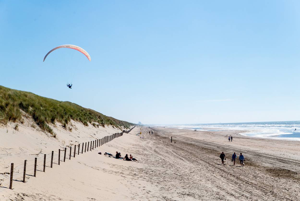
The dunes near the Langevelderslag beach in Noordwijk are 65 feet high and more than a mile wide, and they can protect against a 10,000-year storm. David Zacek / The Texas Tribune.
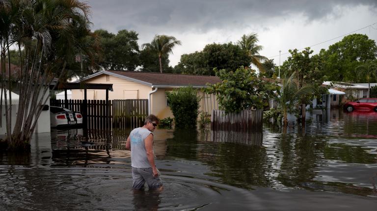
That vulnerability became apparent after Hurricane Ike in 2008, when scientists warned that the storm — the costliest to ever hit Texas at the time — could have been much worse for the Houston-Galveston region if it hadn’t changed course at the last minute. And although 2017’s Hurricane Harvey made landfall much farther down the coast, its torrential rains put large swaths of Houston underwater and drove home the widespread damage a hurricane could inflict on the nation’s fourth-largest city.
The Netherlands experienced a similar reckoning after a freak storm in 1953.
That North Sea flood, which the Dutch simply call “the disaster,” breached neglected and war-battered dikes, inundated an area bigger than the city of Houston and drowned more than 1,800 people — a death toll nearly identical to that of Hurricane Katrina after it swamped New Orleans and parts of Mississippi. Within weeks, a special Dutch commission initiated a sweeping public works program that it vowed would keep the country dry forever.
“The 1953 flood was a wake-up call,” said Marcel Stive, a hydraulic engineering professor at the Delft University of Technology. “While the economy was resurrecting and doing well [after World War II], the public and politicians realized our vulnerability.”
The Delta Works, later declared one of the “Seven Wonders of the Modern World” by the American Society of Civil Engineers, surrounded a fifth of the country’s population with an ingenious combination of dams, dikes, locks, and first-of-their-kind storm surge barriers. It took decades to finish it all — much longer than expected — but the first project was completed just five years after the storm.
In the 66 years since the disaster, no Dutch citizen has died in a flood. In Texas, hundreds of citizens have perished in floods and hurricanes just in the past two decades.
Flood risk has remained so low in the Netherlands that homeowners don’t buy flood insurance and building codes behind the flood barriers are virtually nonexistent.
The Netherlands has remained mostly dry for so long that polling shows a majority of citizens have little idea that their country is livable largely because of masterful water management — an unintended side effect that Dutch officials are trying to address for fear that people won’t support future flood control efforts.
After engineering what they tout as “the safest delta in the world,” the Dutch have ramped up the export of their expertise; they have advised several U.S. states and other coastal areas around the world on protecting lives and property from storms and rising sea levels.
Bill Merrell, an outspoken oceanographer at Texas A&M University at Galveston, began preaching the Dutch gospel after Ike.
In early 2009, just a few months after the storm, he introduced a concept dubbed the Ike Dike that became his personal crusade. It included storm surge barrier gates and dozens of miles of dune-topped levees. He insisted it was the best way to keep the next big hurricane from inundating hundreds of thousands of homes and potentially shuttering the massive industrial complex along the Houston Ship Channel, which produces about 13 percent of the nation’s gasoline and nearly 30 percent of its jet and diesel fuel. The Ike Dike mirrored the Dutch concept of stopping storm surges right at the coast to provide maximum protection.
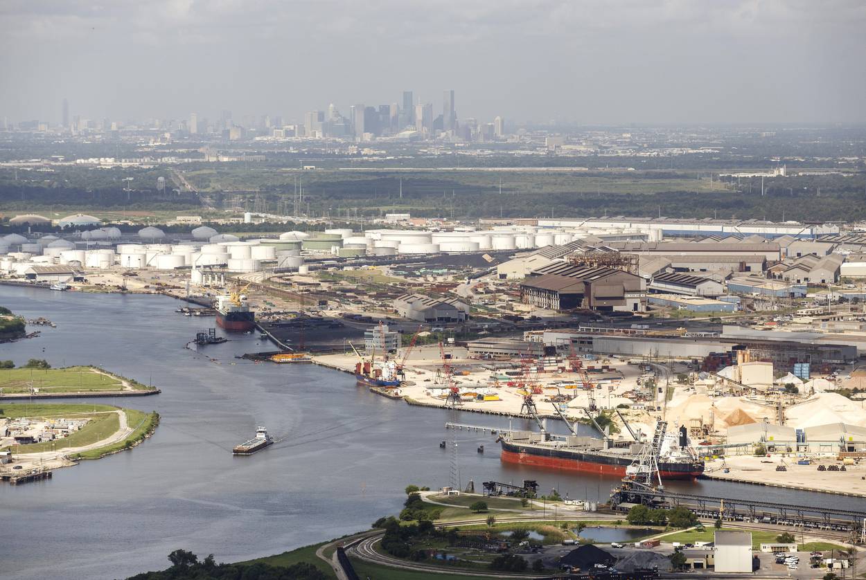
The industrial complex along the Houston Ship Channel in 2016. Michael Stravato / The Texas Tribune.
Now, a decade later, the U.S. Army Corps of Engineers and the Texas General Land Office are moving ahead with a plan that would do just that. A coastal barrier system — part of a coast-wide protection plan estimated to cost as much as $32 billion — is still in the early stages; the agencies have made significant revisions in recent months after receiving thousands of public comments opposing the initial vision, mainly because it would have left thousands of homes and businesses stranded on the exposed side of a proposed system of levees and required the condemnation of a significant number of buildings.
Those changes have made it look even more Dutch, with 12-foot-high sand dune-topped levees — the preferred term for dike in the United States — meant to protect beachfront homes and businesses and a redesigned storm surge barrier system aimed at being more failproof and environmentally friendly.
The plan, which the agencies will put out for a second round of public comments in September of next year, is set to be finalized in 2021. Getting buy-in from locals is the first of many obstacles it will face.
As the government moves forward with the project, The Texas Tribune traveled to the Netherlands to learn about how the Dutch pulled off such an ambitious coastal protection project and how the Netherlands’ model could help guard the Texas coast.
“The Dutch have faced storm surge and flooding as an existential threat to their country for centuries,” said Texas Land Commissioner George P. Bush, who heads the General Land Office, the state agency that oversees the coast.
As a result, most Dutch citizens don’t question sizable government spending on flood control or complain about paying higher taxes — about $119 annually per household — to maintain a system that has protected them from the sea for generations. It’s a mentality that stands in stark contrast to the United States, where many elected officials are staunch champions of smaller government and lower taxes.
If completed, Texas’ coastal barrier would become just the second coastal protection system in the United States, after New Orleans’ revamped levee system, and the largest that the Army Corps has constructed in its 200-year history — so large it would be visible from space.
Selling the Texas project to members of Congress from inland states that don’t face similar threats will be difficult, Bush acknowledges.
“We can’t rely on near misses and hopes to defend the coast,” Bush said. “At least for my time here, I’m going to be focused on this and I’m not going to rely upon another storm to try to get funding. I’m going to do what I can within my power.”
Then there is the question of which local entity would pay to maintain the coastal barrier. Once the Army Corps is done with a project, it typically hands over the keys and walks away.
“There are multiple possibilities of failure in this,” Bush said. “Our focus has to be on just taking it step by step, not losing sight of the big picture.”
A ticking clock
The first time Dutch flood-control experts visit Galveston Island, they are always shocked to see homes and businesses perched next to the water — no levees, dunes or gates of any significance to guard them.
“In the United States, it’s like, ‘I want to have a view, I want to see the sea from my house, so I’m going to build on the beach,’” said Jeroen Aerts, director of the Institute for Environmental Studies at Vrije Universiteit Amsterdam. “It’s completely different in the Netherlands.”
Many Dutch officials say that mindset reveals the biggest differences between the countries: Americans are more self-reliant — and their properties are most often insured — so federal and state government focus on emergency response and cleaning up after a natural disaster much more than preventing the damage.
But with so much at stake on the Texas coast — millions of lives, billions of dollars worth of property, and many of the nation’s biggest fuel and chemical producers — some state officials have pushed to break that mold.
In a worst-case scenario hurricane, storm modeling shows that part, if not all, of the facilities lining the Houston Ship Channel would be inundated, along with hundreds of thousands of homes and businesses and the Johnson Space Center, home to NASA. And as the climate warms and the population grows, scientists warn, the threat of such a hurricane is becoming greater.
“Sea level is rising, the storms are getting larger, and the clock is ticking,” wrote Jim Blackburn, codirector of Rice University’s Severe Storm Prediction, Education and Evacuation from Disasters Center, in a recent white paper.
Over the years, Blackburn also has hammered that the impact of a worst-case storm on the industrial complex — in addition to economic calamity — could lead to one of the biggest environmental disasters in U.S. history. Storm modeling shows that a major surge could impact thousands of industrial storage tanks near the Houston Ship Channel that hold crude oil and hazardous chemicals; if even one ruptured, scientists say, the toxins could inflict irreparable harm on Galveston Bay, one of the region’s most productive estuaries and a national ecological treasure.
To help prepare for that storm, scientists and students at A&M at Galveston and Rice have spent years studying a country that was unprepared for its own worst-case scenario six decades ago.

Mina Verton holds up a photo of her family’s farmhouse, which was swept away in the 1953 North Sea flood. Thana Faroq / The Texas Tribune.
The disaster
It was about 5 a.m. on February 1, 1953, when two of Mina Verton’s cousins hammered on the front door of her family’s stone farmhouse on the rural island of Schouwen-Duiveland in the southwestern Netherlands. It had been storming all night. Surges had breached nearby dikes, they said, and the island was sure to flood.
The home had been inundated during a dike breach before, during World War II, when the Nazis bombed Dutch flood defenses as the country resisted occupation. The water had topped out at about a foot and a half then — and that’s what they expected would happen again.
But when it finally arrived, the icy water quickly blew past that point. In less than an hour, it swallowed the ground floor of the house and moved on to the second. The family climbed out windows onto the roof. It was freezing cold and still raining.
At around noon, terrified neighbors began to float by on scraps of wood. The family thought they were safe on the roof, but their sturdy stone house eventually gave way to the strong current.
They partly jumped, partly swam to the roof of a nearby storage shed, which soon broke apart; Verton, her mother and sister were on one piece, her father and brother on two others.
“You could hear people drown,” Verton said through a translator.
Verton, then 12, held her 5-year-old sister in her lap and prayed. They floated on the scrap of roof for another 24 hours, until it bumped into a still-standing dike that they wearily climbed onto.
In the end, 1,836 people lost their lives. Verton lost her brother, grandmother, several aunts and uncles, and a cousin. Her grandmother was never found; she was either swept out to sea or buried as an unidentified victim.
When they finally returned to the island more than a year later, there was nothing left of their farm.
No one talked about the disaster for decades after, including Verton. That was in part because it was so traumatic, but also because many people in the region, part of the country’s “Bible belt,” viewed the flood as the hand of God.

Mina Verton looks through a scrapbook of family photos at her home in Zierikzee. Thana Faroq / The Texas Tribune.
But a hydraulic engineer had warned of the likelihood of such a tragedy.
In fact, just a day before the storm hit, Johan van Veen presented a plan to his superiors at Rijkswaterstaat — the Dutch equivalent of the Army Corps of Engineers — to fix the aging dikes in the region. His warnings had gone unheeded for some 15 years amid the Great Depression, which had started in the U.S. before battering Europe, and World War II.
“The ’30s and the ’40s weren’t exactly years you would think about doing something extra — staying alive was No. 1,” said Stive, the hydraulic engineer at the Delft University of Technology.
The disaster was a huge blow to the reputation of Dutch hydraulic engineers, who fancied themselves the world’s leading water wranglers. In 1920, they had broken ground on a long-envisioned public works project that wielded new technologies to guard thousands of acres of vulnerable coastline in the northwest, created a freshwater lake, and reclaimed hundreds of thousands of acres from the sea for agriculture and development.
In a 2006 essay, Dutch social scientist Cornelis Disco explained the national dismay that followed the flood’s devastation: “That the Netherlands should have been so unprepared for such a devastating storm surge did not fit the image of the nation as indomitable master of the flood.”
Clogs, canals, and windmills
Three of Europe’s major rivers run through the heart of the Netherlands — Dutch for “low country” — on their way to the North Sea, and a fourth snakes through the country’s far north. Along its 280-mile coastline, the notoriously stormy sea is capable of hurling deadly swells into the country for days at a time.
The first dikes were built in the Netherlands in the early Middle Ages by wood-clog-wearing settlers keen on farming the soggy but fertile delta.
Eventually, local water authorities took over construction and management of the country’s growing flood control systems. They were the first democratically elected institutions in the Netherlands — some say the first in Europe — and they spent centuries creating a vast network of dikes and canals, along with thousands of the now-iconic squat windmills to pump water through them.
The country’s geography has been transformed over the centuries as the sea has swallowed and spit out land at will, and the Dutch have clawed much of it back. By surrounding submerged land with dikes and pumping out the water, the Dutch created hundreds of thousands of acres of farmland and set the stage for a country that’s about 16 times smaller than Texas by square mileage to become the world’s second-largest exporter of agricultural products after the United States.
But the dikes didn’t stop the North Sea, which regularly unleashed devastating floods that have drowned thousands of Dutch citizens.
As early as the 17th century, hydraulic engineers envisioned large-scale public works projects to shield the country from the sea. But the technology didn’t exist to pull it off. That changed early in the 20th century with the Zuiderzee Works, which brought the construction of major dams and dikes to the northwestern part of the country. Its most iconic component was the Afsluitdijk, a 20-mile-long causeway that severed the Zuiderzee, a large, shallow bay, from the Wadden Sea. The Afsluitdijk, which remains a point of Dutch national pride, was completed in 1932 and turned the Zuiderzee into a freshwater lake that remains one of the Netherlands’ largest drinking water supplies.
The Zuiderzee Works put the Dutch on the map as innovators in storm management and made the knowledge of the country’s hydraulic engineers a valuable export. But it wasn’t enough, and the ’53 flood proved that.
They needed to respond in a big way, and quickly.
‘God created the earth, but the Dutch created the Netherlands’
Just two weeks after the flood, a new entity called the Delta Commission convened to hatch plans for what would become the country’s largest flood defense system. It would be expensive — a tough sell in a country still reeling from the war — but the commission vowed that it would stop flooding for good.
Thanks to van Veen, the engineer who had warned of the country’s vulnerability to flooding, the commission had rough blueprints. But it ultimately went beyond those plans, constructing three locks, six dams, and five first-of-their-kind closable storm surge barriers made of metal and concrete. They effectively sealed off the entire southwestern coast, ground zero for the ’53 disaster, blocking storm surges from entering the inlets where the Rhine, Maas, and Schelde rivers emptied into the North Sea.
By the time the Dutch finished the Delta Works, 44 years after the disaster, they had accomplished something the International Federation of Engineers declared “the most prestigious hydraulic engineering project in the world.” Two of the projects were declared national monuments.
The Delta Works, which cost upwards of $11.4 billion in today’s dollars, became part of a 2,300-mile system of natural and manmade barriers that now corset the major rivers, lakeshores, and sea and guard 100 percent of the Netherlands’ coastline. Another 8,700 miles of barriers sit inland. Without them, more than 60 percent of the country would flood every day.
How the Netherlands stops flooding
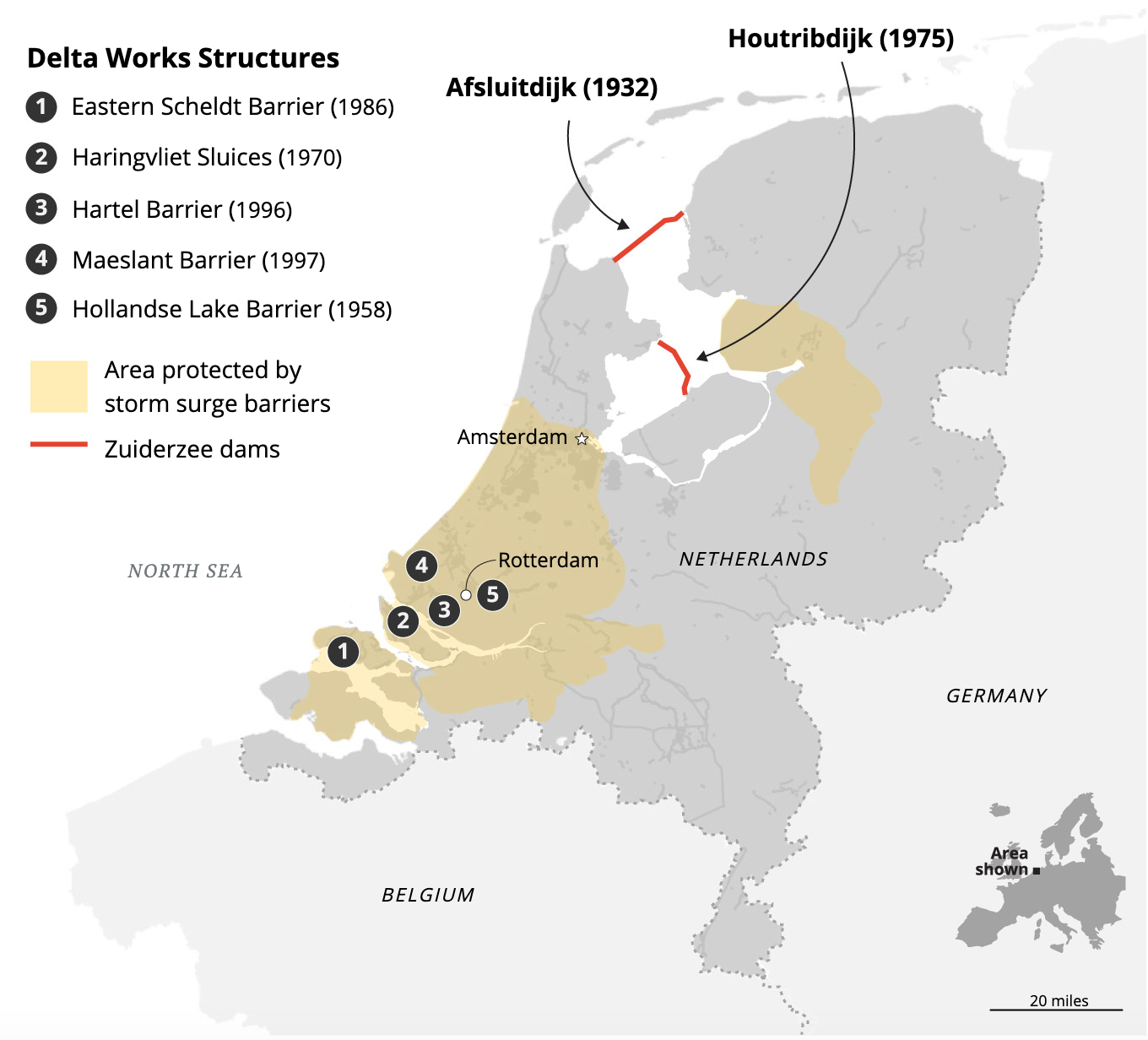
Source: Rijkswaterstaat. Credit: Connie Hanzhang Jin.
At some point during all of this, a saying emerged: “God created the earth, but the Dutch created the Netherlands.”
Today, only about 100,000 of the country’s more than 17 million citizens don’t live behind some kind of flood barrier, and they’re responsible for repairing any flood damage to their property. Everyone else who lives behind the dikes must be made whole by the government if their homes are ever inundated, something that’s only happened once since 1953, when a drought-weakened dike burst in 2003 and flooded hundreds of homes.
“Any [flood] impact, in their minds, is failure,” said Samuel Brody, director of the Center for Texas Beaches and Shores at Texas A&M University at Galveston, one in a team of researchers that has traveled to the Netherlands to gain flood control wisdom it has incorporated into its own proposed Houston-Galveston coastal protection system.
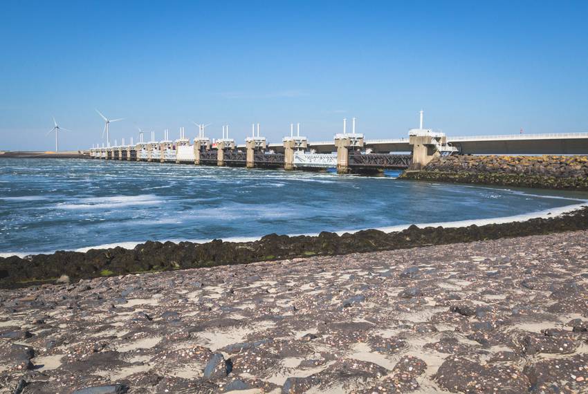
The 33-year-old Eastern Scheldt Barrier, made up of 65 giant pillars separated by vertical gates, is the largest of the Delta Works projects. Thana Faroq / The Texas Tribune.
The Ike Dike
Texas may have its own Johan van Veen in Merrell, the A&M Galveston oceanographer who has spent the past decade warning of a coming disaster and trying to convince the government that he has a solution.
In early 2009, just a few months after Hurricane Ike devastated the Houston-Galveston region, Merrell introduced the Ike Dike.
That year, he traveled to the Netherlands to get advice on how to hone the plan, which consisted of beachfront earthen levees topped with sand dunes along the entire lengths of Galveston Island and Bolivar Peninsula, plus a gate system between the landmasses and another gate system on the far end of Galveston Island near San Luis Pass. He included a “ring” levee around the city of Galveston to protect it from incoming and outgoing surges.
After Merrell returned to Texas, he peddled his plan to state and local elected officials as well as local civic and business groups, arguing that his beachfront system was superior to one further inland — a concept that had been proposed by Rice University researchers — because it would protect everyone.
Locals loved the concept, but politicians were not so convinced, at least at first.
In2015, the Army Corps and Texas General Land Office launched a study to find the best solution. Last October, the agencies proposed a plan that would build 17-foot-tall levees on the backsides of the main roadways on Galveston and Bolivar and install 39 vertical storm surge gates in the waterway between them— plus a single large gate over the deepest part of the pass where ships travel. But after receiving some 6,000 public comments expressing outrage that thousands of homes and businesses would be stranded on the ocean side of the levees, the agencies have revised the plan to look a whole lot like Merrell’s Ike Dike.
How the government wants to guard the Houston area against hurricanes
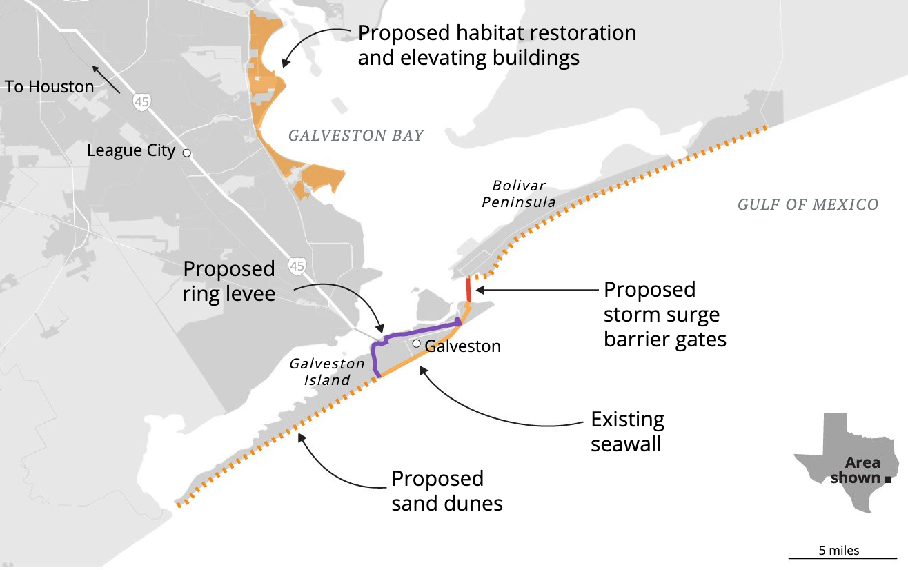
Source: Coastal Texas Protection and Restoration Feasibility Study, Texas General Land Office. Credit: Connie Hanzhang Jin.
“They’re going to end up with our original concept,” Merrell said in a recent interview. “It was the right concept. I’m more and more convinced of that, and, of course, the Dutch helped us do it.”
The overarching vision follows the Dutch approach of blocking storm surges right at the coast with a combination of hard and soft infrastructure.
But the plan remains controversial. The Galveston business community says the proposed ring levee would hinder cargo and passenger loading at the Port of Galveston, a key destination for major cruise ships. And environmentalists worry that a gate system between Galveston and Bolivar to block storm surges — the most important, expensive, and complex component of the plan by far — would hinder an exchange of saltwater and freshwater between Galveston Bay and the Gulf of Mexico that is crucial for marine life.
Kelly Burks-Copes of the Army Corps’ Galveston District, who is managing the project, said the agency is now considering a shorter, less intrusive ring levee. And Dutch engineers are helping the agency figure out how to make the gate system less ecologically disruptive. One solution is to swap the lone deep-draft gate for two smaller ones, which would have another benefit: If the lone gate failed, it would halt ship traffic in one of the nation’s busiest ports; installing two gates would reduce the odds of such a major disruption.
Still, the gate system is a critical piece of the plan.
“Our storm modeling so far says 60 to 65 percent of the risk reduction is achieved with a gate across the inlet alone,” even in the face of extreme storms, Burks-Copes said.
Army Corps leadership has given the Galveston District unprecedented leeway as it designs such an extraordinary project. Typically, districts are only given $3 million and three years to complete plans; the Galveston District has $20 million and five years.
While the government is finally moving ahead with a plan after many years of foot-dragging and debate, Merrell says he still sees a lack of political will to turn the plan into reality.
“I don’t know if we’ll find it or not,” he said. “In the Netherlands, they have political will to protect — it’s part of their culture — and we really don’t. We’d rather pay the money afterwards. … To protect is a much harder thing for our political system to deal with.”
The century’s largest engineering project
Congress found the will to pay for a $14 billion overhaul of a storm risk reduction system in New Orleans that the Army Corps broke ground on shortly after Katrina. The aftermath of Hurricane Harvey seemed like the perfect political moment to get federal funding for Texas’ coastal barrier project.
But the project wasn’t eligible for construction funding because the Army Corps and General Land Office hadn’t finalized the plan. Instead, Congress gave the agencies $1.9 million to finish the design and put up $4 billion for a less high-profile component of the coastwide protection plan that calls for the construction and rehabilitation of levees near Port Arthur and Freeport that would flank the coastal barrier system.
Blueprints for the project aren’t expected to be finalized until 2021. After that, it will get in line with dozens of other projects across the country awaiting funding.
The original version of the coastwide project, which includes extensive beach nourishment wetland restoration and other natural storm surge barrier absorbers on the lower Texas coast, was estimated to cost between $23 billion and $32 billion, with the Houston-Galveston coastal barrier system making up as much as $20 billion of that. Burks-Copes said she doesn’t expect that estimate to change significantly.
Bush, the Texas land commissioner, said he prays that if a big storm does come, it will hit after 2021 — when the plan is eligible for funding. But even then, he worries about Congress’ willingness to back it.
Earlier this year, he pleaded with state lawmakers to put up the entire $1.4 billion local match that Texas needs to send to the federal government to draw down the $4 billion Congress approved last July for the levee project. (The federal government typically pays 65 percent of the cost of such major public works projects.) They ended up funding only $200 million — even as they left $9 billion in the state’s emergency savings account, known as the rainy day fund.
If Texas doesn’t show serious financial commitment for a smaller project that’s already in the pipeline, Bush said, Congress and the Army Corps might not be up for funding the much larger one for the rest of the Texas coast.
“The corps has made it clear that if we do not move forward with the local match on that project, then it complicates matters for the coastal barrier system,” he said.
Even in a best-case scenario, the project won’t be completed until 2035. Burks-Copes said it will likely take far longer than that.
“This will be the largest engineering system built in this century,” she said, noting that the Army Corps’ entire annual budget is only about $5 billion. “In all likelihood, we’ll probably receive incremental funding, and we’ll have to build this component by component.”

Students from Texas A&M, Rice and Jackson State universities get a tour of the Maeslantkering. Thana Faroq / The Texas Tribune.
‘Not just for fun’
On a cold, cloudy afternoon in mid-May, a group of students from Texas A&M and Rice universities ogled the Maeslant Barrier, posing for photos under one of its mammoth gates.
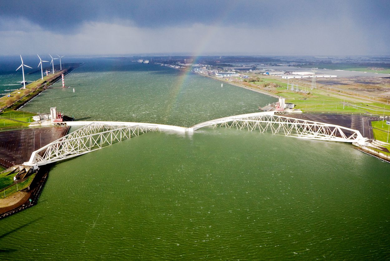
Completed in 1997, the Maeslant is the fifth and last major storm surge barrier to be built in the Netherlands and the one the Army Corps and General Land Office are looking to for inspiration as they fine-tune their proposed storm surge barrier gate system.
The Maeslant consists of two vertical, fan-shaped gates — each about the length of two football fields — perched on either side of the ship channel that leads to the Port of Rotterdam, Europe’s largest port. They remain open in normal weather conditions. When supercomputers detect a significant rise in sea levels, the gates swing shut automatically on ball-and-socket joints.
They have been closed only twice in 22 years.
A Rijkswaterstaat official wearing a bright orange safety vest and matching hard hat explained to the students that the barrier is meticulously maintained, built to withstand a 10,000-year storm and capable of holding back a storm surge of more than 16 feet.
When Dutch officials were asked to help design a multibillion-dollar overhaul of the New Orleans levee system after Hurricane Katrina, he said, they thought the Americans were joking when they said they would design it to withstand only a 100-year storm. (The Army Corps has acknowledged for years that it is not protective enough and is now looking at ways to strengthen it in the face of faster-than-expected ground subsidence and sea-level rise). The Dutch have passed a law requiring that coastal defenses be designed to withstand a storm surge that occurs every 10,000 years on average.
“It’s not just for fun,” said Harold van Waveren, principal flood safety expert at Rijkswaterstaat. “We have a lot to protect.”
The current system is expected to be sufficient until at least 2050. Still, the Dutch are feverishly preparing for a warming planet — and thinking beyond big public works projects to do it.
Stronger than God?
Sitting at a communal table in a breezeway at the Rijkswaterstaat headquarters in Lelystad, van Waveren pointed to his laptop screen. It displayed a picture of a charming Dutch cottage atop a large, grassy mound — a “terp.”
This was what the Netherlands looked like 2,000 years ago, he explained, before the Dutch started bending water to their will. When floods would come, people would simply retreat to their homes and wait them out.
That changed with widespread construction of dikes and polders — land reclaimed from sealed-off bays — and the sense that water had been fully mastered.
“We were stronger than God — we thought,” said van Waveren, who also chairs the National Coordination Committee for a flood threat. “We were wrong.”
In the past few decades, that approach has come back “to bite the Dutch in the heels,” said Amsterdam-based journalist Tracy Metz, an American expat who authored the book Sweet & Salt: Water and the Dutch.
And the Dutch say that’s thanks largely to climate change.
The implications of a warming planet landed firmly on the Dutch’s radar in 1990, when the initial assessment report by the Intergovernmental Panel on Climate Change established that manmade carbon emissions are the primary driver of the warming trend and that sea levels would rise significantly every decade over the next century unless emissions were significantly cut.
Then came two near-floods a few years later, which shocked many citizens because the threat came not from the sea, which had always been the biggest enemy, but from the rivers. Upstream development was partly to blame, but so were sea-level rise and increased rainfall.
That was succeeded by the 2003 dike breach, the 2004 Indian Ocean earthquake and tsunami in southeast Asia, and Hurricane Katrina in 2005 — all of which sparked further introspection in the Netherlands. Former U.S. Vice President Al Gore’s 2006 film, An Inconvenient Truth, topped it all off. It highlighted the Netherlands as particularly vulnerable to climate change.
Global warming has reared its head in other ways since then. With sea-level rise, for example, the soil has become much saltier — a huge threat to agricultural production.
The Dutch began to ask themselves, “Is there really a plan B if the whole foundation on which this system is built turns out to be not future proof?” Metz said.
Metz served on a second Delta Commission convened in 2007 to explore that issue. Its mission: to ensure the country is protected from floods through 2100 and beyond. Its recommendations did not involve more steel and concrete, but rather validated an approach that was already underway.
The Room for the River project, as its name implies, aimed to give the rivers — which had been narrowed, reversed and girdled by dikes and development over the decades — room to swell during floods. Launched in 2006 and completed this year, the $2.5 billion program has brought home buyouts, dredging and other measures, including breaking down dikes that had kept some areas dry and returning that land to the rivers.
It’s designed to help the Netherlands withstand rain-based flooding in addition to storm surges, though Dutch officials note that during a storm like Harvey, which was a 500-year event, their country would flood, too.
While hulking dikes and storm surge barriers will always be an important part of the Dutch’s flood control equation, van Waveren said, “Now, we’re going back to the original strategy of our grandparents to work with nature instead of just fighting.”
Is it enough?
Even if the Texas coastal barrier comes to fruition, some fear the Army Corps’ plan may not be enough to protect lives and property from a worst-case hurricane.
While the agency runs hundreds of storm models to settle on the best design, Blackburn, codirector of Rice’s disaster center, contended in his recent white paper that the plan has a major flaw: It’s designed to withstand an average, rather than an extreme, storm.
“It is worrisome that the U.S. Army Corps of Engineers would recommend a project costing $14 billion to $20 billion that does not protect the region from a larger storm that is certainly foreseeable,” he wrote.
But Burks-Copes said Army Corps regulations — which require the agency to weigh the costs of a project against the likelihood of the worst possible threat — don’t allow it to “cherry-pick” the storm it designs to.
“We don’t just plan for one storm,” she said. “We’re planning for a broad range of types of storms.”
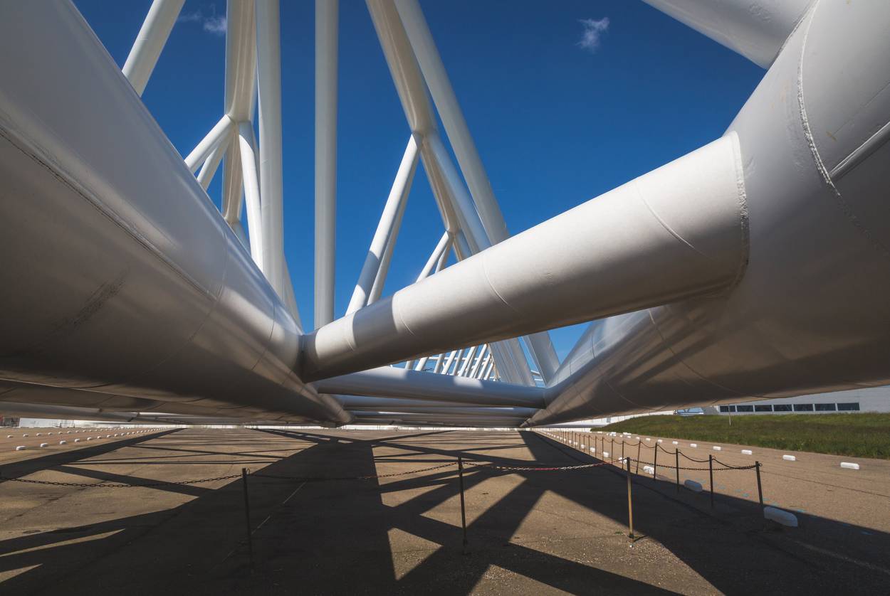
A close-up of the Maeslantkering, which is in the Hook of Holland. Thana Faroq / The Texas Tribune.
As far as the eye-popping price tag of the project — equivalent to the estimated cost of NASA’s planned moon landing — Burks-Copes emphasized that Harvey and Ike each inflicted tens of billions of dollars in damage. That means this project would pay for itself in one storm, she said.
Another concern: Texas — unlike the Netherlands — faces hurricanes, and some experts say that means the Army Corps needs to build the barriers even higher than the Dutch did to get the same level of protection.
Bruce Ebersole, a former longtime Army Corps engineer who is now a researcher at Jackson State University in Mississippi, said Gulf Coast hurricanes can generate higher surges than North Sea storms can, though they don’t last as long. That means levees have to be taller to prevent overtopping — or, if it’s a sand dune system, much wider — and that could add to the price tag. It also means that the Netherlands’ defense system can’t simply be copied along the Texas coast.
“Water levels and wave conditions are just higher than they are in the Netherlands,” said Ebersole, who has consulted on the Ike Dike.
Considering that, Ebersole had expressed concern over the Army Corps’ initial plan to install sand dunes without any kind of armored structure underneath them, such as compacted clay levees. The corps has since changed course based on input from Ebersole and other researchers, Burks-Copes said, noting the plan is still very fluid and likely will change again in the coming months.
Still, preliminary modeling shows the dunes would likely protect against only a 100-year storm.
Aerts, the Vrije Universiteit Amsterdam professor, said designing for a 100-year storm is probably fine for Texas as long as it sufficiently accounts for climate change and allows for adaptation if weather patterns change more rapidly than initially predicted — something Burks-Copes said the agency is doing.
That can be difficult in a country where climate change denial has gained traction among those in power, but Aerts said that he’s learned one thing about Americans after working in the United States for more than 20 years.
“A lot of people are skeptical about climate change,” he said, “but if things have to be done, then things get done.”
The Texas Tribune is a nonprofit, nonpartisan media organization that informs Texans — and engages with them — about public policy, politics, government, and statewide issues. Support for this article was provided by the Weather Eye Award, an award given to distinguished local reporters by RiseLocal: a project of New America’s National Network.
Disclosure: Texas A&M University and Rice University have been financial supporters of The Texas Tribune, a nonprofit, nonpartisan news organization that is funded in part by donations from members, foundations, and corporate sponsors. Financial supporters play no role in the Tribune’s journalism. Find a complete list of them here.

