NOAA’s National Climatic Data Center reports:
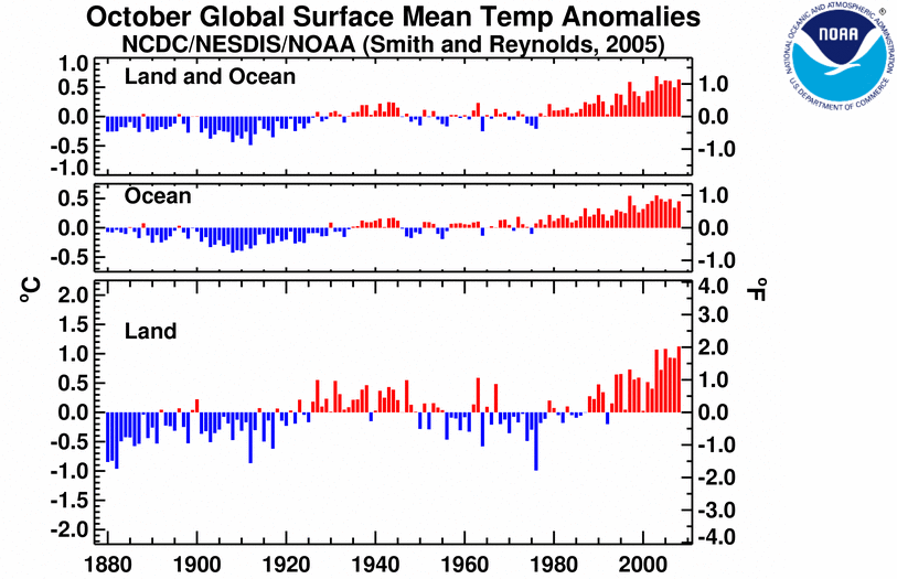
Based on preliminary data, the globally averaged combined land and sea surface temperature was the second warmest on record for October and ninth warmest on record for the January-October year-to-date period.
Given that this report is just out, I’m assuming they have sorted out the data entry issues that briefly caused problems for NASA (see here and here). Also worth noting from the NCDC report:
- According to the National Snow and Ice Data Center, the October 2008 Northern Hemisphere sea ice extent, which is measured from passive microwave instruments on board NOAA satellites, was the third least October sea ice extent on record, behind 2007 and 2006. Average ice extent during October 2008 was 8.4 million square kilometers, which is 9.5 percent below the 1979-2000 average. Sea ice extent for October has decreased at a rate of 5.4 percent per decade, since satellite records began in 1979.
- El Niño-Southern Oscillation (ENSO) conditions remained in a neutral phase during October.
Since interest in the monthly temperature reports is so keen these days, let me repeat the key points from my an earlier post on the monthly data. While the monthly data doesn’t tell us much about the climate, the peer-reviewed scientific literature has a couple of interesting forecasts for the next decade:
- The “coming decade” (2010 to 2020) is poised to be the warmest on record, globally.
- The coming decade is poised to see faster temperature rise than any decade since the authors’ calculations began in 1960.
- The fast warming would likely begin early in the next decade — similar to the 2007 prediction by the Hadley Center in Science.
That is why they call it global warming.
This post was created for ClimateProgress.org, a project of the Center for American Progress Action Fund.
A message from
Your support keeps our climate news free.
Grist is the only award-winning newsroom focused on exploring equitable solutions to climate change. It’s vital reporting made entirely possible by loyal readers like you.
At Grist, we don’t believe in paywalls. Instead, we rely on our readers to pitch in what they can so that we can continue bringing you our solution-based climate news. Donate today to keep our site free.

