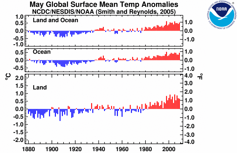
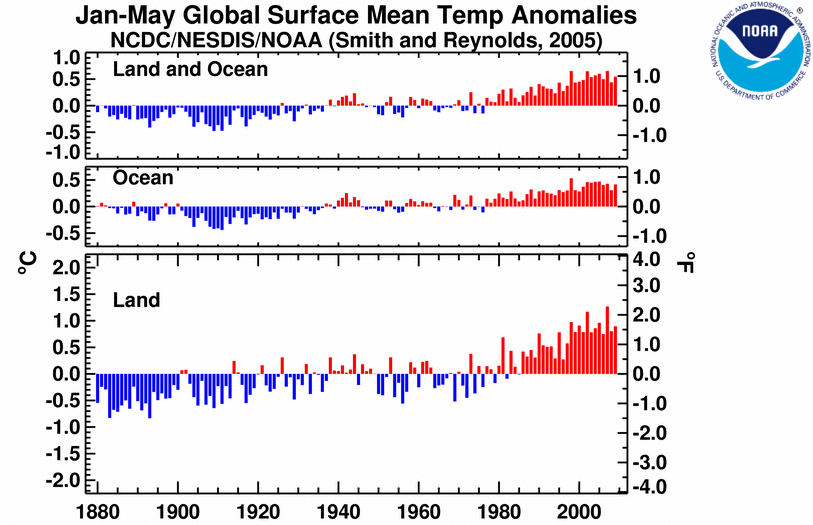
Fast on the heels of the fifth warmest April on record, NOAA’s National Climatic Data Center reports:
Based on preliminary data, the globally averaged combined land and sea surface temperature was the fourth warmest on record for May, the fifth warmest for boreal spring (March-May), and tied with 2003 as the sixth warmest January-May year-to-date period.
And no, I don’t think the monthly data tell us much about the climate. But I know reporting it annoys the deniers. More seriously, the El Niño-Southern Oscillation (ENSO) seems to be heating up, although I’m told it takes a few months before El Niño conditions would translates into warmer global temperatures.
You may recall that earlier this month, NOAA put out an “El Niño Watch,” so record temperatures are coming and this will be the hottest decade on record. This is based on an analysis of all the dynamical models they use to make their forecast:

For clarity’s sake: “El Niño and La Niña are officially defined as sustained sea surface temperature anomalies of magnitude greater than 0.5°C across the central tropical Pacific Ocean. When the condition is met for a period of less than five months, it is classified as El Niño or La Niña conditions; if the anomaly persists for five months or longer.”
Now here is where things get a little interesting. The figure above is the full collection of models they use for their “official” monthly ESNO forecast update. But they also release a weekly update, which “is available to the public to inform their own decisions.” Here is the update of NCEP’s (National Centers for Environmental Prediction) own CFS (Climate Forecast System) model issued with their June 15 weekly update, “ENSO Cycle: Recent Evolution, Current Status and Predictions“:

That would be one big El Niño (and you can read the weekly update to see just how it stacks up against other recent El Niños). I must apply this caveat, which NOAA emailed me:
You’re correct that the CFS is predicting a strong El Nino…. however, it is just one of many dynamical models that we consider when making our forecast. Right now, the CFS predicts the highest amplitude event of all of our models and should be taken in the context of the many forecasts (both dynamical and statistical). Unfortunately, forecasts of ENSO intensity, especially during transitions, are quite tricky. There are some clear-cut cases, such as 1997-98, where there are telltale signals of a strong event. At this point, there is no observational evidence that we are looking at anything approaching the 1997-98 event. At this point, the forecast team is is increasingly confident that an El Nino will develop, but not confident to make a statement about intensity. But please keep reading our weekly and monthly discussions for more insight as about the predicted evolution of the upcoming (probable) El Nino.
So with that caveat in mind, we can very safely say “this will be the hottest decade in recorded history by far,” and also that we might just be looking at the kind of El Niño that realizes NASA’s January prediction:
Given our expectation of the next El Niño beginning in 2009 or 2010, it still seems likely that a new global temperature record will be set within the next 1-2 years, despite the moderate negative effect of the reduced solar irradiance.
Stay tuned.
Related Posts:
- Sorry deniers, hockey stick gets longer, stronger: Earth hotter now than in past 2,000 years
- The data show the planet STILL keeps warming
- Yes, the planet has kept warming since 1998
- Yes, the globe is warming. But how fast?
- “Hadley Center to deniers: We are STILL warming”
- NASA: 2007 Second Warmest Year Ever, with Record Warmth Likely by 2010