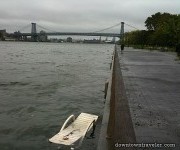
There could be a lot more than lawn chairs out of place after the next big storm.Photo: Downtown Traveler
Cross-posted from Climate Central.
New York City dodged a bullet with Irene, but big trouble passed more closely than most people think. If the storm surge had pushed New York Harbor about one inch higher, it could have been enough to overcome some of Lower Manhattan’s outer defenses and flood the subway system, FDR Drive, PATH, and the Brooklyn-Battery Tunnel, if history is a guide.
At 8:42 a.m. on Sunday morning, close to the peak of an unusually tall high tide, the water reached 4.8 feet above the average high tide level, as measured by a gauge at the Battery. It was the sixth-highest level ever recorded for New York Harbor. The tallest mark came in 1821, at 6.5 feet. The most recent incident topping Irene was the December Nor’easter of 1992, which reached about one inch higher at the Battery and caused enough area flooding to shut down the entire subway system and PATH for several days. Unless the city has substantially raised its defenses, 4.8 feet put Irene in risky territory.
Lots of things could have tipped the balance this time, but didn’t. If Irene had moved more quickly, or blown more fiercely; if it had arrived about 12 hours earlier, during a slightly higher tide. But perhaps the most important element shaping Irene’s outcome was the year it blew in.
For more than a century, sea level has been creeping up, about 16 inches since the Civil War and still rising. If the great hurricane of 1821 had taken place today, it would have reached about eight feet above the high tide line, obliterating all records and a lot of infrastructure.
If Irene were to repeat in 2021 instead of 2011, we could very likely be writing a different story — because in 2021 the average sea level in New York Harbor will be an inch or so higher than it is today, assuming trends continue.
So why is sea level rising? Mostly because of global warming, which is heating and expanding ocean water, and collapsing glaciers and ice sheets. In New York, the land is also slowly sinking, a few inches per century.
Rising seas are a process well under way, not mere speculation. The New York State Sea Level Rise Task Force recently presented the legislature with metro area sea level rise projections of seven to 29 inches by mid-century, and 12 to 55 inches by the 2080s. The range of possibilities is largely due to uncertainty around how rapidly the great polar ice sheets will decay.
Sea level rise will amplify the impact of future hurricanes and Nor’easters. If we replay the 20th century, but add an extra foot of sea level at the start (the extra foot we indeed started with in 2000, compared to 1900), about six events would produce higher water levels than the Nor’easter of 1992.
But this is a very conservative estimate, because it assumes that sea level will rise this century at the same pace it did last century — when in fact we expect much more. If we crudely replay the 20th century, but add an extra two feet of water at the start — overestimating floods early on but underestimating them later — we would see about 30 critical events.
This is how coastal places everywhere will experience sea level rise: previously rare floods will become common — soon — and the new rare floods will be outside of anyone’s experience. It won’t be a matter of just waking up one day to find the high tide at your doorstep.
New York City workers piled sandbags on and around subway grates and other vulnerable areas. If Irene had crept much higher, these measures might not have prevented major damage.
The big lessons from Irene: Invest in more significant defenses, and get a handle on climate change. If not, we will be measuring our future woes in feet, not inches.


