
Cross-posted from Wonk Room.
With the headline “All Florida Waters Open to Fishing,” the Florida Fish and Wildlife Commission claims the “state’s recreational and commercial fisheries have not been affected by the oil spill.” But a Wonk Room analysis finds that oil has spread into areas of the Gulf of Mexico off the Florida coast that are still open to commercial and recreational fishing. An image of the Gulf taken early this morning by the European Envisat radar satellite and processed by the Center for Southeastern Tropical Advanced Remote Sensing at the University of Miami shows the main body of the BP slick extending for hundreds of miles south from the mouth of Mobile Bay. Nearly all of the visible slick is within the boundaries of fisheries closure established by the National Oceanic and Atmospheric Administration (NOAA).
However, part of a slick 20 miles long and five miles wide is in open state waters less than seven miles off the barrier islands of Pensacola Bay, and a 25 mile ribbon of oil is in the open federal waters south of Destin, Fla.:
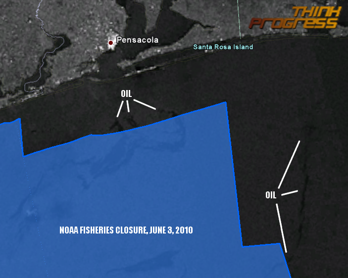 Map created by the Center for American Progress Action Fund from Google Earth, NOAA’s June 3, 2010 fisheries closure map and Envisat’s June 3, 2010 radar image of the Gulf of Mexico processed by the University of Miami’s CSTARS group.
Communicating by email, remote sensing scientist John Amos, the president of environmental imaging non-profit SkyTruth, confirmed the Wonk Room’s analysis that there are oil slicks and sheens outside the boundaries of the fisheries closure after reviewing the satellite imagery.
With the headline “All Florida Waters Open to Fishing,” the Florida Fish and Wildlife Commission dangerously claims the “state’s recreational and commercial fisheries have not been affected by the oil spill”:
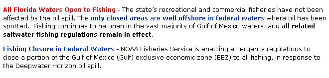
As millions of gallons of oil and over a million gallons of toxic dispersants have spewed into the ocean since the explosion of BP’s exploratory rig 45 days ago, NOAA has expanded the area closed to fishing to a present-day 37 percent of the Gulf, and some state waters in Louisiana, Mississippi, and Alabama have been closed. A federal fisheries disaster declared earlier for Louisiana, Mississippi and Alabama has been expanded to Florida.
However, NOAA administrator Jane Lubchenco, National Incident Commander Thad Allen, and BP CEO Tony Hayward continue to express doubts that plumes of oil and dispersants are invisibly contaminating the Gulf.
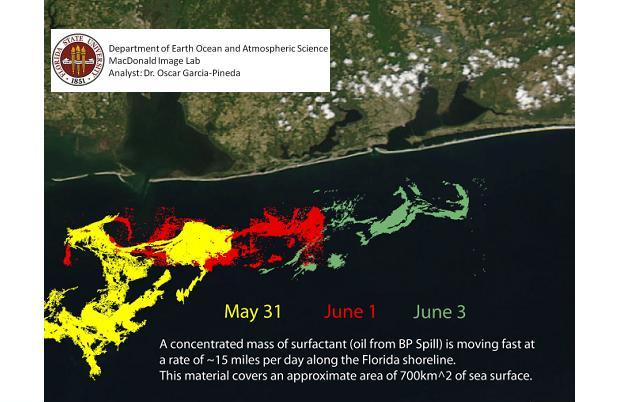
UPDATE: Dr. Oscar Garcia-Pineda and Dr. Ian MacDonald of Florida State University have given the Wonk Room their exclusive analysis of the oil slick that has moved into Florida’s open fishing waters:

