Observant people who’ve driven through Canada their entire lives may have noticed a shift in their natural surroundings. That is, they’re greener: A huge portion of the country, roughly equal to the area of the entire United States, is sprouting thick, luscious new coats of trees and bushland.
Scientists monitoring the Northern American landmass from space have seen it happen over the past three decades, and now they’ve released data fingering climate change for the unusual boom in vegetation. Writing in Nature Climate Change, researchers with the NASA-funded study say that winters above the U.S.-Canada border are warming up quicker than the summers. That’s causing the seasons to blend together, thawing out the ground for longer periods of time and supporting an eruption of “vigorously productive vegetation” covering about 3.5 million square miles.
This burgeoning green bandana wrapped around America’s forehead is making the landscape surrounding Canadian cities look more like that of their American brethren. Here’s how one of the researchers describes it:
The temperature and vegetation at northern latitudes increasingly resemble those found several degrees of latitude farther south as recently as 30 years ago. …
“Arctic plant growth during the early 1980s reference period equaled that of lands north of 64 degrees north. Today, just 30 years later, it equals that of lands above 57 degrees north — a reduction in vegetation seasonality of about seven degrees south in latitude,” says co-author Prof. Terry Chapin, Professor Emeritus, University of Alaska, Fairbanks. The change equates to a distance of approximately 480 miles southward.
How’s that? Over at NASA’s Goddard Space Flight Center in Maryland, Compton Tucker, who participated in the study, says that it’s “like Winnipeg, Manitoba, moving to Minneapolis-Saint Paul in only 30 years.”
The flight center’s computer-visualization gurus have put together this neat map of the growth explosion, which has infested 34 to 41 percent of the north’s vegetated lands. Green and blue areas represent new plant life, orange and red show decreases in vegetation, and yellow means there’s been no measurable change in the past three decades:
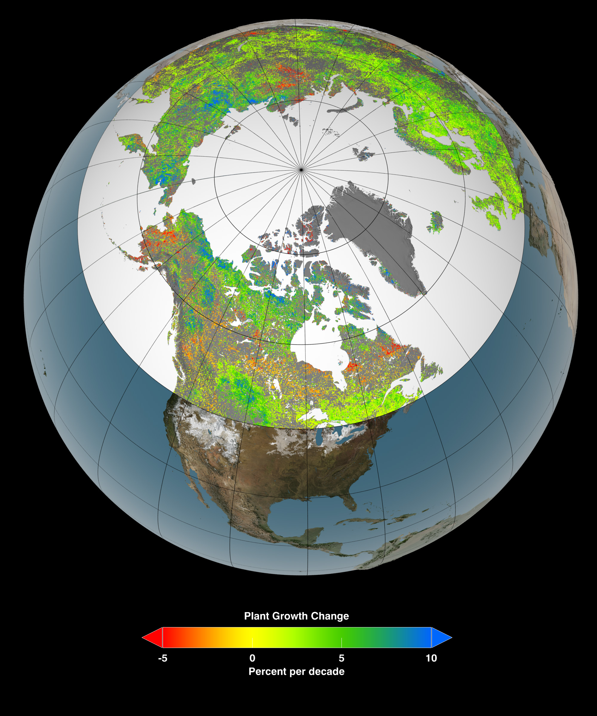
NASAClick to embiggen.
So is now the time for Canadian loggers to throw their chainsaws in the air with glee? Not really. There are still plenty of variables that could hobble or shift the vegetation eruption over coming decades. These are highly dependent on how climate change could disrupt ecosystems: Harsher droughts during the summer could take their toll on tree health, for instance, as could more frequent and widespread wildfires. There’s also the possibility of ramped-up infestations by plant-killing pests and fungi, which are likely to love a warmer, greenhouse-gas flooded climate.
This story was produced by Atlantic Cities as part of the Climate Desk collaboration.