During the most heated point in the debate over the Keystone XL pipeline last year, the state of Nebraska was poised to act as spoiler. The pipeline as initially proposed ran over Nebraska farmland, but also — critically for the region — over the Ogallala Aquifer, a pristine water source widely tapped for drinking and irrigation.
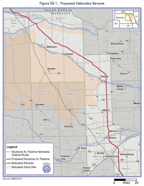
Given the significant possible damage to the aquifer from a spill, TransCanada, the Canadian company that hopes to build the pipeline, proposed an alternate route. That new route avoids the Nebraska Sand Hills, a region that acts as a sort of sponge for the aquifer. Mother Nature Network describes it:
[The Sand Hills] may not be as well-known as the Mississippi Delta, the Everglades or the Chesapeake Bay, but they harbor one of the most pristine wetland ecosystems in the entire Lower 48 states. Not only is the area home to swaths of unspoiled prairie and wetlands — which themselves are home to a diverse menagerie of wildlife — but it also serves as a capstone for the Ogallala Aquifer, a giant underground freshwater source that provides nearly one-third of the country’s irrigation groundwater. …
As much as half of the region’s annual rainfall percolates down to the Ogallala Aquifer, which contains an estimated 1 billion acre-feet of groundwater below the Sand Hills.
An uncontrolled spill of thick, corrosive tar-sands oil would be a massive disaster. Here’s the new route proposed by TransCanada, threading the needle on the Sand Hills.

NDEQClick to embiggen.
Nebraska has now completed its assessment of that new route. From the state’s Department of Environmental Quality:
- The Nebraska Reroute avoids the region that was identified as the Sand Hills by NDEQ, which is based on extensive research conducted by various state and federal agencies several years ago.
- [TransCanada Keystone Pipeline (Keystone)] provided some route alternatives in the Supplemental Environmental Report which reduces the amount of fragile soils that are crossed in the northern portion of Nebraska.
- The revised route also establishes greater distances from the sources of drinking water in the communities of Clarks and Western. …
- Numerous construction and operational mitigation measures would be incorporated to protect groundwater and surface water.
- Keystone would pay for an independent public employee to act as a liaison to facilitate the exchange of information between Keystone and landowners, local communities, and residents.
- Keystone would provide baseline water well testing for domestic and livestock water wells within 300 feet of the center line of the route.
The report says Keystone XL would create 110 full-time-equivalent jobs during construction, and support 2,740 new or (allowing some flexibility) existing jobs after the pipeline is complete.
Which all sounds good. Except that this report only addresses one aspect of a very complex situation. Even a spill that didn’t permanently pollute a critical source of drinking water could be disastrous. And TransCanada’s existing pipelines are not without problems.
Not to worry. The report notes that Keystone has committed to carrying at least $200 million in third-party liability insurance to cover “sudden and accidental pollution incidents from Keystone XL Pipeline in Nebraska.” A little cash will make all that oil go away. Though Nebraska would be wise to be skeptical of TransCanada’s promises to pay money it owes.
It’s worth noting that this doesn’t mean Keystone XL will get built; it just means TransCanada has made progress in blunting the Nebraska government’s opposition to its plans. For construction to begin, TransCanada will need the president to sign off on a federal permit. So for that, the company has to wait until after Election Day.


