This story was originally published by Yale Environment 360 and is reproduced here as part of the Climate Desk collaboration.
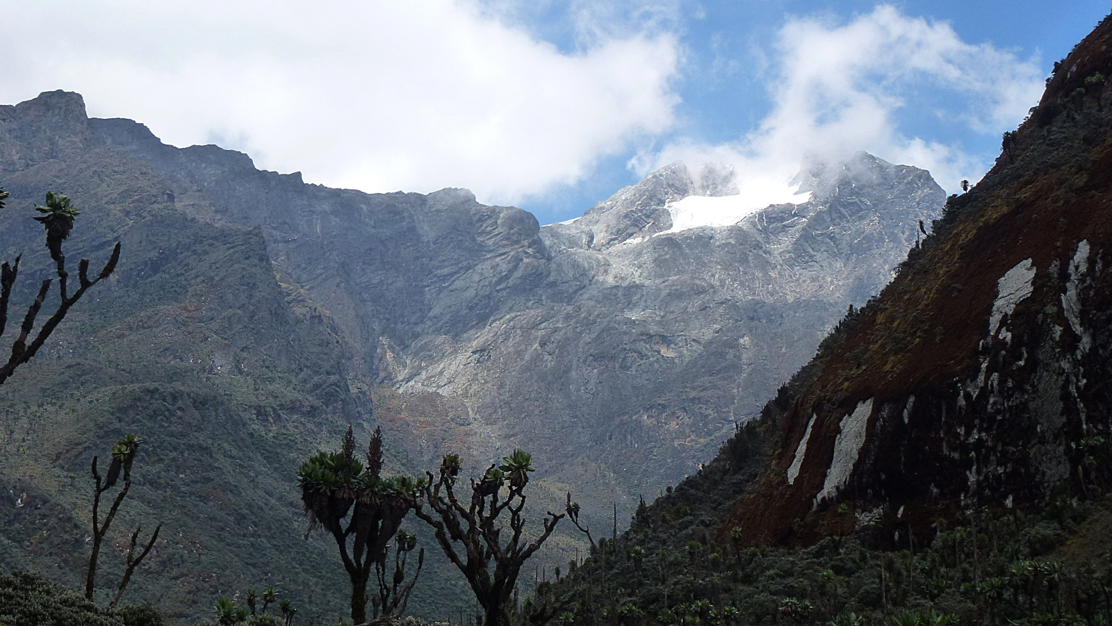
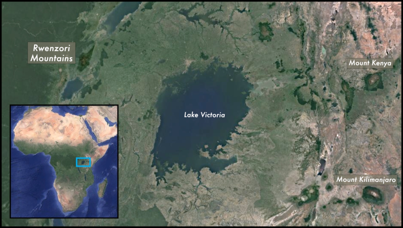
Enock Bwambale stopped at the lip of the dying glacier, its blunted nose arcing steeply down to scoured rocks, then shouted up to his fellow guide Uziah Kule that the ice was too sheer to descend on foot. Hacking his axe into the crusty surface, he twisted in an ice screw so I could rappel down the stubby face of the Stanley Glacier in Uganda’s Rwenzori Mountains National Park, a UNESCO World Heritage Site on the border with the Democratic Republic of the Congo.
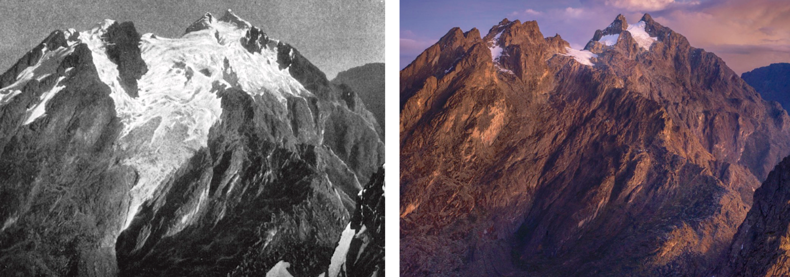
Safely down, our small group took in the view of the heights of Mount Stanley: Margherita Peak — at over 16,700 feet (5,100 meters), the third highest point in Africa — and Alexandra Peak, between which hides the Stanley Glacier. I swung my camera around and tried to match a photo by Vittorio Sella, who had documented the summits of the surreal Mountains of the Moon during the first successful European summit attempt, in 1906. But an equivalent contemporary shot was impossible: Sella had taken his photograph from atop a healthy glacier that had been hundreds of feet higher than my head.
“Up there nowadays, there’s no glacier,” said Kule. “The glacier we only get it in the valley here.”
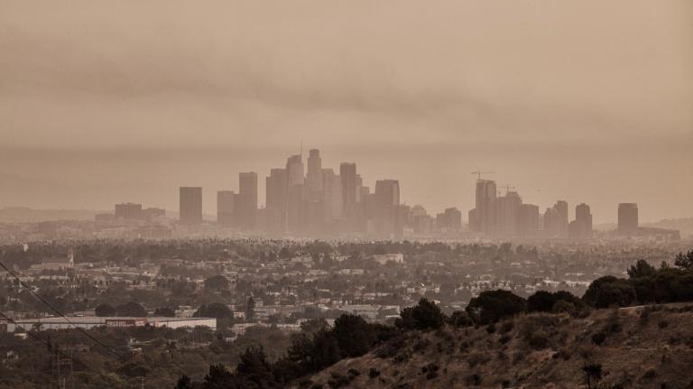
Worldwide, climate change is causing glaciers to retreat. But African glaciers, which all lie within a day’s drive of the equator, are melting faster than the global average. Since 1906, more than 80 percent of the Rwenzoris’ ice has melted, and UNESCO recently reported that a third of the 50 World Heritage sites that contain glaciers, including the Rwenzoris, will disappear by 2050 no matter what actions are taken to slow global warming. Some scientists predict that Uganda’s glaciers could be gone even sooner: within a decade.
Scientists say the loss will herald dramatic changes for this unique ecosystem, a sky island surrounded by a sweltering sea of lowland forest. Little-studied endemic species could go extinct as temperatures rise; vulnerable local communities anticipate the loss of previously reliable tourist revenue; and scientists will lose historical climate data as the ice that indicates temperature changes over centuries turns to water.
“The loss of these glaciers is the loss of a critical component of a system, and it isn’t going to come back any time in the foreseeable future,” said James Russell, who has led expeditions to the Rwenzoris almost every year since 2006 and chairs the department of earth, environmental, and planetary sciences at Brown University. “It’s heartbreaking.”
Setting out at 2 that morning, we had crossed two glaciers in the dark and summited Margherita Peak just before sunrise. It had taken us six days to get to this point — sometimes hiking rainforest trails so steep that our guides had installed bamboo ladders. Other times we slogged through knee-deep mud.
But even on day one, the impact of climate change was evident in the village of Kilembe, our starting point. Here, houses stood tottering on the edge of the riverbank, cracked open to the sky since powerful rains, which started a decade ago, had repeatedly caused flash floods, killing dozens and displacing thousands.
Leaving the cultivated hillsides of the village, we crossed the park border and soon entered tropical forest, where jewel-like flowers peered out from under giant ferns, and monkeys materialized and vanished as mist sieved through buttressed hardwoods. We trekked through bamboo forest, climbing to 12,800 feet (3,900 meters), where we entered the otherworldly Afro-Alpine moorlands, which contains endemic, endangered, and rare species.
For two days we leapt from grassy tussocks to slippery tree roots, through bogs of spongy moss and silent rivulets. Beards of lichen waved from the branches of giant heather trees. Rwenzori red duikers, an endangered subspecies of antelope, stared from dense thickets of papery silver everlastings.
The plants, uniquely adapted to their habitat, got weirder as we climbed. Giant groundsels dotted the valley floors. Their spiky green pompoms make them look like palm trees, but their shaggy coats of dead leaves protected them from the cold.
As the planet warms, plants and animals are moving upslope in the Rwenzoris, as they are elsewhere, seeking cooler temperatures. But there’s only so far they can go. Eventually, “they will just step their way off the top of the mountain,” said Sarah Ivory, a researcher at Penn State.
“You find rock hyrax footprints on the glaciers now,” Bwambale said as we hiked. “The same for the duikers.”
On the fifth day, we noted some changes of our own. Holding up one of Sella’s photos to compare it to today’s landscape, we discovered that a glacier-fed pond nestled in the valley between Mount Baker and Mount Stanley had shrunk to almost nothing.
The three highest points in Africa have all lost dramatic amounts of ice in the last century, reports a 2019 paper published in Geosciences. On Tanzania’s Mount Kilimanjaro, the highest point in Africa, the ice has shrunk by 90 percent since its first survey in 1912, to less than 1 square mile. The glaciers on Mount Kenya, Africa’s second highest peak, are less than a tenth of a square mile. Glaciers in the far less studied Rwenzoris covered an estimated 2.5 square miles in 1906; in 2003, they covered less than 1 square mile. Today, they are even smaller.
While glaciers are retreating everywhere, the causes are different from place to place. In the Rwenzoris, where glaciers occur at a relatively low 14,400 feet (4,400 meters), warming air is the problem. The mountains, whose name means “rain maker” in the local language, receive 6 to 10 feet of precipitation a year, so the glaciers are not being starved of water — they are just melting faster than rain can freeze and replace the melted ice. However, on Mount Kilimanjaro and Mount Kenya, where the ice occurs at higher elevations, precipitation has declined. Here the ice is evaporating into the dry air.
Whatever the cause, high-elevation ice is disappearing all over — a trend that will continue as global warming accelerates the rate of change in mountain ecosystems, cryospheric systems, hydrological regimes, and biodiversity, according to the Mountain Research Initiative.
Ice is also melting rapidly in South America’s Andes, where tropical glaciers also occur. As in Africa, these glaciers form because of altitude, not latitude, and they are unaffected by seasons or strong changes in weather. The main difference between the two regions is how melting will affect humans: the retreat of large ice caps and glaciers in South America threatens supplies of irrigation and drinking water, but Uganda’s glaciers are so small that no communities depend on their meltwater.
As everywhere though, the rapidly disappearing ice on Africa’s mountains poses an urgent problem for climate scientists. On Mount Kilimanjaro, around 2,000 years of the most recent climate data has disappeared as the surfaces of ice fields have evaporated, according to a 2002 paper in Science. The loss of information derived from ice cores (which contain pockets of ancient air) makes it hard for climate scientists to make accurate models for tropical Africa or to provide that information for global models. Compounding the problem, tropical zones tend to lack recent written records of weather, and constant cloudiness over the Rwenzoris limits satellite measurements.
Because of these knowledge gaps, said Russell, of Brown University, “we have very little idea about what the equatorial tropics did through time.”
To get around this, Russell and other researchers have relied on other methods, extracting alpine lake sediment cores, which, like ice cores, can go back tens of thousands of years; analyzing isotopes found on flakes of stone, which indicate when they were exposed to the sun after ice retreated; and feeding laboriously gathered glacial moraine data into computer models that calculated the extent of past ice maximums. Without understanding what happened to ice in the past, researchers cannot understand what is happening in the Rwenzoris today.
Over the past few years, this intensive study has revealed that ice-free conditions could occur in the near future in the Rwenzoris. And while the exact drivers of glacial loss are still debated, what is certain is that the livelihoods of those who depend on them are under threat. In the village where my guides live, the melting of Rwenzori glaciers presents a major blow, since tourism employs around 650 people there.
“When [the glaciers] disappear completely, it’s going to be tough,” said Bwambale, as he stood below peaks that were once so white that locals thought they were made of salt. “For the younger generation, they will never see the real beauty of the mountain.”
We rose at 2 a.m. on day six and pulled on the cold weather gear jammed into the bottoms of our bags — needed only for the summit. Hiking on barely visible trails and sliding down scree chutes, we traversed a landscape of broken rock freshly deposited by retreating glaciers. As I puffed along, Kule lamented how the retreating and thinning ice has forced the guides to find new and sometimes much tougher routes to the summit.
Having already crossed the lower Elena Glacier, we hiked, climbed, and slid until we reached the bottom of the Stanley Glacier, at around 14,700 feet (4,500 meters). It was still dark. Our guides helped me strap on my crampons, and we started the easy but tiring final ascent.
In 1906, the explorers crossed a gently sloping ice plain. Today, the glacier is a steeply pitched mass of ice hugging the contour of the valley between Alexandra Peak and Margherita Peak, our goal. To reach the very top, Edwardian explorers had to stand on each other’s heads in hobnailed boots to pull themselves over a giant cornice formed by the rapid daily melting and freezing of ice.
At the top, the 1906 team found that all was “covered in snow, and not a single rock comes to the surface.” Indeed, there was so much snow that they suffered intense snow blindness for days. When we summited at around 7 a.m., we saw not a scrap of snow. Instead, we walked along an icy, rock-strewn trail and took in a stunning sunrise that painted the patches of snow on Alexandra Peak in peach and gold.
We lingered to look at the Stanley Glacier, lying below us, aware that this rump of ice surreally situated just a few dozen miles from the equator will most likely cease to exist very soon. I snapped a few pictures, and then we headed down.
Because the Rwenzoris are visited relatively rarely, the scientists I interviewed after I got home often asked to see my photographs. They all wanted to see how much the ice had retreated. Leaning over a shared Zoom screen, Georg Kaser slid his spectacles down his nose like a medical doctor looking for the symptoms of a terminal illness and examined my photos of the Stanley Glacier and the newly exposed walls of rock on either side.
Lead author of two chapters of IPCC reports, Kaser summited Margherita Peak in 1991 and is the former dean of the Institute of Atmospheric and Cryospheric Sciences at the University of Innsbruck. Studying the orange, black, and brown rocks, he pointed at a cliff featuring a line of discoloration. This “indicates a rather recent retreat,” said Kaser.
Combining his evaluation of the photos with knowledge of the modern climate conditions brought Kaser to a stark prognosis for the Rwenzoris, and all of Africa’s glaciers. “You can negotiate about almost everything,” he said, “but you cannot negotiate the melting point of ice.”