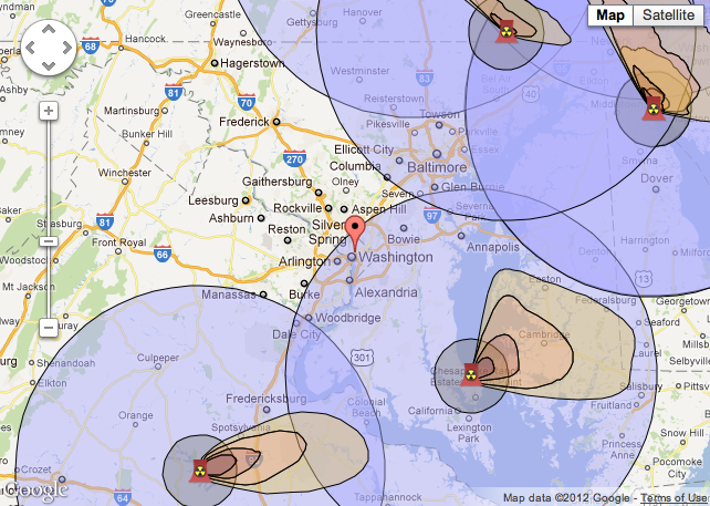

With the one-year anniversary of the Fukushima reactor crisis approaching, the Natural Resources Defense Council has put together a mapping tool that lets you envision what could have happened if one of the 104 U.S. reactors had suffered a similar accident. The take-home message: If you live on the East Coast, you’re practically guaranteed to be in some power plant’s 50-mile contamination zone.
Of course, because it shows the location and fallout area of every plant, the map looks more like “what would happen if every nuclear facility in the U.S. melted down at once.” That’s unlikely, and therefore a little misleading. A situation like Fukushima is rare and requires a confluence of failures, and the seriousness depends on factors like reactor type and age — so you’re very unlikely to see a situation like the map above, where every power plant near D.C. suddenly wets the bed at once.
In 2011 five nuclear plants had emergency shutdowns — but unlike Fukushima, they didn’t lose backup power so none of them suffered an accident. Here’s NRDC’s list of the shutdowns, in case you want to map them:
- Calvert Cliffs – Lusby, Md. (due to hurricane)
- North Anna – Louisa, Va. (due to earthquake)
- Ft Calhoun – Ft Calhoun, Neb. (due to flooding)
- Browns Ferry – Athens, Ala. (due to tornado)
- Surry – Surry, Va. (due to tornado)
A message from
Your support keeps our climate news free.
Grist is the only award-winning newsroom focused on exploring equitable solutions to climate change. It’s vital reporting made entirely possible by loyal readers like you.
At Grist, we don’t believe in paywalls. Instead, we rely on our readers to pitch in what they can so that we can continue bringing you our solution-based climate news. Donate today to keep our site free.