Lisa Hymas has a good overview of the 1,924 new high-temperature records set across the United States last week. The only numbers in that post that aren’t three digits are the ones indicating the timescale of the upcoming problem: within 60 years, it will be ubiquitous.
Here’s what these hotter temperatures and shifts in weather systems look like to the people experiencing them:

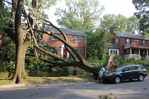
A tree down in Washington, D.C. (Photo by woodleywonderworks.)
Temperatures in Hill City, Kan., hit all-time highs at the end of June. From a report by The New York Times:
For five days last week, a brutal heat wave here crested at 115 degrees. Crops wilted. Streets emptied. Farmers fainted in the fields. Air-conditioners gave up. Children even temporarily abandoned the municipal swimming pool. Hill City was, for a spell, in the ranks of the hottest spots in the country.
“Hell, it’s the hottest place on earth,” [said] Allen Trexler, an 81-year-old farmer who introduced himself as Old Man Trexler. He spoke while standing in the shade of a tree on Saturday morning, the temperature already sneaking toward 100.
The heat wave extended east. On Sunday, Atlanta tied its all-time high temperature of 106 degrees — a record set the day prior.
In parts of Georgia and Tennessee, the air quality was so bad over the weekend that officials scrapped their Code Red warnings and dubbed the steamy haze a Code Purple, signaling very unhealthy air.
In North Carolina, the heat had a different impact.
Heat records are being shattered all over the country and it was so blazing in North Carolina that a highway buckled and had to close. …
Authorities say it got so hot the pavement buckled on Interstate 440, closing the southbound lanes near the Interstate 40 west exit.
A derecho — a windstorm accompanied by a line of thunderstorms — whipped from Illinois eastward to the Atlantic coast, bringing enormous damage to West Virginia, Virginia, and Washington, D.C. See the path it traveled:
Its impact was particularly damaging in West Virginia.
“We have outages in 53 of the state’s 55 counties,” said State Homeland Security Secretary Jimmy Gianto. “Some of those are 100-percent without electricity.” …
The damage stretches from the Ohio River to the Shenandoah. A caller to West Virginia Outdoors eating dinner at the Huntington Prime restaurant Friday night said he and his wife saw the storm coming.
“We felt the building tremble a little bit and all of a sudden five big window panes busted out in the restaurant,” he said.
Another caller was working on his car in the driveway and headed for the house as the wind picked up.
“As I was stepping in the front door it actually ripped the roof off the porch and flipped it up on the roof,” he said.
Driving through the state afterward struck one man as “post-apocalyptic.”
Harrowing drive today from Ohio to North Carolina. West Virginia under a state of emergency, no gasoline available in the entire state.
— Mark Sample (@samplereality) June 30, 2012
Never saw so many abandoned cars on the side of the road outside a blizzard.
— Mark Sample (@samplereality) June 30, 2012
It was a post-apocalyptic 500 mile drive for me and my two boys today, but I’m thankful for the power and AC at home.
— Mark Sample (@samplereality) July 1, 2012
Even those far from the storm felt its impact as an Amazon server system outage brought down Instagram, Netflix, and other popular websites. As the weather becomes increasingly turbulent, impacts on infrastructure (digital and not) will increase.
And the weather will become more volatile. Scientists and forecasters are increasingly willing to attribute these weather events to climate change, and offer unhappy predictions for what’s to come:
Climate change is already affecting extreme weather. The National Academy of Sciences reports that the hottest days are now hotter. And the fingerprint of global warming behind this change has been firmly identified.
Since 1950 the number of heat waves worldwide has increased, and heat waves have become longer. The hottest days and nights have become hotter and more frequent. In the past several years, the global area hit by extremely unusual hot summertime temperatures has increased 50-fold. Over the contiguous United States, new record high temperatures over the past decade have consistently outnumbered new record lows by a ratio of 2:1. In 2012, the ratio for the year through June 18 stands at more than 9:1. Though this ratio is not expected to remain at that level for the rest of the year, it illustrates how unusual 2012 has been, and how these types of extremes are becoming more likely.
In a decade, we could very well look back at this article as the good old days.
Update: NPR has a good look at how the aftermath of the storm is impacting West Virginia.


