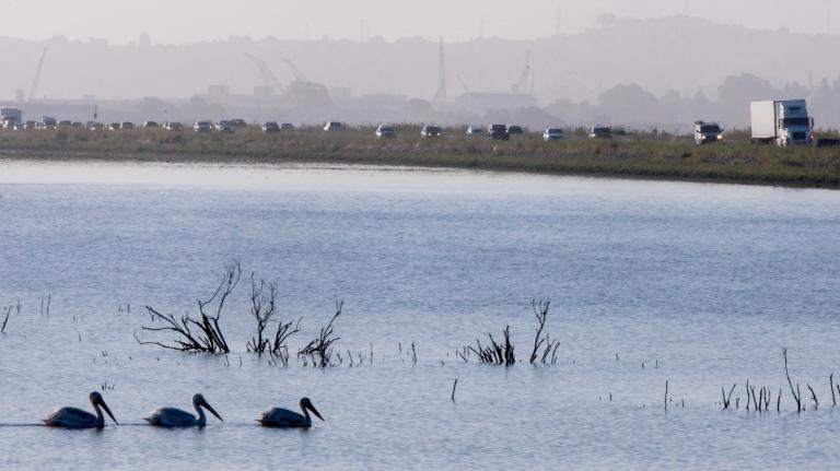
Norfolk, Va., offers a hint of what’s to come for many coastal communities as climate change pushes tides higher and storms continue to worsen. Norfolk sits at the southeast corner of Virginia, where the Atlantic Ocean meets the Chesapeake Bay. Surrounded by water on three sides, the city of 243,000 will experience more sea-level rise than other locales, scientists say. Some areas of the picturesque old city — home to a major Navy base and full of old houses and cobblestone streets — already flood regularly.
Agencies, residents, and businesses, have already banded together to weather the rising waters, says Norfolk’s manager of Environmental Protection Programs, Denise Thompson. “We all speak the same language,” she says. “Everyone tends to help each other out. People might say to their new neighbors ‘You need to move your car up the street’ or ‘The city’s getting ready to open up the garages. You’ll be able to move your car there for free so that you won’t have to worry about flooding your vehicle.’”
Thompson, an environmental health scientist by training, has been looking at the way humans and the environment interact since the 1970s. The issue first piqued her interest in high school, when her debate team was discussing whether the federal government should regulate pollution. In her research, she came across DDT and pesticides and closed beaches. “The light bulb went off for me,” she says.
Thompson says there were times in the 1980s when she wondered “if the environment was a good place for a career,” but today, “sustainability really has become the lens in which businesses and governments are starting to view the world.”
Norfolk, for its part, opened Virginia’s first light rail system (called The Tide) a little over a year ago, and daily ridership is already up to 5,000. And the Navy has turned out to be a swell partner in going green — it just launched Virginia’s largest solar farm and the base has a green roof and LEED-certified aircraft hangars.
Of course, it all comes too late to stop the waters from rising — even with drastic cuts to our emissions (cuts that seem improbable, even impossible) sea level will continue to rise for the foreseeable future. What is Norfolk doing about that? I talked to Thompson for Knope and change, our series on the woman working to green city governments. Here’s our edited conversation about coping with the current and coming floods, cleaning up the Chesapeake Bay, and why she feels optimistic about nature’s ability to recover from all the damage we’ve wrought.
Q. Are you ever disheartened that we moved forward on so many issues yet now are stuck again? It seems like the climate movement is going through many of the same motions that you saw in the ’70s.
A. I’m heartened that everyone is talking to each other and working on it. We have a bit of a different perspective in Norfolk. We’ve had a long history of flooding and we’ve had major floods. In 1933, we flooded during the hurricane and in 1960, there was the Ash Wednesday storm. In the late 1960s, the Army Corps of Engineers built a downtown flood wall and flood gates and pump stations to protect the downtown. The idea that we’ve got rainwater and seawater to deal with — that’s not new to us. But I’ll tell you what is new to us: Four of the seven most significant tidal events in the past 80 years happened in the last 10 years. Put another way, more than half of the major tidal events since 1933 all occurred since 2003. [A NOAA tide gage shows] the relative means sea level at Sewells Point has risen 14.5 inches. [About half the rise was caused by land sinkage. NYT breaks down the numbers.] That’s a lot of water.
Q. How are you planning for more flooding and sea-level rise?
A. We realized we could fit everything we’re doing into four parts: plan, prepare, mitigate, and communicate. As it turns out, they’re all just about as important. The planning part includes civil engineering and structural approaches. Floodwalls, installing pumping equipment. We have elevated roads and likely will do more of that. We’re working with a Netherlands company called FURGO Atlantic as well as local engineers to plan. The other part I’m really excited about, having started life as a biologist, is we’re looking at the blue-green infrastructure of trees and rain gardens and even our parks and wetlands. We’re doing a lot of wetlands restoration because those are really the buffers that protect the coastline. It’s pretty exciting because there are so many benefits [to soft infrastructure] — aesthetic, habitat, water quality, livability benefits.
We’re looking at what do we do about development and redevelopment. Does it make sense to build what we’ve been building in areas that flood? The obvious and well-research answer is “No.” And so we’re making changes to our long-range plan as well as to our zoning regulations. In terms of rebuilding or adding on, the elevations of the finished homes need to be higher. Otherwise, you’re building a problem for yourself.
The communicate piece has turned out to be hugely important. Very early on, we set up two committees. One is a citizen and residents committee. The other is an experts advisory committee [with representatives from NOAA, NASA, the Army Corps of Engineers, the Navy, etc.]. Those groups meet regularly and it’s provided a way for us to get out the science, the studies, and the information we have out into the community.
Q. How much sea-level rise are you looking at? How far out are you planning?
A. The numbers we are hearing at this point are two to four inches [of sea-level rise] every decade. Generally our long-term planning is 30 years but some infrastructure lasts longer than that. If it’s something that potentially would last longer than that, we’re look beyond that. Most people tend to be looking at 30-50 years out. But they’re not neglecting the 100 years out either because, especially for us, we can walk around and see buildings that were here 100 years ago. It’s not unimaginable that people will be here in 100 years looking at the buildings we built now as well as the ones from 100 years ago.
Q. The Chesapeake Bay has been greatly affected by agricultural runoff and other pollutants. In 2010, it contained the nation’s third-largest dead zone. In 2011, one-third of the bay was a dead zone. What is Norfolk doing to improve the health of the bay?
A. The interesting thing about the bay, you’ve got the 200-mile-long estuary that goes from Maryland to Norfolk. The bay also includes 50 major rivers and streams that go across land, whether it’s farmland or city, and into the bay. We’re looking at the 100-percent solution. Half of [the pollution] is “point-source” which is the wastewater system and wastewater treatment plants. The other half is runoff and “non-point-source,” [the runoff from streets and parks and yards]. We have a couple ways we’re approaching that. One is from the city side — we’re building more swales and more rain gardens and catchment basins. We have a very aggressive street sweeping program. We sweep every street in the city at least once a month. There’s a voluntary program called River Star for homes and businesses. Runoff is a real lot-by-lot, house-by-house, block-by-block approach you need to take.
Q. That’s all very cool, but in the face of factory-style farming growing in the region … can it make enough of a difference? It seems like in recent years, the bay has been getting worse, not better.
A. The last Bay Foundation report showed the bay to be holding its own and becoming a little bit better. … You are absolutely right that you have to look at the whole watershed of 17 million people. We’re 50 square miles maybe, counting water. We have 140 miles of shoreline so of course we care deeply about our water and our shorelines and the water quality of the bay. In Norfolk, we don’t have poultry farms, although we do allow backyard chickens and beekeeping.
If you look at it big picture, possibly the agriculture folks could do more. If you look at the Elizabeth River, at one point, it was very difficult to find any kind of aquatic life. [A 2008] report showed 38 percent of small fish called mummichogs had cancerous lesions. When the Elizabeth River Project started restoration efforts [in 1993], some people thought it couldn’t be done. The Elizabeth River Project says there are now dozens of species of fish, small crabs, shrimp. Of course, there’s still lots to do but that water body is coming back. They even found a little sea horse. The day they found it was very exciting. It was in an area that was considered to be a biological dead zone.
There are so many things that are positive so if you get frustrated, you don’t stay frustrated very long. It turns out nature does respond to restoration efforts.