Or, illustrated another way, here’s the percent of land area that saw “very warm” or “very cold” temperatures over the last several years.
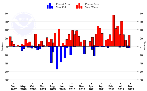
If that’s too hard to read, here’s how it breaks down: Over the 12 months of 2012, 34.3 percent of the country was unusually warm, on average. Only 0.7 percent was unusually cold.
Which exacerbated and contributed to the — still ongoing — drought. From Weather Underground:
According to NOAA’s monthly State of the Drought report, the 61.8% of the U.S. covered by drought this week was also what we had during July, making the 2012 drought the greatest U.S. drought since the Dust Bowl year of 1939. (During December of 1939, 62.1% of the U.S. was in drought; the only year with more of the U.S. in drought was 1934.) The Great Drought of 2012 is about to become the Great Drought of 2012- 2013, judging by the latest 15-day precipitation forecast from the GFS model.
Consider that. The level of drought in the U.S. right now is equivalent to what we saw in July.
The temperature extremes also continue. Des Moines hasn’t seen a subzero day in almost two years. Washington, D.C., saw its warmest year in history, with December temperatures running 5.6 degrees F above the 1980-2010 normal and a forecast of above-average temperatures to come.
So far this year, NOAA hasn’t recorded any record temperatures at its observation stations. But then: the year is young.