
[sigh] Hello.
I know you’re tired of hearing about Hurricane Sandy. Or maybe you’re not. Who knows. If you are, I’m sorry. I can’t help it. I live on the East Coast. This, this thing is bearing down on me. I bet it was just as hard for Damocles not to always be blogging about swords. And since I made the first Sandy-related GIF several days ago, by the laws of the internet, I own the story.
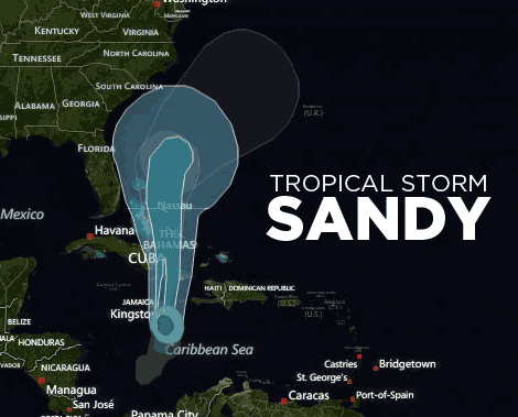
Here’s where we are this morning.

As you can see, the anticipated track continues to shift west and south. The storm should make landfall Monday night, probably somewhere near Delaware. But as it has over the past few days, that track could change.
Again, this isn’t just a hurricane. It’s a hurricane that’s going to combine with a nor’easter. From Bloomberg:
Sandy’s apparent weakening doesn’t accurately predict the storm it may become, said Matt Rogers, president of Commodity Weather Group LLC in Bethesda, Maryland. Computer models suggest the hurricane may transform into a hybrid system over the weekend because of another storm moving in from the Midwest.
“When the storm phases with the energy from the west, it is forecast to deepen rapidly,” Rogers said. “Indeed, it is expected to continue weakening until phasing really takes place late Sunday into early Monday.”
“We can say even now our worst fears may be realized,” [National Weather Service meteorologist Paul Kocin] said. “If we were seeing what we’re seeing today one day out, we would really be shouting the alarms.”
Climate Central explains the mechanics of that combination.
As Sandy moves northward, it will move over cooler water. If this were all that were happening, Sandy would weaken, as tropical cyclones moving toward a pole typically do. At the same time, though, Sandy will come close enough to the upper trough now over the U.S. to interact with that trough in something like the way that an extratropical surface low normally would.
When this happens, they will form a hybrid storm system with some tropical and some extratropical properties. Some energy will still come from the ocean surface, but some will now come from the pole-to-equator temperature contrast. This new energy source will enable Sandy to maintain its intensity, or maybe even increase it.
This process is called “extratropical transition.” It poses a lot of problems for forecasters. In the first place, the computer models aren’t that great at predicting exactly when it will happen. So predictions of intensity are uncertain, as the tropical cyclone may weaken before transition and then strengthen afterwards.
[protected-iframe id=”0c76bafd6139019fa2f2e9c980e074ad-5104299-36375464″ info=”http://project.wnyc.org/hurricane-tracker-sandy/index.html” width=”470″ height=”700″ frameborder=”0″ scrolling=”no”]
The Capital Weather Gang reminds us that the snor’eastercane “may be unprecedented in East Coast storm history.”
Model simulations have consistently simulated minimum pressures below 950 mb, which would be the lowest on record in many areas.
“MODELS SHOW PRESSURE WELL BEYOND WHAT HAS EVER BEEN OBSERVED NEAR THE NJ/NY COAST (EVEN EXCEEDING THE 1938 LONG ISLAND EXPRESS [HURRICANE])”, writes NOAA’s Hydrometeorological Prediction Center (HPC).
Connecticut meteorologist Ryan Hanrahan noted there has only been one tropical storm with the pressure below 960 mb in the last 60 years in the Northeast.
So, resources: What should you read to gauge how panicked you’re supposed to be? Actually, it might be harder NOT to track Sandy’s progress. Media organizations are gearing up to cover this thing top to bottom. Some media organizations will be alarmist. Prepare for that. But check these ones out:
- Reuters already has a live-blog up
- Mother Jones has a good explainer that they’re updating regularly
- The Guardian has a live-blog, as well
- Follow the Capital Weather Gang on Twitter
- There are regular updates at Weather.gov and the NOAA

Weather.govClick to embiggen.
From the end of that Capital Weather Gang post:
A very prominent and respected National Weather Service meteorologist wrote on Facebook last night,
“I’ve never seen anything like this and I’m at a loss for expletives to describe what this storm could do.”
Good luck. And God be with you.
Update: If you think the Weather Service guys are freaking out now, here’s how they reacted to the storm season in 2005.
Update: A good video explanation from the AP.
Update: A satellite view of Sandy, as of 3:30 pm on Friday.
