Memo to anti-science crowd: Precipitation isn’t temperature!

Another massive mid-Atlantic precipitation event, another piece of nonsense from the anti-science crowd. Kevin Mooney of the American Spectator actually wrote an article titled, “Snowmageddon” Versus “Overwhelming Scientific Evidence,” which asserts:
This is the first time since record keeping started that two storms of such magnitude have hit the region during one winter. Already some localities are reporting the largest snowfall ever recorded.
To be sure, these events do not prove or disprove human caused global warming. But the momentum is now very much on the side of skeptical scientists who question these theories and President Obama should at least pull back from his awkward juxtapositions.
Yes, for the anti-science crowd, the kind of extreme precipitation event the mid-Atlantic states just experienced somehow weighs against the overwhelming scientific evidence for human-caused climate change — even though it is entirely consistent with the predictions of climate science (see Was the “Blizzard of 2009″ a “global warming type” of record snowfall — or an opportunity for the media to blow the extreme weather story (again)? and analysis by uber-meteorologist, Dr. Jeff Masters below).
What’s particularly laughable about Mooney’s article is that according to the UAH satellite data so beloved of the anti-science crowd, the storm occurred on the warmest February 6 — and indeed, during the warmest winter — in the temperature record (data here — the orange line ending in the white box in the figure above tracks temperatures in 2010).
Capital Climate has an excellent analysis on Super Storm 2010, which finds:
The conclusion I would draw from all of this is that the 2010 storm was distinct from other similar events in the past by having moisture be the dominant element over temperature in producing the extreme snow amounts.
Hmm. If only there were a theory to explain why we might be seeing massive amounts of moisture and extreme precipitation events….
The rest of this post is “Heavy snowfall in a warming world,” a reprint from the website of one of the best meteorologists around, Dr. Jeff Masters, former Hurricane Hunter and now Director of Meteorology for the Weather Underground:
A major new winter storm is headed east over the U.S. today, and threatens to dump a foot or more of snow on Philadelphia, New York City, and surrounding regions Tuesday and Wednesday. Philadelphia is still digging out from its second top-ten snowstorm of recorded history to hit the city this winter, and the streets are going to begin looking like canyons if this week’s snowstorm adds a significant amount of snow to the incredible 28.5″ that fell during “Snowmageddon” last Friday and Saturday. Philadelphia has had two snowstorms exceeding 23″ this winter. According to the National Climatic Data Center, the return period for a 22+ inch snow storm is once every 100 years–and we’ve had two 100-year snow storms in Philadelphia this winter. It is true that if the winter pattern of jet stream location, sea surface temperatures, etc, are suitable for a 100-year storm to form, that will increase the chances for a second such storm to occur that same year, and thus the odds have having two 100-year storms the same year are not 1 in 10,000. Still, the two huge snowstorms this winter in the Mid-Atlantic are definitely a very rare event one should see only once every few hundred years, and is something that has not occurred since modern records began in 1870. The situation is similar for Baltimore and Washington D.C. According to the National Climatic Data Center, the expected return period in the Washington D.C./Baltimore region for snowstorms with more than 16 inches of snow is about once every 25 years. This one-two punch of two major Nor’easters in one winter with 16+ inches of snow is unprecedented in the historical record for the region, which goes back to the late 1800s.
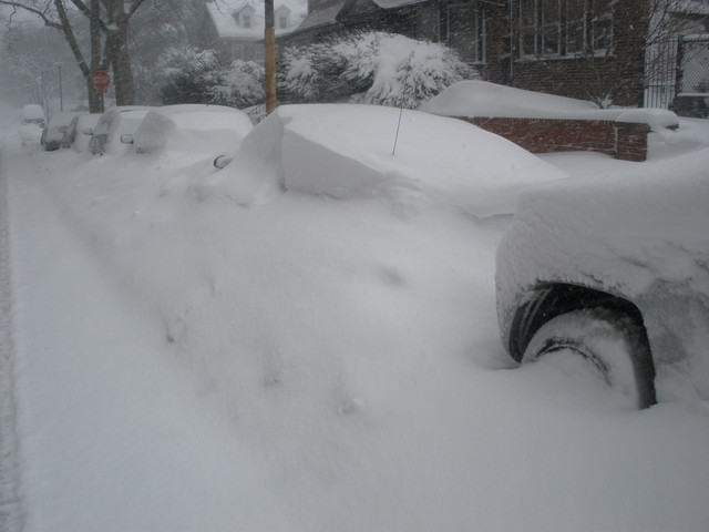
Figure 1. Cars buried in Philadelphia by “Snowmageddon”. Image credit: wunderphotographer TragicHipster.
Top 9 snowstorms on record for Philadelphia:
1. 30.7″, Jan 7-8, 1996
2. 28.5″, Feb 5-6, 2010 (Snowmageddon)
3. 23.2″, Dec 19-20, 2009 (Snowpocalypse)
4. 21.3″, Feb 11-12, 1983
5. 21.0″, Dec 25-26, 1909
6. 19.4″, Apr 3-4, 1915
7. 18.9″, Feb 12-14, 1899
8. 16.7″, Jan 22-24, 1935
9. 15.1″, Feb 28-Mar 1, 1941The top 10 snowstorms on record for Baltimore:
1. 28.2″, Feb 15-18, 2003
2. 26.5″, Jan 27-29, 1922
3. 24.8″, Feb 5-6, 2010 (Snowmageddon)
4. 22.8″, Feb 11-12, 1983
5. 22.5″, Jan 7-8, 1996
6. 22.0″, Mar 29-30, 1942
7. 21.4″, Feb 11-14, 1899
8. 21.0″, Dec 19-20, 2009 (Snowpocalypse)
9. 20.0″, Feb 18-19, 1979
10. 16.0″, Mar 15-18, 1892The top 10 snowstorms on record for Washington, D.C.:
1. 28.0″, Jan 27-28, 1922
2. 20.5″, Feb 11-13, 1899
3. 18.7″, Feb 18-19, 1979
4. 17.8″ Feb 5-6, 2010 (Snowmageddon)
5. 17.1″, Jan 6-8, 1996
6. 16.7″, Feb 15-18, 2003
7. 16.6″, Feb 11-12, 1983
8. 16.4″, Dec 19-20, 2009 (Snowpocalypse)
9. 14.4″, Feb 15-16, 1958
10. 14.4″, Feb 7, 1936Heavy snow events–a contradiction to global warming theory?
Global warming s
keptics regularly have a field day whenever a record snow storm pounds the U.S., claiming that such events are inconsistent with a globe that is warming. If the globe is warming, there should, on average, be fewer days when it snows, and thus fewer snow storms. However, it is possible that if climate change is simultaneously causing an increase in ratio of snowstorms with very heavy snow to storms with ordinary amounts of snow, we could actually see an increase in very heavy snowstorms in some portions of the world. There is evidence that this is happening for winter storms in the Northeast U.S.–the mighty Nor’easters like the “Snowmageddon” storm of February 5-6 and “Snowpocalypse” of December 19, 2009. Let’s take a look at the evidence. There are two requirements for a record snow storm:1) A near-record amount of moisture in the air (or a very slow moving storm).
2) Temperatures cold enough for snow.It’s not hard at all to get temperatures cold enough for snow in a world experiencing global warming. According to the 2007 Intergovernmental Panel on Climate Change (IPCC) report, the globe warmed 0.74°C (1.4°F) over the past 100 years. There will still be colder than average winters in a world that is experiencing warming, with plenty of opportunities for snow. The more difficult ingredient for producing a record snowstorm is the requirement of near-record levels of moisture. Global warming theory predicts that global precipitation will increase, and that heavy precipitation events–the ones most likely to cause flash flooding–will also increase. This occurs because as the climate warms, evaporation of moisture from the oceans increases, resulting in more water vapor in the air. According to the 2007 Intergovernmental Panel on Climate Change (IPCC) report, water vapor in the global atmosphere has increased by about 5% over the 20th century, and 4% since 1970. This extra moisture in the air will tend to produce heavier snowstorms, assuming it is cold enough to snow. Groisman et al. (2004) found a 14% increase in heavy (top 5%) and 20% increase in very heavy (top 1%) precipitation events in the U.S. over the past 100 years, though mainly in spring and summer. However, the authors did find a significant increase in winter heavy precipitation events have occurred in the Northeast U.S. This was echoed by Changnon et al. (2006), who found, “The temporal distribution of snowstorms exhibited wide fluctuations during 1901-2000, with downward 100-yr trends in the lower Midwest, South, and West Coast. Upward trends occurred in the upper Midwest, East, and Northeast, and the national trend for 1901-2000 was upward, corresponding to trends in strong cyclonic activity.”
The strongest cold-season storms are likely to become stronger and more frequent for the U.S.
The U.S. Global Change Research Program (USGCRP) began as a presidential initiative in 1989 and was mandated by Congress in the Global Change Research Act of 1990 (P.L. 101-606), which called for “a comprehensive and integrated United States research program which will assist the Nation and the world to understand, assess, predict, and respond to human-induced and natural processes of global change.” This program has put out some excellent peer-reviewed science on climate change that, in my view, is as authoritative as the U.N.-sponsored Intergovernmental Panel on Climate Change (IPCC) reports. In 2009, the USGCRP put out its excellent U.S. Climate Impacts Report, summarizing the observed and forecast impacts of climate change on the U.S. The report’s main conclusion about cold season storms was “ Cold-season storm tracks are shifting northward and the strongest storms are likely to become stronger and more frequent”.The report’s more detailed analysis: “Large-scale storm systems are the dominant weather phenomenon during the cold season in the United States. Although the analysis of these storms is complicated by a relatively short length of most observational records and by the highly variable nature of strong storms, some clear patterns have emerged (Kunkel et al., 2008).
Storm tracks have shifted northward over the last 50 years as evidenced by a decrease in the frequency of storms in mid-latitude areas of the Northern Hemisphere, while high-latitude activity has increased. There is also evidence of an increase in the intensity of storms in both the mid- and high-latitude areas of the Northern Hemisphere, with greater confidence in the increases occurring in high latitudes (Kunkel et al., 2008). The northward shift is projected to continue, and strong cold season storms are likely to become stronger and more frequent, with greater wind speeds and more extreme wave heights”. The study also noted that we should expect an increase in lake-effect snowstorms over the next few decades. Lake-effect snow is produced by the strong flow of cold air across large areas of relatively warmer ice-free water. The report says, “As the climate has warmed, ice coverage on the Great Lakes has fallen. The maximum seasonal coverage of Great Lakes ice decreased at a rate of 8.4 percent per decade from 1973 through 2008, amounting to a roughly 30 percent decrease in ice coverage. This has created conditions conducive to greater evaporation of moisture and thus heavier snowstorms. Among recent extreme lake-effect snow events was a February 2007 10-day storm total of over 10 feet of snow in western New York state. Climate models suggest that lake-effect snowfalls are likely to increase over the next few decades. In the longer term, lake-effect snows are likely to decrease as temperatures continue to rise, with the precipitation then falling as rain”.
Commentary
Of course, both climate change contrarians and climate change scientists agree that no single weather event can be blamed on climate change. However, one can “load the dice” in favor of events that used to be rare–or unheard of–if the climate is changing to a new state. It is quite possible that the dice have been loaded in favor of more intense Nor’easters for the U.S. Mid-Atlantic and Northeast, thanks to the higher levels of moisture present in the air due to warmer global temperatures. It’s worth mentioning that heavy snow storms should be getting increasingly rare for the extreme southern portion of the U.S. in coming decades. There’s almost always high amounts of moisture available for a potential heavy snow in the South–just not enough cold air. With freezing temperatures expected to decrease and the jet stream and associated storm track expected to move northward, the extreme southern portion of the U.S. should see a reduction in both heavy and ordinary snow storms in the coming decades.The CapitalClimate blog has a nice perspective on “Snowmageddon”, and Joe Romm of climateprogress.org
has some interesting things to say about snowstorms in a warming climate.References
Changnon, S.A., D. Changnon, and T.R. Karl, 2006, , “Temporal and Spatial Characteristics of Snowstorms in the Contiguous United States”, J. Appl. Meteor. Climatol., 45, 1141.1155.Groisman, P.Y., R.W. Knight, T.R. Karl, D.R. Easterling, B. Sun, and J.H. Lawrimore, 2004, “Contemporary Changes of the Hydrological Cycle over the Contiguous United States: Trends Derived from In Situ Observations,” J. Hydrometeor., 5, 64-85.
Kunkel, K.E., P.D. Bromirski, H.E. Brooks, T. Cavazos, A.V. Douglas, D.R. Easterling, K.A. Emanuel, P.Ya. Groisman, G.J. Holland, T.R. Knutson, J.P. Kossin, P.D. Komar, D.H. Levinson, and R.L. Smith, 2008: Observed changes in weather and climate extremes. In: Weather and Climate Extremes in a Changing Climate: Regions of Focus: North America, Hawaii, Caribbean, and U.S. Pacific Islands [Karl, T.R., G.A. Meehl, C.D. Miller, S.J. Hassol, A.M. Waple, and W.L. Murray (eds.)]. Synthesis and Assessment Product 3.3. U.S. Climate Change Science Program, Washington, DC, pp. 35-80.
Jeff Masters