Over a century ago, the city of San Diego offered Charles Hatfield the equivalent of $250,000 in today’s money to rescue it from a drought that had depleted the Morena Reservoir, which provided its drinking water. Hatfield, who referred to himself as a “moisture accelerator,” had developed an early form of geoengineering mechanism that sent little puffs of a vaporized chemical solution skyward. He claimed those puffs could squeeze rain from the stingy clouds above and fill the reservoir anew. If his technology proved to be a boondoggle, the parties agreed, he wouldn’t get paid.
Hatfield set his device in motion at the end of December 1915. Over the course of the following month, San Diego was inundated with an extraordinary amount of rain, raising the reservoir level by nearly a foot and a half in just the first two weeks. Hatfield was both delighted and smug, making the rounds to demand his payment. Soon, however, a second downpour caused the San Diego and Tijuana rivers to overflow, flooding the slightly inland Mission Valley and the small farming towns within it. About a week later, a third, unprecedented deluge knocked down the Otay Dam and wiped out the Otay Valley, leaving approximately 20 casualties in its wake.
Hatfield maintained that he had performed his job as promised — even in the face of, well, mass murder accusations. Nonetheless, both officials in 1916 and historians today remain unconvinced that Hatfield’s experiments actually generated the amount of precipitation that decimated the region. In fact, it’s much more likely that it was the product of something that wouldn’t be named for another 80 years: The atmospheric river, Southern California’s fickle rain goddess, which delivers a great deal of the region’s precipitation and almost all of its devastating floods.

Here’s how pretty much all rain arrives in the desert climate of San Diego County, the region of 3 million people at the border of California and Mexico. Under the right atmospheric and oceanic conditions, a trail of water vapor gets yanked up into the sky from the swath of the Pacific Ocean lying in the tropics by a cyclone. It is carried east on the storm’s coattails all the way to coastal land. It’s a very long trail; one can span half of the Pacific and carry a quantity of water exceeding that of the Mississippi River. When that atmospheric river runs up against the mountains framing the eastern edge of San Diego County, all its moisture gets squeezed out of it onto the land below, like wringing out a soaked sponge.
In the best-case scenario, that moisture nourishes the region. All of Southern California depends on atmospheric rivers to fortify its water supply. An absence of atmospheric river activity, however, can yield something like the 2013-2015 drought, depleting reservoirs and parching landscapes. Now if that airborne procession of water vapor is just a tiny bit wetter than normal and if conditions on land are just a tiny bit unfavorable — plantlife stripped away by fire, for example, leaving the earth with nothing to keep it from collapsing in a landslide — that precipitation can result in a disastrous deluge similar to the ones Hatfield most likely didn’t summon.
There are pile-on consequences, too. The risk that a California wildfire will go from bad to worse is subject to several variables — for example, the makeup of the vegetation serving as kindling, which is influenced by duration and intensity of recent rainfall, and how dry that greenery can get. A particularly wet year, like 2019, creates a lush, verdant carpet of grasses and brush and flowers. The much-Instagrammed “superbloom,” in which hillsides are draped in veils of bright green and sparkle with luminous orange and red and yellow blossoms, is one of the more beautiful consequences of a winter marked by particularly heavy atmospheric rivers. Then, summer comes, and the sun gets hotter and the rains disappear, and all that springtime frondescence dries up into great heaps of fuel for any errant spark.

These days, an additional variable has entered the mix: climate change. An atmospheric river is the product of a particular confluence of ocean currents, atmospheric pressure, and temperature, conditions that are very much influenced by warming. And so, as the globe heats up, the behavior of the phenomenon that decides whether California thrives or suffers becomes increasingly erratic — one year could have so many atmospheric river events that a neighborhood drowns in landslides, another could have so few that one of the largest population centers in the country finds itself in a fire-ready drought. On that note, a team of Columbia University scientists recently determined that the American West is suffering through a climate change-influenced drought that began in the year 2000. In fact, if the pattern of arid conditions continues for the better part of the next decade, the “emerging megadrought” could rival any other in the past 1,200 years.
San Diego County is made up of so many wildly diverse little ecosystems that the impact of even a slight fluctuation in atmospheric river activity can produce a wide variety of threats, particularly in areas already facing challenges. The town of Imperial Beach, which sits on the Pacific just north of the Mexican border, and the Native American reservation of La Jolla, perched on the side of Palomar Mountain, look nothing alike in ecology or population. But the locales — situated on opposite sides of the county — do share one common enemy: the rain, be it too withholding or too generous.
When Paloma Aguirre, mayor pro tempore of Imperial Beach, was elected to the town’s council in 2018, she was the first Latina woman councilmember in a community that’s 51 percent Hispanic. It’s also one of the last, as she puts it, “truly working-class” beach towns on the Southern California coast, with about 20 percent of its population living at or below the poverty level. Years back, as an active surfer, she kept hearing stories of Imperial Beach residents suffering terrible maladies from swimming or surfing in polluted water: an ex-Navy SEAL who contracted a flesh-eating bacteria; a kid with an orbital eye-socket infection that threatened to pass into his brain. And so in 2006, she got involved in water cleanup activism.
Aguirre’s growing challenge these days is that low-lying Imperial Beach is besieged on three sides by water: To the west lies the Pacific Ocean; to the north, San Diego Bay; and to the south, the Tijuana River Estuary. Last April, following a very, very wet winter, the protected land that makes up the estuary’s preserve was studded in daisies and rich with greenery. Small birds and lizards skittered from leaf to leaf and across the ground, more like large insects than any other sort of fauna. The air was a little damp and heavy with moisture rising from all the plant life. But if you inhaled just a bit too deeply, you noticed that it also smelled bad — like a public bathroom, but earthier. It’s the sewage problem, and the reason why Aguirre has recently had business in Mexico.
Tijuana lies about five miles south of Imperial Beach — from the estuary preserve you can actually see, across the border, the hills blanketed in houses. The infamous border town is now Mexico’s third-largest city, and it’s grown one and a half times over since 2000. The city’s sewage infrastructure has, to put it delicately, not kept up. To put it indelicately, there are thousands of tons of human waste pouring into both the Pacific Ocean and the estuary almost every day. Both the tides and the river flow north, downhill, into Imperial Beach.
The problem is multifold: First, there’s the issue of Tijuana shantytowns that aren’t hooked up to the municipal sewage treatment system at all, and are dumping untreated waste into the city’s sewers. Second, there’s the decrepit, overloaded infrastructure. The International Border and Water Commission is supposed to be responsible for the pipes that overlap the estuary. Pipes frequently break or overflow as burdens on the system have increased, and no funds have materialized to fortify it. And third, there’s the rain, of course.
Surfers, left, take their chances in choppy waves at Imperial Beach. To its east, is the Tijuana River Estuary Preserve, which leads to the Mexican border. Grist / Eve Andrews
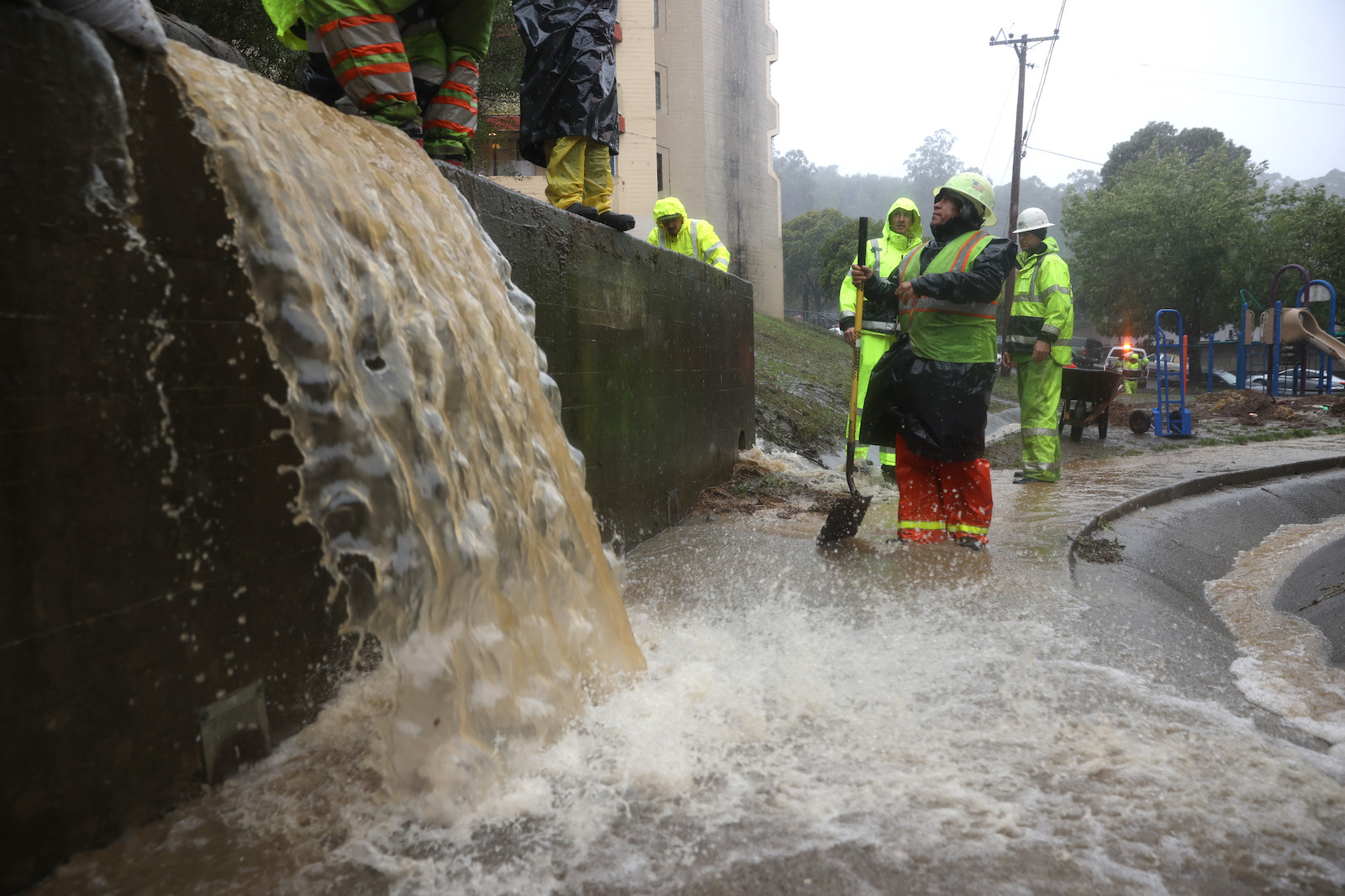
The geography of Imperial Beach does little to naturally mitigate the situation: It’s completely flat, all at sea level. When an atmospheric river event hits the city of Tijuana, everything is washed down the slopes of its steep hills and straight into either the arroyo that feeds into the Tijuana River Estuary, or directly into the Pacific Ocean. Aguirre describes the relationship between the ongoing influx of human waste and chemical contamination and the heavy rains as being as if “you had cancer, and then you’re hit with this acute pneumonia.” To add insult to injury, the beach, because of its tourist appeal, is Imperial Beach’s main economic engine. In recent years, it has been closed an average of 300 days per year.
Imperial Beach parents also claim the pollution causes their children to cough, vomit, and develop rashes. Bethany Case’s house, about six blocks from the estuary park and a little over a mile from the shore, is adorned with relics of her family’s affection for the ocean: A bucket of seashells sat by the door, surfboards lay stacked against the back facade of the house, the walls were covered with squares of beachy art. Case’s young daughter ran around in a goldenrod-colored sweatshirt paying homage to her junior lifeguard training.
After a heavy rain or an infrastructure breakdown, the smell comes in waves, Case explained. “What happens here in our neighborhood, is we get it first,” she said, gesturing toward the estuary a few blocks away. The winter of 2019 saw 25 percent more rain than usual — and more smell.
Case and her friend Shannon Johnson are part of the coalition Clean Border Water Now! which is facilitated by the Surfrider Foundation, an ocean and beach preservation organization. They’re pushing for structural improvements to the wastewater treatment plant at the border, including an additional catch basin. The United States-Mexico-Canada Agreement, signed in January, includes $300 million to address cross-border contamination issues; but funding, which is controlled by the U.S. Environmental Protection Agency, is far from guaranteed in the current coronavirus-dominated political and economic climate. In any case, any money would only address sewage overflow from the Tijuana River and the estuary; the deluge that comes in from the ocean is beyond its control.
In 2019, super-high January tides called king tides raised sea levels around Imperial Beach by as much as 7 feet over their normal height. These tides, fueled by flooding from more intense atmospheric river activity, are capable of bringing sewage-laden ocean water straight into homes. Concurrently, intense atmospheric river rains flood the Tijuana River and the estuary, engulfing Imperial Beach streets from all sides. After such inundation, the estuary “looked like a lake,” Aguirre said. “It was completely covered in water — it was sewage, it was contaminated, it was stinky.” It was a picture of what she fears is the shape of things to come.
Researcher Laura Engeman, along with a team lead by Mark Merrifield at the Center for Climate Change Impacts and Adaptation at Scripps Oceanographic Institute, half an hour north of San Diego, is well aware of the increasing intensity and unpredictability of these atmospheric river impacts. They have been working to develop and install instruments to help predict when storms, tides, or a combination of both threaten to flood Imperial Beach. In November of 2018, they put those tools into action, planting them at different points along the town’s coast.

“For us on the West Coast, we’re not only dealing with actual ocean water levels rising, we’re also dealing with the frequency of coastal storms and wave activity as well as extreme events,” Engeman said. “We already get these king tide events.” She predicts they will only be more severe as time goes forward.
It’s this combined effect — when Pacific storms, such as the tropical cyclones that carry atmospheric rivers, coincide with extreme tides — that keeps Imperial Beach Mayor Serge Dedina up at night. On a walk along the San Diego Bay wetlands to their western edge, where they’re separated from the ocean by a strip of low-lying land, he pointed out some of the houses that would be hit hardest by such an event.
“It’s very clear that it’s not just climate change, it’s climate instability,” he said, before describing a storm that hit the area in January 2019. “When I walked out on the beach that morning, it was like this wild animal — it was just different.”
According to Dedina, there’s nowhere near the money in the Imperial Beach coffers that would begin to pay for the kind of infrastructure reinforcement or relocation that encroaching water would require. (That situation is certainly not likely to improve due to coronavirus’ impact on tourism in the months to come.) This is why the town was the first municipality to file suit against major oil companies for climate damages back in 2017.
“People have said, ‘Oh, it’s a gimmick’ or ‘It’s ideological,’ but it actually isn’t,” Dedina said. “We have no way to pay for anything that we’re looking at doing.” He added that the state of California is also cash-strapped and he isn’t expecting any help from the feds. “A very small percentage of the world’s companies had a significant impact on emissions,” he explained. “So the argument we’re making is that they should pay for it, and they should help us pay for the damage it caused.”
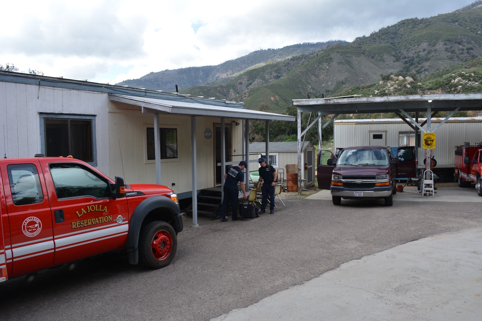
To get to the fire station of the La Jolla Band of Luiseño Indians, you follow Route 76 up the east edge of the Pauma Valley, not far from the Palomar Observatory, along some steep and jaw-clenching turns. You will pass a grove of citrus trees, glossy globes of yellow and orange decorating stout greenery pruned into cubes; next a nursery of palm trees, rows planted so tightly they look like Seussian cornfields; and then all of a sudden you’ll have climbed far enough to see the whole valley spread out below you in a chartreuse-and-olive patchwork. You make a too-sharp left on a narrow road that seemingly leads straight into the foot of the forested mountain ahead. Suddenly you realize half the trees on the mountainside are dead, pale shards poking up at a pale sky, clearly having been taken out by a significant fire.
The station itself is a collection of ramshackle structures sprinkled on both sides of the road: an open-walled aluminum shelter for three trucks, a trailer, a plywood two-room shack surrounded by relics of the department’s history. Hulking red cabs with rounded contours give away their vintage.
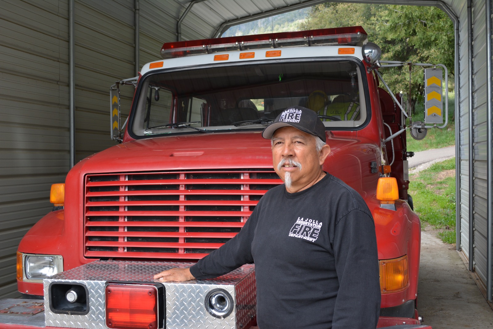
The La Jolla fire department, left, was volunteer-only until three years ago. It’s led today by Fire Chief Wesley Ruise, Jr., who took over the job after his father retired roughly 20 years ago. Grist / Eve Andrews
Wesley Ruise, Jr. has been the fire chief of the La Jolla Band since about 2000, when his father, Wesley Sr., retired. Both had served in the U.S. Forest Service, and Ruise Jr. took over for his father shortly after his own retirement from the service. “I didn’t apply for it or ask for it,” he explained. “It was just, ‘You’re next in line with the most experience.’” Ruise the elder had founded the fire department in 1985, with a handful of volunteers, and it remained volunteer-only until 2017, when, after a decade-long campaign, enough grants and funding came through for his son to hire some full-time, paid staff. That campaign was launched in the wake of a blaze dubbed the Poomacha Fire, which decimated a huge swath of La Jolla land, including a third of its homes.
Around 3 in the morning on October 22, 2007, a house in what’s known as the Poomacha section of the reservation caught fire. The blaze quickly raced down the side of Palomar Mountain, accelerated by Santa Ana winds. The younger Ruise and his volunteer crew rushed out into the night to drive it back, equipped with one old, refurbished fire engine and a couple of bulldozers to dig trenches to block the fire from progressing. “It was all old equipment that someone else had gotten rid of because it ran its course,” Ruise said.
“We’re lucky that people made it out alive without any serious injury,” he continued. “People were able to escape, to get out and go by some way, some warning — whether it was their dogs barking, or the smoke alarms going off in their houses.”
The stage for the Poomacha fire had been set about 20 months prior. The winter of 2005 had been marked by catastrophic rain events across the San Diego County area that caused mudslides, flooding of the normally trickling San Luis Rey River, and even one fatality due to a falling tree. Following that, both 2006 and 2007 were bone-dry. Some 10 years later, in 2017, the Desert Research Institute at the University of Nevada established a strong if seemingly counterintuitive correlation in Southern California between heavy atmospheric river activity and more expansive wildfires in the following year. The premise is, as people have long observed: Heavy rain comes along and cultivates the kind of brushy, low-to-the-ground greenery that, after a drier year, makes ideal wildfire kindling.
Inside the fire department’s trailer, Ruise sat at a metal desk that’s been repurposed as a kitchen table in the dim communal room for the crew. “You can see we’ve had a lo-ooo-ot of rain,” he said, gesturing out the tiny window over the stove in the spring of 2019. “You can see how much grass is out there right now. And typically that’s what’s needed to get a fire started.” The white oaks were crowned with blue-green leaves, little sparks of flame-colored petals shoot out from among the shin-brushing grass, and even the desert-y brush is glowing with chlorophyll. And yet it’s easy to see how quickly this verdant greenery could turn to straw under a hot, scorching sun.
Ruise and his crew regularly work to create fuel breaks across the reservation by thinning out vegetation and clearing dead underbrush from forested areas to prevent inevitable smaller fires from gaining momentum and erupting into something like the Poomacha catastrophe. But that kind of trimming and clearing can be daunting because the grass never stops growing.
The La Jolla Band is, as are other Native American tribes, in an awkward position. Their carefully drawn patch of 9,998 acres is the only place that they are guaranteed the right to live according to their customs, by way of treaty with the U.S. government. Leaving is not an option. So if you can’t move your home, how do you best protect it? With money. La Jolla makes most of its modest income by permitting visitors to marvel at the beauty of its territory. A small campground, a zipline, and a general store — that, as of less than a year ago, houses a tiny gambling operation with 75 slot machines — make up its entire recreational tourism operation.
Money from the sprawling casino resort at the neighboring reservation of Pala is what allowed the tribe to build a new firehouse in 2008. In addition to the revenue brought in from slot machines and card games, tribes that have gaming on their reservations are entitled to federal money to beef up their fire infrastructure so that they can protect visiting patrons.
“Tribes like Pala, who have gaming and are able to leverage that into important benefits for the community, are the exception,” explained Shasta Gaughen, environmental officer for Pala. The tribe has been able to afford a sprawling fire station with airy vaulted ceilings arching over a small fleet of impressive new rigs — including a special truck for rescue from high waters in extreme floods. In California, tribes with gaming also put money into a communal pool that gets shared by all the state’s tribes.
Ordinarily, the San Luis Rey River on Pala land is a roughly 10-yard-wide vein of cracked, sandy mud dry enough to cross, if you don’t mind some water squelching up around your boots. But in February 2019, an atmospheric river event brought torrential rains that poured down the mountainsides framing the valley. The riverbed flooded so intensely that a woman trying to drive across it got swept a mile or two down the road, ending up behind the casino.
The Pala Reservation, too, works diligently to cut back all the foliage that results from these floods and to carve deep furrows into the ground to create natural blocks to a fire’s spread. That, of course, requires adequate manpower and the proper equipment. Under the Trump administration, federal funding for climate adaptation projects has become scarce, to say the least. Gaughen shared an eye-opening anecdote about a four-year EPA grant the tribe won to study climate impacts in 2016. It immediately stopped paying out when Trump took office. Since then, she said, any funding application with “climate change” in it has been blackballed. All of the funding for her work currently comes from hard-won grants from the state of California or nonprofit organizations.
Leaving the La Jolla fire station last spring on the way back to the city of San Diego, one could see the sign for the band’s zipline, only it had been roped off due to the winter’s flooding. It was followed by a sign directing visitors to the campground — also closed at that moment, also due to flooding. It is achingly clear that the very means that the tribe has to fund its own protection against the elements are endangered by those very elements.
And now — as with other Native casinos, including the one on the Pala Reservation, the fledgling La Jolla casino is currently closed for business because of the COVID-19 pandemic. The campground remains shut down, too. The sudden lack of gaming and recreation income means less money for any semblance of climate adaptation projects on reservations. At the same time, there’s an expectation that the demand for federal aid for coronavirus relief will mean an even sharper deprioritization of much-needed funding for any climate-related programs.
“It wouldn’t surprise me in the least, especially under the current administration, if those program areas are not going to be a priority,” Gaughen said. “In fact, if they don’t get cut, I would be shocked.”
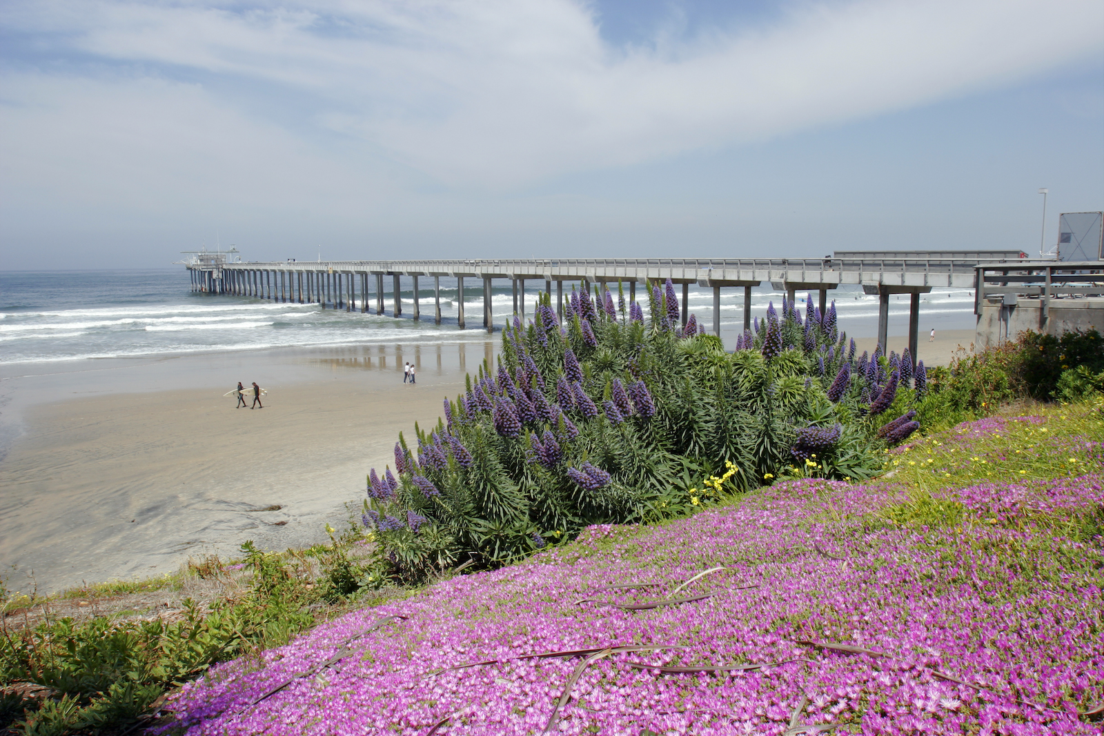
The Scripps Institution of Oceanography, coincidentally in the coastal town of La Jolla, is perched on a cliff directly above the ocean, almost as if it’s keeping vigil over the Pacific. It’s home to meteorologist Marty Ralph’s Center for Western Weather and Water Extremes, arguably the leading research laboratory addressing how rising temperatures are affecting the frequency and behavior of atmospheric rivers.
The atmospheric river is “our local meteorological benevolent dictator,” said Forest Cannon, a senior researcher in Ralph’s lab. “Climate change will make this dictator more temperamental. But there are still a lot of questions around what will end up happening, with the new reality that there’s more energy and more moisture available in the atmosphere.”
The Ralph Lab is working on atmospheric river “reconnaissance,” which involves partnering with the U.S. Air Force to drop little devices — “they look like Pringles cans,” Cannon said — that record temperature, air pressure, and moisture within an atmospheric river. Those measurements will help improve forecasting for incoming deluges, or the lack thereof, on behalf of affected communities.
The next, or rather, simultaneous, challenge is figuring out how to respond to those forecasts. That’s where the work of Amber Pairis, a Scripps scientist, and her Climate Science Alliance, a San Diego-based coalition of scientists, policy experts, and community leaders, comes in. “Often, by the time science gets published, it’s a couple years old,” Pairis explained. “With climate adaptation — responding to climate risks — we need that information now. We need to find a way to provide it in real time, so that it is actually a service to the people who need it in that moment.” Pairis has, for example, been communicating with the La Jolla tribe to convey the risks of fluctuating precipitation and help devise ways to deal with it — like putting in the fire breaks Ruise and his crew dig to limit the spread of a fire.
What does it all add up to? In effect, what’s being created is a feedback loop in which the data collected can allow people to respond. In addition to the little Pringles cans being dropped into atmospheric rivers, there are the sensors that the Scripps Climate Change Impacts and Adaptation Center has planted along the Imperial Beach shore. Among them are a buoy floating out at sea, a LIDAR sensor buried in the sand, and a wave sensor attached to the pier which, taken together, will provide real-time predictions for high tides and coastal flooding so that people can prepare and plan for inundation.
More than a century ago, the city of San Diego put its faith in an individual and his single “invention” and attempted to end a drought. Now, it’s understood that there’s no controlling the weather. The clouds and the rain are changing, and will continue to. Adaptation to climate change will take a lot more people — researchers, community leaders, and residents — banding together to observe and determine the best courses of action. It’s hoping for the best, but preparing for the worst — not god-level work, but it brings it back into human hands.