This story was originally published by Wired and is reproduced here as part of the Climate Desk collaboration.
Scientists, environmentalists, and anyone who lives within a hundred miles of the winding Mississippi River will tell you — have told you, repeatedly, for 150 years — that efforts to tame the river have only made it more feral. But scientists would like more than intuition, more than a history of 18th-century river level gauges and discharge stations, more than written and folkloric memory. They would like proof.
Luckily, rivers inscribe their history onto the landscape. Which is why Samuel Muñoz, a geoscientist from Northeastern University, found himself balancing on a pontoon boat with a hole in the middle, trying to jam 30 feet of aluminum irrigation pipe into the muddy bottom of a 500-year-old oxbow lake. Muñoz and his team thought that if they could just pull up good cores of that mud, the layers would be a chronology of forgotten floods — a fossil record of the river’s inconstancy made not through petrification but implication.
Basically, the Mississippi meanders. Sometimes the river curves around so tightly that it just pinches off, cutting across the peninsula and leaving the bigger curve high, if not dry. That parenthesis of water alongside the main channel is an oxbow. In a flood, water churns up chunks of sediment and spreads into the oxbow. When the flood waters recede, the layer of coarse sediment sinks to the oxbow’s bottom, where it remains.
So Muñoz’s team humped their pontoon boat all the way from Woods Hole, Massachusetts to three oxbows whose birthdates they knew — one from about 1500, one from 1722, and one from 1776 — and jammed pipe into the lakebed with a concrete mixer. “It vibrates so hard, your hands fall asleep,” Muñoz says. “And then you have 300 or 400 pounds of mud you’re trying to get back up.” But it worked.
The cores were a map of time, with today at the top and the oxbow’s birthday at the bottom. In between: A peak of the radioactive isotope cesium-137 marked 1963, when humans started testing nuclear bombs. Using technique called optically stimulated luminescence to date, roughly, when a layer was last exposed to sunlight, they spotted classic floods, like 2011, which caused $3.2 billion in damages, and 1937, which required the largest rescue deployment the U.S. Coast Guard had ever undertaken.
The important part, though, was that the characteristics of the layers for floods they had numbers on could tell them about the magnitude of floods they didn’t. They got 1851, 1543, and on and on.
Then Muñoz’s team checked their work against another record: tree rings. Inundate an oak tree for a couple weeks and that year’s growth ring will show damage at the cellular level. So they took core samples from trees, living and dead, in the Mississippi flood plain — the oldest going back to the late 1600s. The ring damage matched. Not exactly, maybe, but close enough. They knew they were seeing floods for which no one had numbers. Muñoz’s team had created a record of Mississippi River floods two centuries older than any other. They published that work in the journal Nature on Wednesday.
Here’s where the fun part starts. Muñoz’s team then compared those floods with meteorological data — hunting for some link between flooding and climate. They especially looked at temperature changes on the oceans — El Niño events in the Pacific and Atlantic Multidecadal Oscillation. “There’s this really obvious increase in both how often the river has been flooding over the last century and how big those floods were,” Muñoz says. “The default explanation is that there’s something going on with the climate that would explain that.” There was: More El Niño meant more floods.
So climate change causes floods, right? Hah! Too easy. Muñoz’s group ran a statistical model, based on the climate over the entire period of time they now had flood records for, estimating how much more worse flooding should have gotten based on climate change alone. “It comes up with a little bit of an increase, like a 5 percent increase in how big the biggest floods should be,” Muñoz says. “But not all the increase.”
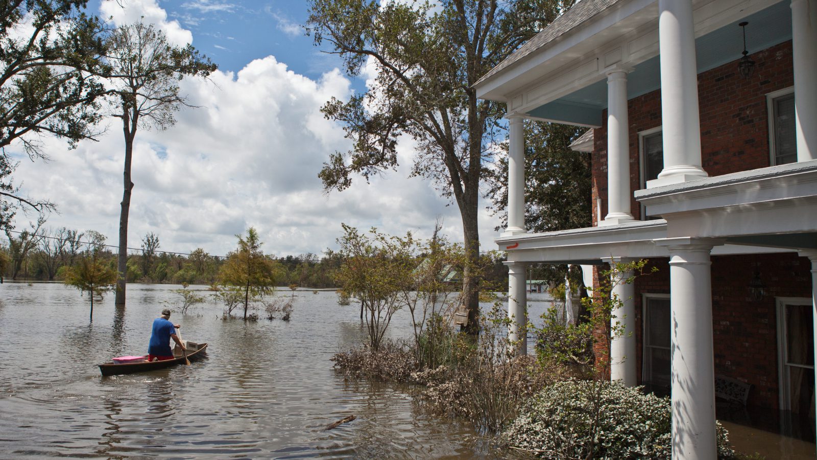
Overall flood risk has gone up 20 percent, the team says. But 75 percent of that risk comes from human engineering of the Mississippi for navigation and flood control. In other words, it’s our fault.
After a particularly devastating flood in 1927 — 637,000 people lost their homes, perhaps up to 1,000 killed, $14 billion in period-adjusted damage — human beings deployed the U.S. Army Corps of Engineers to wage all-out war on nature to protect industry, farms, and trade. People tried to warn the government even as construction began on the Mississippi’s infrastructure — channelization, dredging, dams in the upper stretch, and along the middle and lower levees, concrete mats along the banks called revetments, and gates.
“All that increases the amount of water and the speed that water goes during a flood. What we’re saying is, we can’t explain the increase we’re seeing with climate alone,” Muñoz says. “But for the first time, we can go back further, to a state in which the river wasn’t dominated by human activities. We can really show that the way the river behaves today is not natural.”
Even that look at the prelapsarian Mississippi may not change much. Warnings that flood control would lead to uncontrolled floods date back to at least 1852, when a famous engineer named Charles Ellet warned in a report to Congress that the whole idea was going to lead to disaster. Yet the U.S. Army Corps of Engineers’ Mississippi River and Tributaries Project remains in full, multi-billion-dollar effect. (Representatives for the Corps of Engineers did not return multiple requests for comment.)
Now, Muñoz’s inferential datasets don’t convince every river researcher. Bob Criss, a hydrogeologist at Washington University at St. Louis, says he doesn’t completely buy Muñoz’s team’s particle-size correlations and tree-ring cell biology. “It’s just a bunch of voodoo and sound bites,” Criss says. “I certainly don’t object to his conclusion. But I don’t think it’s robust.”
Criss definitely does buy the idea that engineering has made flooding worse, though. He says straight-ahead numbers like stage measurement (the height of the river) are enough to tell you that. Levees upriver send more water downriver. Revetments move that water faster. What might have been slow-spreading floodwaters when they were unconstrained turn into neighborhood-destroying mini-tsunamis when they burst all at once from behind failing levees.
“That’s what Charles Ellet was saying 160 years ago. This is the problem with the Army Corps. It’s like a protection racket. They just squeeze the river, make more floods, and then say, ‘Oh, let us help you, you need more help, the floods are worse,’” Criss says.
To be fair to Muñoz’s measurements, paleoflood hydrology on the Mississippi ain’t easy. (Hence the pontoon boats.) Rivers in the American Southwest that run through bedrock and canyons, for example, leave much more evident traces — sediments and other stuff that researchers can more easily excavate. That’s how paleohydrologists like Victor Baker, at the University of Arizona, can produce a 2,000 year record of Colorado River floods and a 5,000-year record of floods on river systems in Arizona. (Perhaps it will not surprise you to learn that attempts to regulate those floods has worsened them, as has climate change.)
And Baker buys what Muñoz has come up with. “Levees protect against little floods. If you have a super big flood that exceeds the capacity of the levee, the levees make that worse,” he says. There have been bigger floods than people remember — but the landscape recorded them. And if humans learn to play those recordings back, maybe we can find a new way to get ready for the waters yet to come.
A message from
Your support keeps our climate news free.
Grist is the only award-winning newsroom focused on exploring equitable solutions to climate change. It’s vital reporting made entirely possible by loyal readers like you.
At Grist, we don’t believe in paywalls. Instead, we rely on our readers to pitch in what they can so that we can continue bringing you our solution-based climate news. Donate today to keep our site free.