For the first 18 years of my life I lived along the final 17-mile stretch of the Passaic River. That’s the dirty, ugly part of the river that passes through the most crowded, industrialized part of the United States.
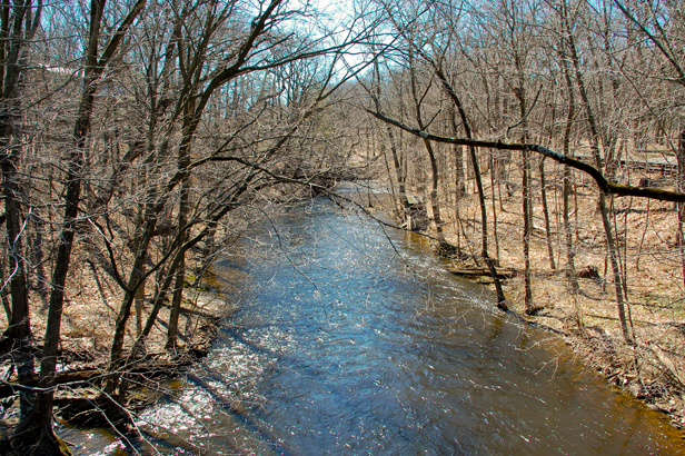
The Passaic forms the western border of my home town: North Arlington, New Jersey, a tiny borough just a few miles north of the river’s mouth in Newark. Our house sat on a steep slope above the river. In the winter, when the oak and maple trees were all bare, I could see the water from our front porch. Sometimes in summer, when a flood tide overwhelmed the river’s sluggish current, the Passaic would smell faintly of the sea.
The Passaic was my home town river, but I didn’t have much to do with it as a kid. I crossed over it often enough, every time we visited my mother’s family, who lived on the other side. But I rarely played by the Passaic. I never fished it or took a boat out on it. I certainly didn’t swim in it. I didn’t really know the river. I just knew that it gave me the creeps.
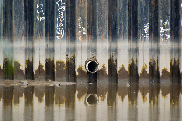 The lower Passaic flows through the most densely populated, heavily industrialized area in the country.Photo: Mary Bruno
Like the state it flows through, the river has a serious image problem. The Passaic is as historic as New York’s storied Hudson, and in some places — the 77-foot-high cascade in Paterson, for one — it is just as majestic. But most people, even some New Jerseyites, have never heard of the river. Those who have know it only as one of America’s most polluted waterways. It’s hard to bond with a river like that.
The Passaic is a poster child for rivers — for nature — everywhere. The river had been the lifeblood of the region, the source of food and power, the playground of the rich, the avenue of transportation, communication and commerce. The first white settlers sailed up the Passaic in 1662 and founded Newark, the nation’s third oldest city, on its banks. The river’s abundant charms fueled an explosion of growth and industry that transformed the fledgling United States into a global manufacturing powerhouse. But in time the industrial revolution it spawned would poison and betray the Passaic. By 1952, the year I was born, the river’s beauty and majesty were dim and distant memories. Its lower stretch was a toxic canal. The Passaic wasn’t a source of wonder and delight, or even interest anymore. For a whole generation, my generation, it inspired fear, revulsion, and denial instead.
The river wasn’t fearsome in any traditional sense. It didn’t rage or thunder. It didn’t loll along and then suddenly turn into a boil or hurl itself over a cliff — not this far downstream anyway. It wasn’t icy cold or booby trapped with eddies. It wasn’t even that wide; a dog paddler like me could make it all the way across. But the river scared us just the same. It scared us in a deep down creepy kind of way.
We were afraid of its impenetrable darkness. We were afraid of its industrial smell. We were afraid of the things that lived beneath its surface and the things that had died there. We were afraid of spotting a hand or a head bobbing in the rafts of garbage that floated by. We were afraid of submerged intake valves that sucked water into the factories along the banks. We were afraid of the river’s filth. It wasn’t the kind of filth that came from playing football with your friends. It was grownup filth. The kind that scared the blue out of water and coated the riverbank with oily black goo. It was the kind of filth you could taste; the kind that could make you sick, maybe even kill you. We were afraid of getting splashed with river water or of touching river rocks. We were afraid of falling in or of — God forbid — going under. We were afraid of the river’s anger at being so befouled, and afraid, most of all, of the revenge we felt certain the river would exact.
Surely, I thought, there must be more to my home town river than the oily, garbage-strewn slough that I remembered.
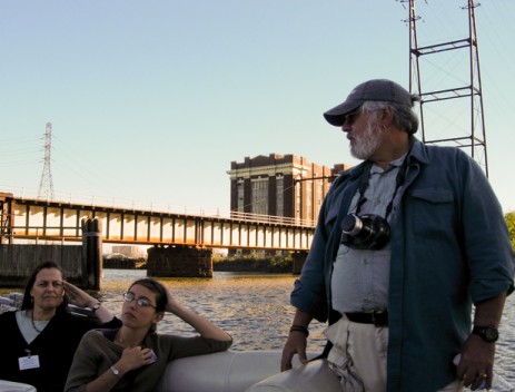 “Our job is to make advocates of people,” said former NY/NJ Baykeeper executive director Andy Willner.Photo: Mary BrunoAndy Willner, recently retired Executive Director of the N.Y./N.J. Baykeeper Association, is passionate, generous, cocky, fearless, and a bit bombastic. I love him. He says the N.Y./N.J. Metropolitan Area is a “big region” with “low environmental self-esteem.” His mission is to awaken citizens to regional treasures like the Passaic. He says that people don’t know the Passaic anymore, that the river is a stranger to them, and that you can’t care about something that you don’t know. He invited me to join him on a Passaic River boat ride.
Our boat was a 16-foot Aqua Patio. It looked like a floating hot tub, all white with a high freeboard and banquette seating, ideal for the civilian river trips that the Baykeeper regularly runs up the Passaic. The two-hour tour took us about three miles upriver, from the mouth in south Newark to the New Jersey Performing Arts Center at the north end of downtown. It was the first time I had ever actually been out on the Passaic.
I took a seat in the bow with a pair of environmental engineers from Pennsylvania and three attorneys from the Rutgers Environmental Law Center. Janice and Martin, a retired couple from New York, were squeezed into the stern alongside two researchers from the New York Academy of Sciences, who were studying the ecology of New York Harbor.
Skipper Bill Sheehan had the helm amidships. He was sturdy and gruff with a shark tooth necklace and a bushy red moustache the color of sunset that completely obscured his upper lip. He leaned against the gunwale, just in front of Janice, one hand on the wheel. He had the look of a cop, or a bartender, or the ship’s captain that he was. The look of someone who is comfortable being in charge.
Andy, our host, was a sunnier presence. He had a full gray beard and a thick shag of salt and pepper hair. A seafaring rabbi. A 35mm camera swung from his neck. He used his free hand — the one that wasn’t gesticulating — to brace the camera against his middle-aged paunch. He had made this trip upriver on many, many occasions, but he snapped pictures with the eagerness of a first-timer. He pointed out his favorite bridge. He marveled aloud at the play of sunlight on the glass facades of the new office towers along the shore. Wonder lives next to outrage in his heart.
We set out from the Passaic Valley Sewerage Commission’s massive sewage treatment plant on the shores of Newark Bay. The 172-acre complex of circular tanks, pipes, pumps and stacks processes waste for 1.3 million residents in New Jersey’s Passaic, Bergen, Essex, and Hudson counties.
Once we cleared the dock, Andy unfurled a nautical chart and located our position in the labyrinth of bays, tidal inlets, islands, and marsh. Raritan Bay was below us, linked to Newark Bay by the Arthur Kill, a tidal strait that separates New Jersey from Staten Island. Across Newark Bay to the east lay the Meadowlands, the vast salt marsh that is home to the Hackensack River. Above us, and well within view, were the mouths of the Hackensack and the Passaic. The two rivers flow down from the north and squeeze the last bite of land between them into a chubby, muddy “V” called Point No Point before they disappear into Newark Bay.
Andy straightened up, and with a sweep of his right arm, lassoed up the entire view. “All these bays were much larger,” he said. “They were all extraordinary wetlands. The Passaic was one of the most bountiful rivers in the whole system, this estuarine stream with tributaries coming into it and a marsh system all around it.”
I strained to picture the scene that Andy was describing. Like so much wild habitat in New Jersey, the wetlands that surround Newark Bay have been manhandled over time. In most places their transformation is so complete that discerning the natural features of the landscape is an exercise in extreme imagination. The once sinuous outline of Newark Bay, scalloped by coves and inlets and the mouths of its tidal rivers and creeks, is now ruler straight thanks to a century-long parade of large scale public and private development projects. “You can see how geometric the shoreline is,” said Andy, tapping the chart. “These are big fills.”
The transformation of the Newark Meadows began in 1914 when the city of Newark, hungry for real estate, began reclaiming the marshland along the western shore of Newark Bay. Port Newark came first. The city dredged a mile-long shipping channel in the bay. They mixed the dredgings with garbage and ash and heaped the malodorous blend on top of the salt marsh until the landfill was firm enough to support the docks and warehouses that followed. By 1974, the Newark Meadows had completely disappeared, buried beneath the Port Newark/Elizabeth Marine Terminal, the Newark Liberty International Airport, and the New Jersey Turnpike. Similar landfill operations soon claimed much of the eastern shore of Newark Bay too. Signature stands of white fuel storage tanks now occupy acres of former salt marsh in Bayonne. Welcome to the Garden State.
This massive industrial footprint is the first impression that most visitors to the state will have, certainly the millions who arrive and depart by way of Newark airport. And it’s a lasting impression. The industrialization of the Newark Bay marshland has done more to stereotype New Jersey than all the jokes about big hair and the mob. Newark Airport, Port Elizabeth, the N.J. Turnpike, and the Bayonne and Elizabeth fuel tanks are, alas, the icons of my home state.
My fellow Aqua Patio passengers seemed unfazed by the industrial sights and smells. Most were there on business. The environmental engineers were reconnoitering the Passaic for a client that just bought riverfront property; the scientists were exploring the Passaic, Hackensack and Hudson River estuaries for a larger survey of New York Harbor; the lawyers were compiling an inventory of structures and businesses along the Passaic. Janice and Martin were just looking for something interesting to do on a pleasant autumn afternoon. “Marty loves to be out on the water,” said Janice. The couple read about the Baykeeper tours in the newspaper, and drove out from their home in Manhattan.
They couldn’t have picked a better day. The sky was an aching, cloudless blue, the temperature a delightful 75 degrees F. It was the kind of Indian summer evening that can make even the Passaic River look good. And it did look good. The water was actually blue. Its surface, miraculously free of debris, rippled and sparkled with every breeze. The sun was slipping lower in the sky. Three fingers from the horizon. Now two. The light was sharp and golden. We were sailing through honey.
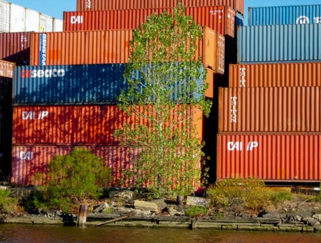 Shipping containers are just one of the industrial eyesores along the Passaic River in Newark.Photo: Mary BrunoWe passed abandoned factories and rotting docks on the Newark side of the river, and a junkyard with towers of pancaked sedans, and acres of red and blue shipping containers stacked seven high. Backlit and spectral, each eyesore had its own sad beauty. Together, they recalled a vanished era, the mid-19th century, when Newark was the king of U.S. manufacturing and the banks of the Passaic teemed with commerce.
About three miles upriver, just north of the Benjamin Moore paint factory, we came to the Diamond Alkali superfund site. The address, 80 Lister Avenue, is on the far eastern edge of Newark, in the city’s historic Ironbound district. Bill maneuvered the Aqua Patio in closer to shore, and shifted the engine into neutral. Most of the passengers stood — to take pictures, pay respects. Diamond isn’t the only superfund site along the Passaic, but it is by far the most notorious. For Passaic River advocates, 80 Lister Avenue is a battle cry.
From 1951 to 1983, the Diamond Alkali plant manufactured pesticides and weed killers and close to a million gallons of Agent Orange, the defoliant that U.S. military aircraft sprayed onto the jungles of South Viet Nam during the war. The process of making Agent Orange generated huge quantities of dioxin, a poisonous byproduct that remains the most carcinogenic substance known to man. Diamond’s dioxin poisoned its workers, its plant site, the surrounding neighborhood, and the river too. We were right to be afraid of the Passaic.
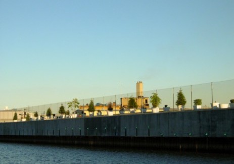 The six-acre, concrete grave for the remains of the Diamond Alkali plant. RIP.Photo: Mary BrunoThe remains of the Diamond Alkali plant were entombed beneath the grey concrete mound we floated past. It was the highlight of the tour. Fifteen feet high and about the size of a football field, the mound was secured behind a concrete bulkhead and a steel fence, sealed with multiple layers of clay, and capped with an impermeable “geofabric” membrane. The mound is a six-acre grave within which lie the remains of the deconstructed Diamond factory buildings and 932 shipping containers filled with 66,000 cubic yards of dioxin-contaminated dirt, dust and debris that environmental cleanup crews vacuumed from the streets, stores, schools, houses, playgrounds, and empty lots near the property.
A few thousand years from now, remarked Bill, archeologists studying this site will conclude that the people of the late 20th Century “built monuments to their pollution the way the ancient Egyptians built monuments to their pharaohs.” With that, he kicked the engine back in gear and we continued slowly upstream. The skyline of downtown Newark was just ahead. Sunlight lasered off the smoked glass windows of the FBI’s new riverside tower.
“How come there are no other boats on the river?” asked Janice. Her face was hidden beneath the peak of her white cotton cap, which was pulled low against the harsh sun. It was a good question, direct and obvious, and it cut to the heart of things. Even the poison mound and the Mad Max landscape and the occasional doomsday commentary from Andy and Bill hadn’t managed to spoil the simple joy of being out on the water.
My mother would have enjoyed this boat ride. She always dreamed of living by the water. Whenever she would mention this, my father would tease her: “You do!” he’d say. “You live on the Passaic River.”
In a way, he was right. There was a time when people would have coveted our home above the river. The Passaic was valued once, even beloved. Civic leaders harnessed its power to fuel their industrial revolution. Artists immortalized its beauty in paintings and verse. The river’s clear, navigable waters sustained the settlers, who farmed and fished its fertile basin, and built cities and towns, like mine, along its banks. But those days didn’t last.
The Passaic’s beauty had been ravaged and its bounty spent long before Janice posed her question. The river view mansions were boarded up. Riverfront hotels shut down. Rowing clubs disbanded. The benches in riverside parks were turned to face the street. By the time I was born the Passaic’s lower stretch was a garbage can, a cesspool. The river was poisoned and it was dead and even a kid like me could see it.
No one in my large extended family ever mentioned the state of the river. No one seemed to mourn it. The Passaic was something we crossed over or drove along, but it was never something we engaged. The river was like an elephant in the living room of my childhood. Its death was a ho-hum fact of life, like Friday night shore traffic on the Garden State Parkway or Hudson County politicians on the take. Some people must have fought for the river once. But the battle was long over. People moved on. Like those park benches, they turned their backs on the Passaic.
My mother, the water dreamer, told us not to play by the river, but she didn’t have to. How come there were no other boats on the Passaic River on this perfect late-September afternoon? I knew the answer to Janice’s question.
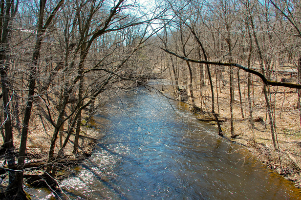 The Passaic River at Millington Gorge.Photo: John Bruno
There are hundreds of thousands of waterways in the continental United States, 3.5 million miles of endlessly moving liquid. How many of these waterways are technically rivers is a rather tricky question. “River” is not a scientific term. Indeed, science is a little laissez fair when it comes to classifying a waterway as, say, a stream versus a river.
My Webster’s Tenth Collegiate Dictionary defines a river as “a natural stream of water of considerable volume.” What constitutes “considerable volume” is left to someone else to decide. So it’s not surprising that rivers vary greatly in size and habit. Some are quite small; the D River in Oregon flows just 120 feet through Lincoln City to the Pacific Ocean. Some rivers are massive like the wide Missouri, which at 2,450 miles is America’s longest. Some rivers are ephemeral, surging into being after a desert downpour only to vanish with the rain, leaving behind a lacework of empty washes that hold the promise and threat of rushing water until the next big thunderstorm. A few rivers, like Florida’s Kissimmee, form gigantic puddles that sheet in slow motion, like the gentlest flood inching across a grassy sea some 40 miles wide.
Taken together, America’s rivers drain the countryside like a giant open vascular system that collects water from the interiors of the continent and transports it to the seas. Their precious cargo is pirated along the way for drinking, bathing, irrigating, recreating, and for powering millions of homes and industries. Rivers bring life, and they can take it away too. Such is the strange arithmetic of water: too much or too little is deadly.
Like the Passaic, most rivers are the raison d’etre for the communities and industries that have sprouted along their banks. There are thousands of river towns in the U.S. – Minneapolis, St.Louis, New Orleans, Augusta, Savannah, Albuquerque, el Paso, Cincinnati, Wheeling, Great Falls, Bismarck, Kansas City, Sioux City, Jefferson City, Omaha, Trenton, Toledo, Fort Wayne, Wilmington. Those are just some of the larger ones. The Passaic spawned Newark (1666) and Paterson, N.J. (1791), two erstwhile industrial powerhouses, as well as dozens of smaller communities like my home town. Like most rivers, the Passaic has paid dearly for its largesse.
In strictly physical terms, the Passaic is a fairly small river, just 90 miles long. Nevertheless, it is New Jersey’s longest river, edging out the Raritan by about five miles. The name Passaic means “peaceful valley” in the language of the Lenni Lenape, the Native American tribe that occupied northern New Jersey before the white settlers arrived.
The Passaic is many rivers: swift and clear in its upper stretch, sluggish and swampy in mid-section, a thundering cascade at Great Falls, brackish below the Dundee Dam, and so industrial in its final miles that New Jersey poet laureate William Carlos Williams declared it “the vilest swill hole.”
The river rises in Mendham, an historic township in north central Jersey. It heads almost due south at first, then veers sharply north, then northeast, then due east and then south again, making two final northward loops before emptying into Newark Bay. This erratic path traces a sloppy, upside-down U that winds through, over, under, and around seven New Jersey counties, 45 of its cities and towns, three swamps, three dams, four meadows, four waterfalls, a pond, a lake, 49 bridges and seven highways, and past countless homes, parks, playing fields, parking lots, diners, junkyards, office buildings, shopping centers, gas stations, warehouses, and factories. The drive from Mendham to Newark is about 30 miles. The Passaic takes the long way around.
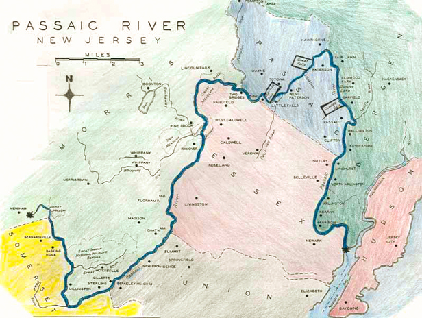 At 90 miles, the Passaic is the longest, crookedest, and most historic river in New Jersey. Map: Passaic River
The Passaic’s 90-mile journey can be divided into three long stretches. The Upper Passaic is a largely downhill romp through meadows and forest and along the southeastern edge of the Great Swamp National Wildlife Refuge. The Central Basin is the long, flat, flood-prone mid-section that flows north through an ancient lakebed. The Lower Valley, where I grew up, is a 35-mile-long corridor with sides that curl like plumped pillows as it sweeps down from the cliffs of Paterson to the sea level marshes of Newark.
In its convoluted journey from pristine headwaters to the superfund site at its mouth, the Passaic mirrors the triumphant and tragic relationship between nature and industry in America. The wildness and beauty that awed the first settlers some 400 years ago turned America into an industrial titan. Rivers like the Passaic powered the mills, farms, and factories that produced clothes, food, steel and electricity, a robust international trade, and a large and solid middle class. But along the way, the mighty frontier that helped forge American enterprise and character fell victim to an industrial fervor that seemed, at every turn, to sacrifice natural resources for financial gain.
The power and much of the breathtaking natural beauty of our national mountains, forests, rivers, and seas survives today only in the isolated patches of our national parks, and then just barely. “Our tools are better than we are,” wrote naturalist Aldo Leopold in his 1949 environmental classic A Sand County Almanac. “They suffice to crack the atom, to command the tides. But they do not suffice for the oldest task in human history: to live on a piece of land without spoiling it.” My great grandmother Emily Sullivan had a saying: “Don’t shit in the nest.” The Passaic River is an object lesson in what can happen when we ignore that simple, salty advice.
The Passaic changes character in the Lower Valley. Seventeen miles upstream of the river’s mouth in Newark Bay, the Dundee Dam crosses the river. The Passaic is fresh water above the dam. Below, the river becomes a swirl of fresh water and seawater whose salinity varies with conditions of weather, river flow, and ocean tide. Water levels in the river fluctuate about five feet with each daily tide. During extreme high tides, the Passaic can rise as much as 11 feet. When conditions are right — a high tide during the dry summer season, for instance — the tongue of saltwater from Newark Bay can lick the Dundee Dam, a full 17 miles upstream.
The Aqua Patio passengers were all quieter on the return trip, even Bill and Andy. I wondered what they would all take away from this experience. Andy used the Passaic River cruises to shake people up, open their eyes, confront them with the tragedy and the possibility of the Passaic. Later that year, he would take the mayors of Newark and Harrison out for a ride on the river. Baykeeper hosts cruises for local business leaders, for the press and for the general public too.
“Our job is to make advocates of people,” said Andy. He was giving me a lift back to my car, steering his Subaru Outback slowly along the paved streets that wind through the PVSC plant from the riverside dock to the visitor’s parking lot at the main entrance. “Remember Moby Dick?” he asked, out of the blue. “The first chapter is all about Manhattan. When industry and pollution kind of took the water away from people, the people responded appropriately: they turned their back on the waterway and took on other interests. Same thing with the Passaic. When the Passaic became foul, when it was no longer a place to picnic and boat and swim, it became less known to everyone except the people who worked on it. And those people used it as a highway and a toilet, and when it started to smell bad and people started to hear warnings about it, the Passaic became an unknown place.”
I left Andy standing in the parking lot, deep in conversation with the two environmental engineers from the cruise. My maiden voyage on the Passaic River had the desired effect. Andy would have been pleased. I didn’t get over my fear of the Passaic. But after the boat ride that fear mingled with curiosity and a kind of compassion. The river had touched me.
This is the first of a two-part excerpt from This American River: From Paradise to Superfund, Afloat on New Jersey’s Passaic.
Stay tuned for Part Two: Paddling the Passaic from its pristine beginning to its dioxin-laced end.
